Category:2009 Germany Bundestagswahl maps
Subcategories
This category has the following 3 subcategories, out of 3 total.
B
M
Media in category "2009 Germany Bundestagswahl maps"
The following 22 files are in this category, out of 22 total.
-
 17th Bundestag Structure.png 1,280 × 640; 182 KB
-
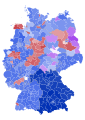
 2009 German federal election - Results by constituency.svg 4,135 × 4,807; 1.94 MB
-
 2009 German federal election - Results by state.svg 630 × 818; 152 KB
-
 2009 German federal election.svg 2,535 × 1,863; 1.85 MB
-
 Basse-Saxe (2009.1).png 706 × 622; 115 KB
-
 Bundestag 2009 PIRATEN.svg 1,836 × 1,930; 1.28 MB
-
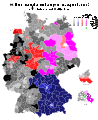
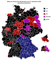 Bundestag Wahlkreise 2009 Erststimmenmehrheit.svg 1,656 × 1,992; 1.25 MB
-
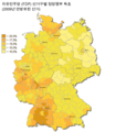
 Bundestagswahl2009 Beteiligung.svg 1,680 × 2,050; 1.26 MB
-
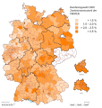
 Bundestagswahl2009 Erststimmen.svg 1,680 × 2,050; 1.26 MB
-
 Bundestag 2009 CDU-CSU.svg 1,962 × 1,969; 1.91 MB
-
-
 Bundestag 2009 FDP.svg 1,836 × 1,930; 1.28 MB
-
 FDP-Wahlkreise-2009.png 822 × 938; 361 KB
-
 FDP-선거구-2009.png 822 × 938; 311 KB
-
 German Federal Election - Party list vote results by state - 2009.png 1,030 × 1,300; 59 KB
-
 Bundestag 2009 Buendnisgruene.svg 1,836 × 1,930; 1.72 MB
-
 Bundestag 2009 Linke.svg 1,683 × 1,930; 826 KB
-
 Saxe (2009).png 468 × 366; 33 KB
-
 Schleswig-Holstein (2009).png 428 × 409; 34 KB
-
 Bundestag 2009 SPD.svg 1,962 × 1,969; 1.73 MB
-
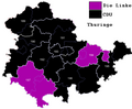 Thuringe (2009).png 420 × 345; 36 KB
-
 Bundestagswahl2009 Zweitstimmen.svg 1,680 × 2,050; 1.26 MB


.png)


.png)
.png)

.png)
