Category:2010 maps of India
Countries of Asia: People's Republic of China · Cyprus‡ · India · Indonesia‡ · Iran · Malaysia · Mongolia · Pakistan · Philippines · Russia‡
‡: partly located in Asia
‡: partly located in Asia
| ← 2010 2011 2012 2013 2014 2015 2017 2018 2019 → |
English: 2010 maps made in India or from India or showing history of India
Media in category "2010 maps of India"
The following 8 files are in this category, out of 8 total.
-
2 digit postcode india.png 885 × 885; 119 KB
-
2010 Andaman Islands Shakemap.jpg 612 × 724; 61 KB
-
Airports and seaports map.png 1,000 × 1,138; 236 KB
-
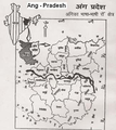
Angika speaking area.png 324 × 363; 131 KB
-
India regions.png 514 × 600; 92 KB
-
Indian Railways Rajdhani Shatabdi Lines.gif 1,000 × 1,138; 47 KB
-
Number of Native Speakers of Indian Languages world.png 1,666 × 1,215; 328 KB
-
State and union territories map.png 1,000 × 1,138; 71 KB


