Category:2012 aerial photographs of Canada
Media in category "2012 aerial photographs of Canada"
The following 173 files are in this category, out of 173 total.
-
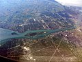 20120909 012 Detroit, Michigan (8390388509).jpg 4,000 × 3,000; 2.01 MB
-
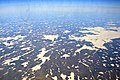
 Above the Swirl.jpg 2,400 × 1,779; 1.67 MB
-
 AC 319 Flight (YYZ to YEG) (6803811640).jpg 1,441 × 1,441; 908 KB
-
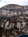 Aerial photograph of a cliff on Baffin Island.jpg 1,800 × 2,400; 2.3 MB
-
 Ajax ON.JPG 1,875 × 1,250; 1.29 MB
-
 UBC Law at Allard Hall.JPG 4,256 × 2,832; 3.29 MB
-
 Atikokan High School.JPG 4,608 × 3,456; 6.14 MB
-
 Auyuittuq National Park, Baffin Island, Nunavut -a.jpg 2,400 × 2,059; 2.02 MB
-
 Auyuittuq National Park, Baffin Island, Nunavut -b.jpg 2,400 × 1,410; 941 KB
-
 Auyuittuq National Park, Baffin Island, Nunavut -c.jpg 2,400 × 1,782; 2.18 MB
-
 Backed up Against the Wall.jpg 2,400 × 1,742; 1.91 MB
-
 Baffin Island remnant holdfast ice.jpg 2,400 × 1,800; 1.51 MB
-
 Basalt and Sea Ice Axel Heiberg Island Canada.jpg 2,592 × 1,944; 1.05 MB
-
 Big glacially polished cliff on Baffin Island.jpg 2,400 × 2,082; 2.48 MB
-
 Big Trout Lake.jpg 2,300 × 1,533; 821 KB
-
 Bruce Mines ON 2.JPG 2,000 × 1,333; 908 KB
-
 Burlington Heights looking south.jpg 2,400 × 1,486; 2.91 MB
-
 Bylot Island Glacier (cropped).jpg 3,200 × 1,286; 1.53 MB
-
 Bylot Island Glacier.jpg 3,200 × 1,670; 2.04 MB
-
 Canada Michigan St Claire river Ontario Lambton county Chatham-Kent county IMG 1826.JPG 3,456 × 4,681; 10.19 MB
-
 Canyon (7793385952).jpg 4,608 × 3,456; 3.52 MB
-
 Churchill aerial view.JPG 3,007 × 1,882; 2.91 MB
-
 Churchill aerial view2.JPG 3,008 × 2,000; 3.02 MB
-
 Churchill aerial view3.JPG 3,008 × 2,000; 2.42 MB
-
 Clover Point and Ross Bay. MORE INFO IN PANORAMIO-DESCRIPTION - panoramio.jpg 2,488 × 1,440; 568 KB
-
 Cochrane Alberta (8625233134).jpg 5,184 × 3,456; 2.29 MB
-
 Cockburn Island 1.JPG 1,600 × 960; 249 KB
-
 CYNJ Langley Regional CURRENT.JPG 5,184 × 3,456; 5.22 MB
-
 CYSN.jpg 1,522 × 1,444; 2.37 MB
-
 Deerfoot Trail at Memorial Drive 2.jpg 4,000 × 3,000; 2.23 MB
-
 Delta, BC, Canada - panoramio.jpg 3,664 × 2,748; 2.12 MB
-
 Edinburgh Island NWT 2.jpg 3,648 × 2,736; 3.35 MB
-
 Edinburgh Island NWT.jpg 3,648 × 2,736; 4.65 MB
-
 Edmonton City Centre Airport.jpg 1,302 × 774; 685 KB
-
 Ekwi River (7793400408).jpg 4,608 × 3,456; 3.8 MB
-
 Embro ON.JPG 2,048 × 1,365; 1.29 MB
-
 Fernridge, British Columbia, from the air.JPG 5,184 × 3,456; 6.37 MB
-
 Final Runway 30 Kugluktuk.jpg 3,648 × 2,736; 3.15 MB
-
 Fjord in northern Baffin Island, Nunavut.jpg 2,400 × 1,669; 1.29 MB
-
 Flying over Vancouver (13061583614).jpg 4,000 × 3,000; 7.22 MB
-
 FortMacKay.jpg 3,648 × 2,736; 2.91 MB
-
 Franklin dike on northwestern Baffin Island..jpg 2,400 × 1,732; 1.9 MB
-
 Glacier and Moraine in Nunavut in Canada.jpg 3,008 × 2,000; 2.02 MB
-
 Glacier, Glacial Lake, and Terminal Moraine, Baffin Island -a.jpg 2,400 × 1,821; 1.31 MB
-
 GM Oshawa.jpg 1,535 × 1,535; 938 KB
-
 Hanging Glaciers in nunavut.jpg 2,400 × 1,908; 2.1 MB
-
 HansIsland.png 940 × 657; 978 KB
-
 Helicopter Day (7569330138).jpg 2,592 × 1,944; 1.05 MB
-
 Highland Valley Copper Mine.JPG 4,000 × 3,000; 1.89 MB
-

-
 Hope Bay Gold Mine 01.jpg 3,648 × 2,736; 3.81 MB
-
 Hope Bay Gold Mine 02.jpg 3,648 × 2,668; 4.03 MB
-
 Hope Bay Gold Mine 03.jpg 3,648 × 2,736; 5.42 MB
-
 Hope Bay Gold Mine 04.jpg 3,648 × 2,736; 6.04 MB
-
 Hope Bay Gold Mine 05.jpg 3,648 × 2,736; 4.55 MB
-
 Kemess Mine in 2012.JPG 5,184 × 3,456; 5.05 MB
-
 Kingfisher Lake.JPG 1,944 × 2,592; 1.03 MB
-
 Kugluktuk NT.jpg 3,648 × 2,736; 4.43 MB
-
 Lake Erie Islands, Lake Erie in Ohio and Ontario, Canada (7992985986).jpg 4,000 × 3,000; 1.65 MB
-
 Langley Speedway from the ar.JPG 5,184 × 3,456; 5.23 MB
-
 Loch Lomond ON.JPG 2,048 × 1,536; 1.15 MB
-
 Long harbour and Ganges Harbour. INFO IN PANORAMIO DESCRIPTION - panoramio.jpg 3,648 × 2,736; 1.39 MB
-
 Lufa Farms Aerial view of Montreal rooftop greenhouse.jpg 1,800 × 1,200; 382 KB
-
 Lufa Farms Aerial view of Montreal rooftop greenhouse2.jpg 1,800 × 1,200; 379 KB
-
 Mackenzie Mountains (7793397162).jpg 4,392 × 3,294; 4.24 MB
-
 Mid-Borden Peninsula, Baffin Island.jpg 2,400 × 1,981; 1.9 MB
-
 Minnitaki Lake.JPG 1,462 × 1,949; 504 KB
-
 Montreal-Dorval Airport 1.JPG 2,000 × 1,333; 816 KB
-
 Montreal-Dorval Airport 1c.JPG 1,000 × 667; 247 KB
-
 Mouth of the Churchill River at Hudson Bay (7461042054).jpg 1,280 × 853; 300 KB
-
 MV Ithaca aerial view1.JPG 2,958 × 2,214; 2.9 MB
-
 MV Ithaca aerial view2.JPG 3,648 × 2,736; 3.94 MB
-
 MV Ithaca aerial view3.JPG 3,420 × 2,144; 3.31 MB
-
 Nakiska ski hills Alberta (8625233430).jpg 5,184 × 3,456; 2.22 MB
-
 Nelson River near Norway House, from the air.jpg 3,648 × 2,736; 1.86 MB
-
 Ontario Chatham-Kent county Dresden city IMG 1835.JPG 3,456 × 5,184; 8.51 MB
-
 Ontario Chatham-Kent county east Camden Township Thames river IMG 1838.JPG 4,684 × 2,821; 5.95 MB
-
 Ontario Chatham-Kent county east Camden Township Thames river IMG 1839.JPG 5,010 × 3,456; 10.07 MB
-
 Ontario Chatham-Kent county east Elgin county west Lake Erie IMG 1844.JPG 5,086 × 2,901; 7.9 MB
-
 Ontario Chatham-Kent county east Lake Erie IMG 1840.JPG 5,184 × 2,718; 8.47 MB
-
 Ontario Chatham-Kent county east with Sydenham river Dresden city IMG 1837.JPG 3,456 × 4,942; 10.52 MB
-
 Ontario Chatham-Kent county Wallaceburg city IMG 1830.JPG 3,456 × 4,867; 9.79 MB
-
 Ontario Chatham-Kent county Wallaceburg city IMG 1831.JPG 3,456 × 5,184; 11.66 MB
-
 Ontario Chatham-Kent county Wallaceburg city IMG 1833.JPG 5,184 × 3,456; 10.44 MB
-
 Ontario Chatham-Kent east Elgin co west Lake Erie IMG 1846.JPG 3,456 × 4,196; 7.62 MB
-
 Ontario Elgin county Big Otter Creek river Port Burwell and Lake Erie IMG 1851.JPG 5,005 × 2,817; 8.65 MB
-
 Ontario Elgin county east Norfolk county west with Clear Creek river and Lake Erie IMG 1853.JPG 5,123 × 3,006; 11.13 MB
-
 Ontario Elgin county Port Stanley and Lake Erie IMG 1850.JPG 5,184 × 2,307; 7.59 MB
-
 Ontario Elgin county Port Stanley IMG 1847.JPG 4,911 × 2,562; 9.08 MB
-
 Ontario Elgin county Port Stanley IMG 1848.JPG 3,357 × 2,276; 4.91 MB
-
 Ontario Elgin county Wallacetown municipality Lake Erie IMG 1842.JPG 5,026 × 3,226; 11.2 MB
-
 Ontario Elgin county Wallacetown municipality Lake Erie IMG 1843.JPG 5,086 × 3,257; 9.92 MB
-
 Ontario Elgin county Wallacetown municipality Lake Erie IMG 1845.JPG 5,048 × 2,997; 8.37 MB
-
 Ontario Elgin county with Big Otter Creek river Port Burwell and Lake Erie IMG 1852.JPG 4,284 × 2,730; 8.4 MB
-

-
 Ontario Norfolk county Long Point Lake Erie IMG 1856.JPG 5,074 × 3,198; 7.66 MB
-
 Ontario Norfolk county Long Point Lake Erie IMG 1857.JPG 5,037 × 2,518; 7.35 MB
-
 Ontario Norfolk county Long Point Lake Erie IMG 1858.JPG 5,054 × 1,648; 4.98 MB
-
 Outcrops and Sea Ice (7569335296).jpg 2,592 × 1,944; 1.46 MB
-
 Parry Island.JPG 1,555 × 1,920; 877 KB
-
 Pelee Island and Middle Island, Ontario, Canada (7238171558).jpg 3,000 × 4,000; 1.88 MB
-
 Perched irrigated fields in the arid Fraser gorge above the Big Bar ferry (7959741892).jpg 2,121 × 1,414; 2.73 MB
-
 Point Pelee National Park, Ontario, Canada (7238172160).jpg 3,000 × 4,000; 6.34 MB
-
 Polygonal Ground in Nunavut in Canada - Aerial photo.jpg 2,592 × 1,944; 1 MB
-
 Port of Churchill aerial view.JPG 3,008 × 2,000; 2.73 MB
-
 Prairie Storm (7608957886).jpg 2,048 × 1,232; 1.32 MB
-
 Prince of Wales Fort, Churchill, MB.jpg 3,648 × 2,736; 4.58 MB
-
 RichardsonBackcountry.JPG 3,648 × 2,736; 2.3 MB
-
 River (7793393330).jpg 4,608 × 3,456; 4.05 MB
-
 Riviere Mille Iles.JPG 1,536 × 1,806; 1.06 MB
-
 Runway, Gore Bay Manitoulin Airport.jpg 4,752 × 3,168; 5.29 MB
-
 Salt Diapir Axel Heiberg Island Canada.jpg 1,944 × 2,592; 1.22 MB
-
 Sea Ice - 2 (7569331464).jpg 2,592 × 1,944; 1.24 MB
-
 Sea ice on Hudson Bay near Cape Churchill.JPG 3,008 × 2,000; 2.62 MB
-
 Shadow of the Wolf (7055313995).jpg 2,402 × 1,790; 2.1 MB
-
 Silver Islet ON.JPG 2,000 × 1,333; 818 KB
-
 Sioux Lookout ON 2.JPG 1,600 × 1,066; 237 KB
-
 Sleeping Giant PP.JPG 1,536 × 2,048; 841 KB
-

-
 Southern Gulf Islands, BC, Canada - panoramio (15).jpg 3,664 × 2,748; 2.3 MB
-
 Southern Gulf Islands, BC, Canada - panoramio (16).jpg 3,664 × 2,748; 2.5 MB
-
 Southern Ontario at night.png 954 × 608; 876 KB
-
 St-Michel-Saints QC.JPG 1,320 × 880; 421 KB
-
 Surrey aerial view.JPG 2,048 × 1,536; 1.04 MB
-
 SYNCRUDE 2012 (7173999608).jpg 4,288 × 3,216; 2.24 MB
-
 SYNCRUDE 2012 (7174002070).jpg 4,288 × 3,216; 2.22 MB
-
 SYNCRUDE 2012 (7174004158).jpg 4,288 × 3,216; 1.96 MB
-
 SYNCRUDE 2012 (7174009398).jpg 4,288 × 3,216; 5.17 MB
-
 SyncrudeWoodBuffalo.JPG 3,648 × 2,736; 2.31 MB
-
 Thames Centre ON.JPG 1,800 × 1,500; 1.01 MB
-
 The Town of Churchill as seen from the port.jpg 1,280 × 473; 253 KB
-
 Thorah Island.JPG 1,260 × 840; 143 KB
-
 Tilted Rock Layers in Nunavut in Canada.jpg 3,008 × 2,000; 1.9 MB
-
 Town of Churchill aerial view.JPG 3,648 × 2,736; 4.77 MB
-
 Tug boat pushing log raft near Vancouver.jpg 2,400 × 1,600; 911 KB
-
 Tundra Lodge, Churchill.JPG 2,664 × 2,002; 3.21 MB
-
 Vancouver - panoramio (21).jpg 3,664 × 2,748; 1.89 MB
-
 Vancouver - panoramio (22).jpg 3,664 × 2,748; 2.06 MB
-
 Vancouver - panoramio (23).jpg 3,664 × 2,748; 1.78 MB
-
 Vancouver - panoramio (24).jpg 3,664 × 2,748; 2.27 MB
-
 Vancouver - panoramio (25).jpg 3,664 × 2,748; 1.81 MB
-
 Vancouver - panoramio (26).jpg 3,664 × 2,748; 1.87 MB
-
 Vancouver - panoramio (27).jpg 3,664 × 2,748; 2.53 MB
-
 Vancouver - panoramio (28).jpg 3,664 × 2,748; 2.45 MB
-
 Vancouver - panoramio (29).jpg 3,664 × 2,748; 2.6 MB
-
 Vancouver - panoramio (30).jpg 3,664 × 2,748; 2.55 MB
-
 Vancouver - panoramio (31).jpg 3,664 × 2,748; 2.06 MB
-
 Vancouver - panoramio (32).jpg 3,664 × 2,748; 2.34 MB
-
 Vancouver - panoramio (33).jpg 3,664 × 2,748; 2.07 MB
-
 Vancouver - panoramio (34).jpg 3,664 × 2,748; 1.92 MB
-
 Victoria golf course. MORE INFO IN PANORAMIO-DESCRIPTION - panoramio.jpg 2,742 × 1,749; 1,016 KB
-
 Victoria Island - panoramio (10).jpg 3,664 × 2,748; 2.35 MB
-
 Victoria Island - panoramio (11).jpg 3,664 × 2,748; 2.42 MB
-
 Victoria Island - panoramio (13).jpg 3,664 × 2,748; 2.38 MB
-
 Victoria Island - panoramio (14).jpg 3,664 × 2,748; 2.11 MB
-
 Victoria Island - panoramio (15).jpg 3,664 × 2,748; 1.9 MB
-
 Victoria Island - panoramio (16).jpg 3,664 × 2,748; 2.19 MB
-
 Victoria Island - panoramio (17).jpg 3,664 × 2,748; 2.14 MB
-
 Victoria Island - panoramio (18).jpg 3,664 × 2,748; 1.94 MB
-
 Victoria Island - panoramio (19).jpg 3,664 × 2,748; 2.25 MB
-
 Victoria Island - panoramio (2).jpg 3,664 × 2,748; 2.37 MB
-
 Victoria Island - panoramio (3).jpg 3,664 × 2,748; 2.4 MB
-
 Victoria Island - panoramio (4).jpg 3,664 × 2,748; 2.49 MB
-
 Victoria Island - panoramio (5).jpg 3,664 × 2,748; 2.2 MB
-
 Victoria Island - panoramio (6).jpg 3,664 × 2,748; 2.53 MB
-
 Victoria Island - panoramio (7).jpg 3,664 × 2,748; 2.55 MB
-
 Victoria Island - panoramio (8).jpg 3,664 × 2,748; 1.98 MB
-
 Victoria Island - panoramio (9).jpg 3,664 × 2,748; 2.48 MB
-
 Victoria Island - panoramio.jpg 3,664 × 2,748; 2.48 MB
-
 Wapusk polar bears aerial view.JPG 3,648 × 2,736; 4.59 MB
-
 Watson Lake Airport, Watson Lake, Yukon Territory.jpg 2,705 × 1,870; 1.91 MB
-
 Whitehorse Airport, Yukon Territory.jpg 3,468 × 2,300; 2.74 MB
-
 Wunnummin Lake.JPG 2,592 × 1,728; 920 KB
.jpg)

_(6803811640).jpg)


.jpg)


.jpg)


.jpg)


.jpg)


.jpg)


.jpg)


.jpg)


.jpg)


.jpg)


.jpg)

.jpg)
.jpg)
.jpg)


.jpg)


.jpg)


.jpg)

.jpg)


.jpg)
.jpg)


.jpg)
.jpg)
.jpg)
.jpg)


.jpg)
.jpg)
.jpg)
.jpg)
.jpg)
.jpg)
.jpg)
.jpg)
.jpg)
.jpg)
.jpg)
.jpg)
.jpg)
.jpg)

.jpg)
.jpg)
.jpg)
.jpg)
.jpg)
.jpg)
.jpg)
.jpg)
.jpg)
.jpg)
.jpg)
.jpg)
.jpg)
.jpg)
.jpg)
.jpg)
.jpg)


.jpg)