Category:2018 United States House of Representatives election maps of Arizona
States of the United States: Alabama · Alaska · Arizona · Arkansas · California · Colorado · Florida · Indiana · Iowa · Kansas · Kentucky · Massachusetts · Michigan · New Jersey · New Mexico · Ohio · Oklahoma · Oregon · Pennsylvania · South Carolina · Utah · West Virginia · Wisconsin
Media in category "2018 United States House of Representatives election maps of Arizona"
The following 9 files are in this category, out of 9 total.
-
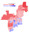
 2018 AZ-03 election by precinct.svg 2,699 × 1,630; 1.23 MB
-
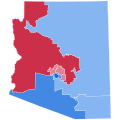
 2018 AZ-1 Election Results by Precinct.svg 1,052 × 744; 4.83 MB
-
 2018 AZ-4 Election Results by Precinct.svg 3,384 × 4,441; 2.52 MB
-
 2018AZUSHouse.svg 810 × 810; 145 KB
-
 AZ District 1 Counties 2018.svg 747 × 702; 588 KB
-
 AZ District 2 Counties 2018.svg 800 × 463; 50 KB
-
 AZ District 3 Counties 2018.svg 800 × 411; 131 KB
-
 AZ District 4 Counties 2018.svg 800 × 879; 799 KB
-
 AZ-08 2018 special.svg 800 × 927; 282 KB


