Category:2019 maps of Großrinderfeld
Media in category "2019 maps of Großrinderfeld"
The following 5 files are in this category, out of 5 total.
-
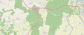 Anschlussstellen 1 (Dreieck Würzburg-West) und 2 (Gerchsheim) der A 81.png 1,864 × 780; 1.21 MB
-
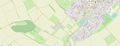
 Lage Altertheimer Weg (Großrinderfeld) bei Großrinderfeld-Gerchsheim.png 1,877 × 837; 410 KB
-
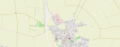 Lage Beund (Großrinderfeld).png 1,847 × 722; 477 KB
-
 Lage Gewerbegebiet Gerchsheim.png 1,860 × 716; 779 KB
-
 Lage Siedlung (Großrinderfeld).png 1,860 × 708; 711 KB
_und_2_(Gerchsheim)_der_A_81.png)
_bei_Gro%C3%9Frinderfeld-Gerchsheim.png)
.png)
.png)