Category:2020s maps of East Timor
Media in category "2020s maps of East Timor"
The following 13 files are in this category, out of 13 total.
-

-
 2021-12-29 Lospalos, Timor Leste M7.3 earthquake shakemap (USGS).jpg 785 × 981; 183 KB
-

-
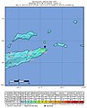
 2022-02-01 Lospalos, Timor Leste M6 earthquake shakemap (USGS).jpg 777 × 995; 148 KB
-

-
 2022-05-27 Lospalos, Timor Leste M6.1 earthquake shakemap (USGS).jpg 807 × 1,001; 98 KB
-

-
 2022-05-27 Lospalos, Timor Leste M6.2 earthquake shakemap (USGS).jpg 807 × 998; 95 KB
-
 2023 East Timorese parliamentary election - Results by municipality.svg 1,607 × 806; 811 KB
-
 2022 East Timor presidential election.png 4,949 × 1,016; 218 KB
-
 TL-parlam 2023.png 3,344 × 1,929; 249 KB
-
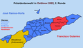 TL-president 2022-02.png 3,344 × 1,929; 370 KB
-
 TL-president 2022.png 3,344 × 1,929; 392 KB
.jpg)
.jpg)
.jpg)
.jpg)
.jpg)
.jpg)
.jpg)
.jpg)


