Category:A15 road (England)
road in England  | |||||
| Upload media | |||||
| Instance of | |||||
|---|---|---|---|---|---|
| Location |
| ||||
| Transport network |
| ||||
| Has part(s) |
| ||||
| Length |
| ||||
| Different from | |||||
 | |||||
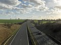
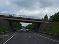
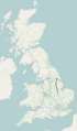
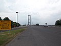
English: The A15 is the main north-south road in Cambridgeshire and Lincolnshire, running the entire length of that county. It has a length of 95 miles between Hessle, near Kingston upon Hull, and Norman Cross, Peterborough via Lincoln, Sleaford and Bourne. It is also the road that crosses the Humber Bridge.
Subcategories
This category has the following 6 subcategories, out of 6 total.
H
L
M
- Milestones on A15 (23 F)
N
- North Street, Bourne (33 F)
S
- South Street, Bourne (23 F)
T
- Thorn Bridge, Lincoln (3 F)
Media in category "A15 road (England)"
The following 95 files are in this category, out of 95 total.
-
 -2020-10-30 North Street, Bourne, Lincolnshire.jpg 6,252 × 4,164; 3.59 MB
-
 A15 - Entry Slip Road from the A1077 - geograph.org.uk - 1099784.jpg 640 × 480; 71 KB
-
 A15 - geograph.org.uk - 494323.jpg 640 × 480; 118 KB
-
 A15 - geograph.org.uk - 666417.jpg 640 × 478; 73 KB
-
 A15 bridge Market Deeping (geograph 2375602).jpg 2,592 × 1,944; 1.34 MB
-
 A15 exit to Barton-Upon-Humber - geograph.org.uk - 39932.jpg 640 × 426; 71 KB
-
 A15 heading north towards Sleaford (geograph 3699151).jpg 640 × 480; 50 KB
-
 A15 Messingham lane flyover - geograph.org.uk - 1422166.jpg 640 × 480; 42 KB
-
 A15 near Dogsthorpe - geograph.org.uk - 1366758.jpg 640 × 477; 60 KB
-
 A15 Near Norman Cross - geograph.org.uk - 1334788.jpg 640 × 480; 205 KB
-
 A15 Northbound - geograph.org.uk - 1099766.jpg 640 × 514; 52 KB
-

-
 A15 Peterborough (City Centre) Dec 2012.jpg 2,048 × 1,536; 717 KB
-
 A15 Peterborough City Centre Feb 2013.jpg 2,048 × 1,536; 699 KB
-
 A15 Queensgate (Dec 2012).jpg 2,048 × 1,536; 625 KB
-
 A15 road map.png 250 × 425; 48 KB
-
 A15 south at Folkingham (geograph 2505160).jpg 640 × 480; 89 KB
-
 A15 Southbound - geograph.org.uk - 909094.jpg 640 × 427; 62 KB
-
 A15 Underpass near Elsham Hill - geograph.org.uk - 1779762.jpg 750 × 1,000; 447 KB
-
 A15 viewed from footbridge - geograph.org.uk - 968118.jpg 640 × 480; 67 KB
-
 A15(T) - geograph.org.uk - 276664.jpg 640 × 482; 85 KB
-
 A15-A1077 Junction near Barton Upon Humber - geograph.org.uk - 1779711.jpg 1,000 × 750; 602 KB
-
 A15-B1206 turn-off - geograph.org.uk - 51498.jpg 640 × 403; 63 KB
-
 Aircraft crossing - geograph.org.uk - 1255311.jpg 640 × 480; 33 KB
-

-
 Atterby Lane junction with the A15 - geograph.org.uk - 124844.jpg 640 × 426; 104 KB
-
 B1218 Crossing over the A15 - geograph.org.uk - 960155.jpg 640 × 420; 64 KB
-
 Bourne Road (A15) (geograph 3699077).jpg 640 × 480; 55 KB
-
 Crossing the A15 - geograph.org.uk - 848959.jpg 640 × 480; 63 KB
-
 Caenby Corner roundabout-Geograph-1316490-by-Peter-Church.jpg 640 × 427; 330 KB
-
 Car dealers on London Road, Osbournby (geograph 3699142).jpg 640 × 480; 55 KB
-
 Cycle Path beside the A15 - geograph.org.uk - 1734678.jpg 800 × 600; 169 KB
-
 A15 Underpass - geograph.org.uk - 1058264.jpg 640 × 425; 75 KB
-
 Looking towards Elsham Hill - geograph.org.uk - 1302984.jpg 640 × 480; 67 KB
-
 Road Liable to Flooding - geograph.org.uk - 1421338.jpg 640 × 425; 79 KB
-
 Entrance to Lawress Hall - geograph.org.uk - 275154.jpg 640 × 480; 93 KB
-
 Felixstowe Beach level crossing 2012.jpg 1,024 × 768; 309 KB
-
 Ferriby Road - geograph.org.uk - 1460701.jpg 640 × 480; 81 KB
-
 Ferriby Road, Hessle - geograph.org.uk - 491853.jpg 640 × 478; 198 KB
-
 Ferriby Road, Hessle - geograph.org.uk - 689084.jpg 640 × 400; 95 KB
-
 Field and the A15 beyond - geograph.org.uk - 1526248.jpg 640 × 404; 80 KB
-
 Freezing Fog on the A15 - geograph.org.uk - 1063530.jpg 640 × 425; 52 KB
-
 Freezing Fog on the A15 - geograph.org.uk - 1066203.jpg 640 × 425; 46 KB
-
 A15 Cleatham Crossroads - geograph.org.uk - 1422152.jpg 640 × 480; 31 KB
-
 A15 from Manton Lane - geograph.org.uk - 758138.jpg 640 × 359; 70 KB
-
 A15 railway crossing - geograph.org.uk - 1422155.jpg 640 × 480; 41 KB
-
 Lay-by on the A15 west of Hibaldstow - geograph.org.uk - 583632.jpg 640 × 480; 180 KB
-
 Public Footpath crosses the A15 - geograph.org.uk - 1422149.jpg 640 × 480; 42 KB
-
 Track just off the A15 road to Staniwells - geograph.org.uk - 583637.jpg 640 × 480; 179 KB
-
 Humber Bridge - Northern Approach - geograph.org.uk - 193031.jpg 640 × 480; 65 KB
-
 Junction of A15 and A1077 - geograph.org.uk - 666411.jpg 640 × 480; 77 KB
-
 Junction of the A15 and A1077 - geograph.org.uk - 302658.jpg 640 × 427; 128 KB
-
 Landing Lights - geograph.org.uk - 982033.jpg 640 × 480; 46 KB
-
 -2021-03-16 Looking north along the A15, Rippingdale, Lincolnshire.jpg 6,252 × 4,164; 4.54 MB
-
 -2021-03-16 Looking north along the A15, Rippingdale.jpg 5,575 × 3,713; 7.53 MB
-
 -2021-03-16 Looking south along the A15, Rippingdale, Lincolnshire.jpg 5,575 × 3,713; 7.23 MB
-
 Looking towards Bourne on the A15 - geograph.org.uk - 312149.jpg 640 × 427; 74 KB
-
 Melville Street (A15), Lincoln - geograph.org.uk - 3697670.jpg 640 × 426; 89 KB
-
 Melville Street (A15), Lincoln - geograph.org.uk - 3697680.jpg 426 × 640; 77 KB
-
 Poppy Time - geograph.org.uk - 423774.jpg 640 × 480; 123 KB
-
 Ruined farmhouse near Green Man woods - geograph.org.uk - 139767.jpg 640 × 427; 56 KB
-
 Brick Patterns, Norman Cross - geograph.org.uk - 885202.jpg 640 × 480; 65 KB
-
 Over the A15 - geograph.org.uk - 1526295.jpg 640 × 480; 86 KB
-
 Passing under the A15(T) - geograph.org.uk - 168560.jpg 640 × 480; 104 KB
-
 A15 north towards the M180 - geograph.org.uk - 326757.jpg 640 × 480; 78 KB
-
 Robin Hood and Little John - geograph.org.uk - 275210.jpg 640 × 427; 51 KB
-
 Roundabout on the A15 - geograph.org.uk - 1734654.jpg 800 × 600; 103 KB
-
 A15 near Scawby - geograph.org.uk - 234368.jpg 640 × 427; 95 KB
-
 A15 towards the M180 - geograph.org.uk - 1422162.jpg 640 × 480; 39 KB
-
 The A15 road south west of Scawby - geograph.org.uk - 583630.jpg 640 × 480; 137 KB
-
 Shops on North Street (geograph 3588616).jpg 4,320 × 3,240; 5.58 MB
-
 Speed Camera on A15 - geograph.org.uk - 403331.jpg 640 × 442; 71 KB
-
 A15 near Temple High Grange - geograph.org.uk - 328481.jpg 640 × 427; 80 KB
-
 The A15 at Barton Hill - geograph.org.uk - 960142.jpg 640 × 480; 85 KB
-

-

-
 The A15 south of Barton - geograph.org.uk - 1713066.jpg 640 × 426; 210 KB
-
 The A15, B1206 junction - geograph.org.uk - 1422138.jpg 640 × 386; 31 KB
-
 The A15, Lincoln - geograph.org.uk - 690346.jpg 640 × 483; 60 KB
-
 The busy A15 - geograph.org.uk - 326805.jpg 640 × 480; 70 KB
-

-
 The old A15 - geograph.org.uk - 339380.jpg 640 × 480; 136 KB
-
 The Tally Ho Inn, on the A15 (geograph 2805324).jpg 800 × 600; 107 KB
-
 The Tree - geograph.org.uk - 115174.jpg 640 × 427; 175 KB
-
 Threekingham-Bar-by-Glyn-Drury.jpg 640 × 480; 43 KB
-
 Travelling North - geograph.org.uk - 360133.jpg 640 × 422; 82 KB
-
 UK road A15.PNG 568 × 184; 5 KB
-
 UK road A15.svg 345 × 191; 4 KB
-
 Underpass - geograph.org.uk - 359077.jpg 640 × 480; 120 KB
-
 Westfield Road Cut by the A15 - geograph.org.uk - 1176219.jpg 640 × 480; 121 KB
-

-

-
 Eye roundabout, Peterborough - geograph.org.uk - 354159.jpg 640 × 428; 97 KB
-
 Osbournby Roundabout - geograph.org.uk - 360104.jpg 640 × 480; 81 KB
-
 Pedestrian crossing - geograph.org.uk - 672644.jpg 640 × 480; 77 KB


.jpg)

.jpg)


_Dec_2012.jpg)

.jpg)
.jpg)


_-_geograph.org.uk_-_276664.jpg)


_-_geograph.org.uk_-_545654.jpg)


_(geograph_3699077).jpg)


.jpg)


,_Lincoln_-_geograph.org.uk_-_3697670.jpg)
,_Lincoln_-_geograph.org.uk_-_3697680.jpg)


_-_geograph.org.uk_-_168560.jpg)


.jpg)


_on_its_way_to_Grimsby_-_geograph.org.uk_-_2186517.jpg)

.jpg)


