Category:A166 road from Stamford Bridge to Fridaythorpe
Media in category "A166 road from Stamford Bridge to Fridaythorpe"
The following 13 files are in this category, out of 13 total.
-
 A166 towards Fridaythorpe - geograph.org.uk - 1541378.jpg 640 × 480; 48 KB
-
 A166 towards York (Man Street) - geograph.org.uk - 1374855.jpg 640 × 480; 79 KB
-
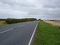
 A166 towards York - geograph.org.uk - 1838218.jpg 640 × 480; 47 KB
-
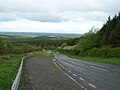 A166, Garrowby Hill with emergency run off lane.jpg 640 × 480; 62 KB
-
 Crossroads on the A166 - geograph.org.uk - 285345.jpg 640 × 480; 86 KB
-
 Entering Fridaythorpe (geograph 3110637).jpg 640 × 437; 96 KB
-
 Fridaythorpe village (geograph 5984605).jpg 1,024 × 768; 185 KB
-
 Garrowby Lodge - geograph.org.uk - 125982.jpg 640 × 480; 138 KB
-
 Garrowby Lodge.jpg 640 × 468; 80 KB
-
 Road junction near Garrowby Wold - geograph.org.uk - 1437802.jpg 640 × 449; 40 KB
-
 Site of the former Hare & Hounds public house (geograph 6574170).jpg 1,600 × 1,065; 639 KB
-
 South of Fridaythorpe - geograph.org.uk - 125356.jpg 640 × 480; 185 KB
-
 The road to Stamford Bridge - geograph.org.uk - 411472.jpg 640 × 480; 86 KB

_-_geograph.org.uk_-_1374855.jpg)


.jpg)
.jpg)


.jpg)

