Category:A34 road at East Ilsley
Media in category "A34 road at East Ilsley"
The following 20 files are in this category, out of 20 total.
-
 A34 approaches Shrill Down - geograph.org.uk - 2533493.jpg 3,648 × 2,736; 952 KB
-
 A34 crosses the Dennisford Road - geograph.org.uk - 2905777.jpg 3,536 × 2,727; 1.35 MB
-
 A34 junction at East Ilsley - geograph.org.uk - 2533504.jpg 3,647 × 2,577; 851 KB
-
 A34 lay-by at Shrill down - geograph.org.uk - 3103630.jpg 640 × 480; 45 KB
-
 A34 north of East Ilsley - geograph.org.uk - 2533518.jpg 3,643 × 2,545; 940 KB
-
 A34 north of East Ilsley - geograph.org.uk - 3671221.jpg 640 × 438; 41 KB
-
 A34 northbound - geograph.org.uk - 3341283.jpg 640 × 480; 54 KB
-
 A34 northbound - geograph.org.uk - 3341287.jpg 640 × 480; 47 KB
-

-

-
 A34 southbound near Gore Hill - geograph.org.uk - 3103619.jpg 640 × 480; 61 KB
-
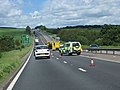 Accident on the A34 - geograph.org.uk - 4059643.jpg 1,024 × 768; 140 KB
-
 Jam near East Ilsley - geograph.org.uk - 4059641.jpg 1,024 × 768; 159 KB
-
 Layby on Southbound A34 near East Ilsley - geograph.org.uk - 4147661.jpg 640 × 480; 234 KB
-
 Layby on the A34 near East Ilsley - geograph.org.uk - 3292071.jpg 640 × 480; 465 KB
-
 Southbound A34 - geograph.org.uk - 4147659.jpg 640 × 480; 254 KB
-

-
 The A34 - geograph.org.uk - 1160314.jpg 640 × 426; 107 KB
-
 The A34 heading north - geograph.org.uk - 4578769.jpg 1,500 × 999; 131 KB
-
 The A34 heading north over Nutfield Down - geograph.org.uk - 4578765.jpg 1,500 × 999; 150 KB


