Category:A4104 road (England)

road in England | |||||
| Upload media | |||||
| Instance of | |||||
|---|---|---|---|---|---|
| Location |
| ||||
| Transport network |
| ||||
| |||||
Subcategories
This category has only the following subcategory.
W
Media in category "A4104 road (England)"
The following 85 files are in this category, out of 85 total.
-
 A38 junction with the A4104 - geograph.org.uk - 1670442.jpg 640 × 480; 57 KB
-
 A38 junction with the A4104 - geograph.org.uk - 1670443.jpg 640 × 480; 48 KB
-
 A4104 approaching the A38 junction - geograph.org.uk - 1638166.jpg 640 × 426; 68 KB
-
 A4104 at Lower Hook - geograph.org.uk - 1609620.jpg 640 × 480; 100 KB
-
 A4104 near Earl's Croome - geograph.org.uk - 1670449.jpg 640 × 480; 55 KB
-

-
 Baughton - public call box - geograph.org.uk - 836175.jpg 640 × 480; 87 KB
-
 Bench Mark on Milestone beside the A4104 - geograph.org.uk - 1780389.jpg 411 × 640; 335 KB
-
 Byefield Lane junction - geograph.org.uk - 838971.jpg 640 × 480; 109 KB
-
 Causeway into Upton - geograph.org.uk - 1628719.jpg 640 × 412; 268 KB
-
 Clearing the A4104 - geograph.org.uk - 334453.jpg 640 × 443; 249 KB
-

-
 Defford Bridge - geograph.org.uk - 4351.jpg 640 × 480; 56 KB
-
 Defford Bridge and Baker's Hill - geograph.org.uk - 1062544.jpg 640 × 426; 78 KB
-
 Entrance to Pershore Cemetery - geograph.org.uk - 1161582.jpg 640 × 480; 114 KB
-
 Entrance to Tiddesley Wood - geograph.org.uk - 1158334.jpg 640 × 480; 160 KB
-
 Entrance to Welland - geograph.org.uk - 1171702.jpg 640 × 432; 256 KB
-
 Footpath under the A4104 - geograph.org.uk - 764261.jpg 640 × 480; 79 KB
-
 Holly Green junction - geograph.org.uk - 836153.jpg 640 × 480; 83 KB
-
 House overlooking the River Avon - geograph.org.uk - 965808.jpg 640 × 426; 91 KB
-
 Houses on the A4104 - geograph.org.uk - 712748.jpg 640 × 427; 248 KB
-

-
-
 Little Malvern - geograph.org.uk - 1293854.jpg 640 × 480; 192 KB
-

-
 The Marlbank Inn - geograph.org.uk - 427560.jpg 640 × 427; 241 KB
-
-
 Marsh Common and the A4104 - geograph.org.uk - 1007557.jpg 640 × 480; 114 KB
-
 Mayalls Farm, from A4104 - geograph.org.uk - 823176.jpg 640 × 480; 63 KB
-
 Milestone by the A4104 - geograph.org.uk - 1780378.jpg 640 × 427; 312 KB
-
 Mistletoe Spheres - geograph.org.uk - 690535.jpg 640 × 427; 242 KB
-
 New Sign for Hancocks Lane - geograph.org.uk - 496441.jpg 640 × 427; 255 KB
-
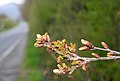 Oak Buds Emerging - geograph.org.uk - 772518.jpg 640 × 431; 219 KB
-
 Pear Tree near Days Farm - geograph.org.uk - 772474.jpg 640 × 427; 262 KB
-
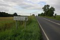
 Pershore town sign - 2 - geograph.org.uk - 1161564.jpg 640 × 480; 78 KB
-
 Pershore town sign - geograph.org.uk - 1161552.jpg 640 × 480; 95 KB
-
 Restored fence - geograph.org.uk - 842346.jpg 640 × 427; 319 KB
-
 Road junction at Lower Hook - geograph.org.uk - 1609630.jpg 640 × 480; 103 KB
-
 Road junction at Tunnel Hill - geograph.org.uk - 1615960.jpg 640 × 480; 92 KB
-

-
 Road Markings on A4104 - geograph.org.uk - 481063.jpg 640 × 427; 257 KB
-
 Road to Little Malvern - geograph.org.uk - 1654364.jpg 640 × 427; 265 KB
-
 Start of the A4104, Little Malvern - geograph.org.uk - 335076.jpg 640 × 427; 256 KB
-

-
 The A4104 at Earl's Croome - geograph.org.uk - 1638155.jpg 640 × 426; 70 KB
-
 The A4104 at Woodmancote - geograph.org.uk - 792597.jpg 640 × 426; 74 KB
-
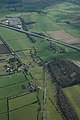
 The A4104 crosses over the M5 motorway - geograph.org.uk - 1768508.jpg 640 × 427; 249 KB
-
 The A4104 crossing Marsh Common - geograph.org.uk - 1766609.jpg 640 × 427; 294 KB
-
 The A4104 in June - geograph.org.uk - 865650.jpg 640 × 427; 310 KB
-
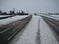
 The A4104 in the snow - geograph.org.uk - 1656948.jpg 640 × 427; 270 KB
-
 The A4104 near Hancocks Lane - geograph.org.uk - 960984.jpg 640 × 436; 273 KB
-
 The Anchor Inn, Hook Common - geograph.org.uk - 655083.jpg 640 × 480; 79 KB
-
 The bend in the A4104 at Little Malvern - geograph.org.uk - 842365.jpg 640 × 427; 308 KB
-
 The Defford Arms - geograph.org.uk - 209495.jpg 640 × 480; 114 KB
-
 The District of Wychavon - geograph.org.uk - 521531.jpg 640 × 426; 104 KB
-
 The Dog in Baughton - geograph.org.uk - 737980.jpg 640 × 426; 62 KB
-
 The Marlbank pub. - geograph.org.uk - 1775553.jpg 640 × 360; 66 KB
-
 The Marlbank, Welland - geograph.org.uk - 1077165.jpg 640 × 426; 67 KB
-
 The Moorings, Lower Hook - geograph.org.uk - 1171259.jpg 640 × 427; 257 KB
-
 The Pheasant Inn - geograph.org.uk - 754811.jpg 640 × 480; 64 KB
-
 The route of the old A4104 - geograph.org.uk - 785452.jpg 640 × 426; 69 KB
-
 Tunnel Hill - the way west - geograph.org.uk - 836340.jpg 640 × 480; 80 KB
-
 Tunnel Hill junction - geograph.org.uk - 836330.jpg 640 × 480; 108 KB
-
 UK road A4104.PNG 597 × 184; 7 KB
-
 Upper Welland turn - geograph.org.uk - 838862.jpg 640 × 480; 71 KB
-
 Upton Bridge - geograph.org.uk - 1359126.jpg 640 × 427; 281 KB
-
 Upton Milestone - geograph.org.uk - 610994.jpg 480 × 640; 88 KB
-
 Upton-on-Severn northward into town on A4104 1724333 1474ed7c.jpg 640 × 387; 145 KB
-
 Victims of the flood, Upton-upon-Severn - geograph.org.uk - 514863.jpg 640 × 426; 104 KB
-
 Welcome to Wychavon - geograph.org.uk - 1766622.jpg 640 × 427; 253 KB
-
 Welland crossroads - geograph.org.uk - 1293843.jpg 640 × 480; 252 KB
-
 Welland Road - geograph.org.uk - 1615957.jpg 640 × 480; 100 KB
-
 Wheat by the A4104 - geograph.org.uk - 856335.jpg 640 × 427; 292 KB
-
 A tale in the tarmac - geograph.org.uk - 1171268.jpg 640 × 427; 269 KB
-
 A4104 at Little Malvern Priory - geograph.org.uk - 754068.jpg 640 × 480; 80 KB
-
 A4104 from Hancocks Lane junction (1) - geograph.org.uk - 823149.jpg 640 × 480; 77 KB
-
 A4104 from Hancocks Lane junction (2) - geograph.org.uk - 823173.jpg 640 × 480; 62 KB
-
 Hermit's Corner - geograph.org.uk - 778008.jpg 640 × 427; 233 KB
-

-
 Marlbank Farm, Welland - geograph.org.uk - 427265.jpg 640 × 427; 207 KB
-
 Marsh Common - geograph.org.uk - 4344.jpg 640 × 480; 91 KB
-
 Mayalls Farm from the A4104 - geograph.org.uk - 643473.jpg 640 × 427; 244 KB
-
 Road Over the Flood - geograph.org.uk - 292070.jpg 640 × 427; 233 KB
-
 The Entrance to Watery Lane - geograph.org.uk - 447851.jpg 640 × 302; 189 KB
-
 The Road to Little Malvern - geograph.org.uk - 596254.jpg 640 × 399; 152 KB


_-_geograph.org.uk_-_823149.jpg)
_-_geograph.org.uk_-_823173.jpg)


