Category:A Set of Twenty New and Correct Maps of Ireland
Media in category "A Set of Twenty New and Correct Maps of Ireland"
The following 19 files are in this category, out of 19 total.
-

-
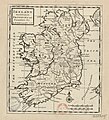 Ireland Divided into Its Provinces and Counties &c (btv1b53056672w).jpg 3,458 × 3,820; 1.95 MB
-
-

-
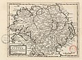
 The Counties of Antrim, Ardmagh and Down - By H. Moll Geographer - btv1b530565786.jpg 2,816 × 3,520; 1.6 MB
-

-

-
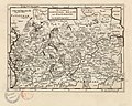 The Counties of Longford, Meath and Eastmeath - By H. Moll Geographer - btv1b530565623.jpg 3,656 × 2,936; 1.63 MB
-
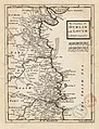 The Counties of Dublin and Louth - By H. Moll Geographer - btv1b53056651m.jpg 2,696 × 3,536; 1.51 MB
-

-

-

-
 The Counties of Sligoe and Mayo - By H. Moll Geographer - btv1b530561688.jpg 3,424 × 2,768; 1.65 MB
-
 The County of Rosscommon - By H. Moll Geographer - btv1b53056423h.jpg 2,728 × 3,424; 1.33 MB
-
 The Counties of Gallway - By H. Moll Geographer - btv1b53056434c.jpg 3,480 × 2,768; 1.68 MB
-
 The Counties of Clare and Limerick - By H. Moll Geographer - btv1b53056962m.jpg 3,624 × 2,704; 1.55 MB
-

-
-

.jpg)


_-_btv1b530564830.jpg)