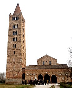
Category:Abbazia di Pomposa
| Object location | | View all coordinates using: OpenStreetMap |
|---|
church in Pomposa - Codigoro (FE) | |||||
| Upload media | |||||
| Instance of |
| ||||
|---|---|---|---|---|---|
| Location | Codigoro, Province of Ferrara, Emilia-Romagna, Italy | ||||
| Street address |
| ||||
| Architectural style | |||||
| Diocese | |||||
| Headquarters location | |||||
| Has part(s) | |||||
| Heritage designation | |||||
| Inception |
| ||||
| Area |
| ||||
| Religion or worldview | |||||
| Visitors per year |
| ||||
| official website | |||||
 | |||||
Subcategories
This category has the following 10 subcategories, out of 10 total.
- Abbazia di Pomposa in art (4 F)
- Abbazia di Pomposa - Entry (6 F)
A
B
- Abbazia di Pomposa - Belltower (63 F)
C
M
R
Pages in category "Abbazia di Pomposa"
This category contains only the following page.
Media in category "Abbazia di Pomposa"
The following 29 files are in this category, out of 29 total.
-
Abbazia di Pomposa - Cloister.JPG 2,048 × 1,536; 1.28 MB
-
Abbazia di Pomposa - Italia (28340368213).jpg 3,216 × 4,288; 3.22 MB
-
Abbazia di Pomposa - Italia (28340370143).jpg 4,288 × 3,216; 3.16 MB
-
Abbazia di Pomposa - panoramio.jpg 1,944 × 1,296; 467 KB
-
Abbazia di Pomposa.JPG 317 × 471; 24 KB
-
Abbazia di Pomposa14.jpg 1,920 × 1,080; 1.05 MB
-
Abbazia Pomposa.jpg 1,960 × 4,032; 2.91 MB
-
Codigoro, abbazia di Pomposa (01) (cropped).jpg 4,535 × 3,025; 5.87 MB
-
Codigoro, abbazia di Pomposa (01).jpg 5,007 × 3,338; 6.83 MB
-
Codigoro, abbazia di Pomposa (02).jpg 5,184 × 3,456; 7.07 MB
-
Codigoro, abbazia di Pomposa (03).jpg 5,184 × 3,456; 7.54 MB
-
Codigoro, abbazia di Pomposa (04).jpg 5,184 × 3,456; 6.98 MB
-
Codigoro, abbazia di Pomposa (05).jpg 5,002 × 3,335; 5.71 MB
-
Codigoro, abbazia di Pomposa (21).jpg 5,184 × 3,456; 5.73 MB
-
Codigoro, abbazia di Pomposa (22).jpg 5,184 × 3,456; 7.76 MB
-
Codigoro, abbazia di Pomposa (23).jpg 5,184 × 3,456; 8.08 MB
-
Codigoro, abbazia di Pomposa (24).jpg 4,394 × 2,929; 5.22 MB
-
Codigoro, abbazia di Pomposa (25).jpg 5,184 × 3,456; 9.1 MB
-
Codigoro, abbazia di Pomposa (26).jpg 5,184 × 3,456; 7.95 MB
-
Codigoro, abbazia di Pomposa (32).jpg 5,184 × 3,456; 7.53 MB
-
Codigoro, abbazia di Pomposa (44).jpg 4,875 × 3,250; 5.09 MB
-
Complesso della basilica di Pomposa, visto dai campi retrostanti - panoramio.jpg 5,018 × 2,508; 1.94 MB
-
Dall arco.jpg 1,180 × 1,838; 498 KB
-
Murales IAT Abbazia di Pomposa 0.jpg 3,539 × 3,351; 2.35 MB
-
Murales IAT Abbazia di Pomposa.jpg 3,264 × 2,448; 1.23 MB
-
Pomposa, abbazia, cortile 01.jpg 3,456 × 2,304; 6.51 MB
-
Pomposa, particolare della basilica - panoramio.jpg 5,009 × 3,272; 2.57 MB
-
Ponte, Abbazia di Pomposa.jpg 6,000 × 4,000; 6.22 MB
-
View of the Pomposa's Abbey.jpg 1,960 × 4,032; 4.13 MB


