Category:Acheregg
 | |||||
| Upload media | |||||
| Instance of | |||||
|---|---|---|---|---|---|
| Location | |||||
 | |||||
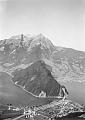
Deutsch: Die Acheregg ist eine Stelle bzw. das Ufergebiet an dem östlichen Ende des Bergrückens des Loppers, westlich von Stansstad
Media in category "Acheregg"
The following 16 files are in this category, out of 16 total.
-
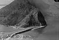 ETH-BIB Com F65-04753 Achereggbruecke 310365.jpg 3,072 × 2,109; 790 KB
-
 ETH-BIB-Stansstad, Achereggbrücke-LBS H1-024413.tif 8,116 × 5,671; 131.72 MB
-
 ETH-BIB-Stansstad, Achereggbrücke-LBS H1-024414.tif 8,165 × 5,678; 132.67 MB
-
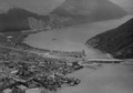 ETH-BIB-Stansstad, Achereggbrücke-LBS H1-024415.tif 8,119 × 5,689; 132.18 MB
-
 ETH-BIB-Stansstad, Acherggmühle-LBS H1-026867.tif 6,005 × 8,477; 145.68 MB
-
 ETH-BIB-Stansstad, Hotel Acheregg, Achereggbrücke-LBS H1-024419.tif 8,108 × 5,703; 132.33 MB
-
 ETH-BIB-Stansstad, Hotel Acheregg-LBS H1-024416.tif 8,127 × 5,646; 131.32 MB
-
 ETH-BIB-Stansstad, Hotel Acheregg-LBS H1-024417.tif 8,032 × 5,690; 130.79 MB
-
 ETH-BIB-Stansstad, Hotel Acheregg-LBS H1-024418.tif 8,036 × 5,634; 129.57 MB
-
 ETH-BIB-Steinbruch, Achernbrücke bei Stansstaad (Hauterivian)-Dia 247-09358.tif 3,658 × 2,751; 9.71 MB
-
 Lopperbrücke 1907-1908.jpg 1,654 × 2,262; 566 KB
-
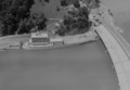
 Picswiss NW-25-20.jpg 500 × 333; 37 KB
-
Steamer Unterwalden passing Acheregg bridge 2011.ogv 1 min 1 s, 1,280 × 720; 70.19 MB
-
 Switzerland-03565 - Seerose (23483616303).jpg 6,069 × 4,105; 17.39 MB
-
 Unterwalden 2011 4.jpg 3,264 × 2,448; 2.07 MB
-
 Wegweiser Acheregg 436.JPG 3,456 × 2,592; 1.55 MB


.jpg)

