Category:Achter de Dom 7, Utrecht
| Object location | | View all coordinates using: OpenStreetMap |
|---|
 | |||||
| Upload media | |||||
| Instance of | |||||
|---|---|---|---|---|---|
| Location | Utrecht, Netherlands | ||||
| Located on street |
| ||||
| Owned by | |||||
| Heritage designation |
| ||||
 | |||||
|
This is a category about rijksmonument number 35976
|
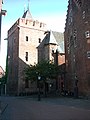
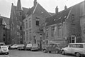
English: This tower-shaped building of the 14th century is one of the two rijksmonumenten (national heritage monuments) with the adress Achter de Dom 7 in 3512 JN Utrecht, Netherlands, probably originally the chapter house of Oudmunster church.
The other one is rijksmonument n°. 36076, built in the 15th century and housing the great autitory of the university, see Category:Kapittelzaal, Utrecht
The other one is rijksmonument n°. 36076, built in the 15th century and housing the great autitory of the university, see Category:Kapittelzaal, Utrecht
Media in category "Achter de Dom 7, Utrecht"
The following 17 files are in this category, out of 17 total.
-
 35976-Kapittelhuis, Achter de Dom 7.jpg 5,061 × 3,456; 8.78 MB
-
 Achter de Dom 7.JPG 2,592 × 3,456; 4.2 MB
-
 Exterieur - Utrecht - 20235361 - RCE.jpg 872 × 1,200; 167 KB
-
 Exterieur - Utrecht - 20235362 - RCE.jpg 871 × 1,200; 228 KB
-
 Exterieur - Utrecht - 20235363 - RCE.jpg 880 × 1,200; 176 KB
-
 Exterieur OVERZICHT - Utrecht - 20314729 - RCE.jpg 957 × 1,200; 225 KB
-
 Exterieur OVERZICHT - Utrecht - 20314730 - RCE.jpg 955 × 1,200; 266 KB
-
 Exterieur ZUIDGEVEL - Utrecht - 20314731 - RCE.jpg 1,200 × 950; 283 KB
-
 Gedeelte gevel, metselwerk, detail - Utrecht - 20320259 - RCE.jpg 1,200 × 783; 296 KB
-
 P1000835 Claustraal huis achter de Dom.jpg 3,240 × 4,320; 4.48 MB
-
 Pausdambrug 360-7.JPG 3,456 × 5,184; 6.78 MB
-

-

-
 Universiteitsaula oost-gevel aan de Achter de Dom - Utrecht - 20212582 - RCE.jpg 970 × 1,200; 225 KB
-
 Utrecht 010.jpg 960 × 1,280; 283 KB
-
 Voorgevel - Utrecht - 20235360 - RCE.jpg 805 × 1,200; 163 KB
-
 Voorgevels - Utrecht - 20235358 - RCE.jpg 1,200 × 802; 146 KB


