Category:Achterstraat 88, Vianen
| Object location | | View all coordinates using: OpenStreetMap |
|---|
| Address |
|
|
This is a category about rijksmonument number 37250
|
house in Vianen, Netherlands  | |||||
| Upload media | |||||
| Instance of | |||||
|---|---|---|---|---|---|
| Location | Vianen, Vijfheerenlanden, Utrecht, Netherlands | ||||
| Street address |
| ||||
| Located on street |
| ||||
| Owned by |
| ||||
| Heritage designation |
| ||||
| Inception |
| ||||
 | |||||
Media in category "Achterstraat 88, Vianen"
The following 9 files are in this category, out of 9 total.
-
 Achtergevel - Vianen - 20336059 - RCE.jpg 1,200 × 1,197; 398 KB
-
 Achtergevel geheel uitwendig - Vianen - 20241917 - RCE.jpg 1,200 × 940; 289 KB
-
 Achtergevel ter hoogte van verdieping inwendig - Vianen - 20241921 - RCE.jpg 1,200 × 960; 335 KB
-
 Achtergevel ter hoogte van verdieping inwendig - Vianen - 20241922 - RCE.jpg 1,200 × 945; 311 KB
-
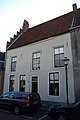 Vianen - Achterstraat 88 - Rijksmonument 37250.JPG 2,592 × 3,872; 2.94 MB
-
 Voorgevel - Vianen - 20336058 - RCE.jpg 964 × 1,200; 233 KB
-
 Voorgevels - Vianen - 20241916 - RCE.jpg 1,188 × 1,200; 290 KB
-
 Zuid zijgevel onder binnendak - Vianen - 20241920 - RCE.jpg 1,200 × 954; 264 KB
-
 Zuid zijgevel zolder en binnendak - Vianen - 20241919 - RCE.jpg 1,200 × 960; 317 KB


