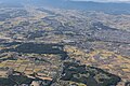
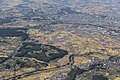
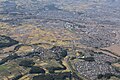
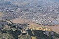
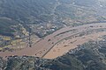
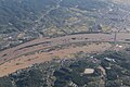
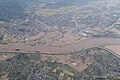
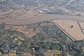
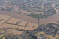
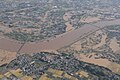
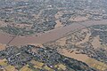
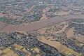
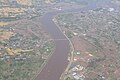
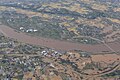
Category:Aerial photographs of 2019 Abukuma River flood by GSI
Media in category "Aerial photographs of 2019 Abukuma River flood by GSI"
The following 200 files are in this category, out of 1,367 total.
(previous page) (next page)-
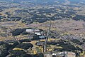
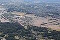
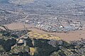
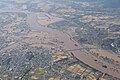
 Aerial photographs of 2019 Abukuma River flood by GSI - 001.jpg 1,368 × 912; 1.03 MB
-
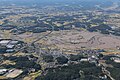
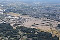
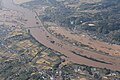
 Aerial photographs of 2019 Abukuma River flood by GSI - 002.jpg 1,368 × 912; 1.02 MB
-
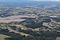
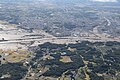
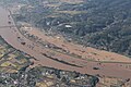
 Aerial photographs of 2019 Abukuma River flood by GSI - 003.jpg 1,368 × 912; 1.01 MB
-
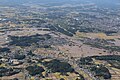
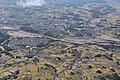
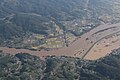
 Aerial photographs of 2019 Abukuma River flood by GSI - 004.jpg 1,368 × 912; 1.01 MB
-
 Aerial photographs of 2019 Abukuma River flood by GSI - 005.jpg 1,368 × 912; 1,014 KB
-
 Aerial photographs of 2019 Abukuma River flood by GSI - 006.jpg 1,368 × 912; 987 KB
-
 Aerial photographs of 2019 Abukuma River flood by GSI - 007.jpg 1,368 × 912; 979 KB
-
 Aerial photographs of 2019 Abukuma River flood by GSI - 008.jpg 1,368 × 912; 955 KB
-
 Aerial photographs of 2019 Abukuma River flood by GSI - 009.jpg 1,368 × 912; 932 KB
-
 Aerial photographs of 2019 Abukuma River flood by GSI - 010.jpg 1,368 × 912; 923 KB
-
 Aerial photographs of 2019 Abukuma River flood by GSI - 011.jpg 1,368 × 912; 906 KB
-
 Aerial photographs of 2019 Abukuma River flood by GSI - 012.jpg 1,368 × 912; 939 KB
-
 Aerial photographs of 2019 Abukuma River flood by GSI - 013.jpg 1,368 × 912; 913 KB
-
 Aerial photographs of 2019 Abukuma River flood by GSI - 014.jpg 1,368 × 912; 930 KB
-
 Aerial photographs of 2019 Abukuma River flood by GSI - 015.jpg 1,368 × 912; 917 KB
-
 Aerial photographs of 2019 Abukuma River flood by GSI - 016.jpg 1,368 × 912; 907 KB
-
 Aerial photographs of 2019 Abukuma River flood by GSI - 017.jpg 1,368 × 912; 915 KB
-
 Aerial photographs of 2019 Abukuma River flood by GSI - 018.jpg 1,368 × 912; 922 KB
-
 Aerial photographs of 2019 Abukuma River flood by GSI - 019.jpg 1,368 × 912; 937 KB
-
 Aerial photographs of 2019 Abukuma River flood by GSI - 020.jpg 1,368 × 912; 935 KB
-
 Aerial photographs of 2019 Abukuma River flood by GSI - 021.jpg 1,368 × 912; 942 KB
-
 Aerial photographs of 2019 Abukuma River flood by GSI - 022.jpg 1,368 × 912; 975 KB
-
 Aerial photographs of 2019 Abukuma River flood by GSI - 023.jpg 1,368 × 912; 982 KB
-
 Aerial photographs of 2019 Abukuma River flood by GSI - 024.jpg 1,368 × 912; 972 KB
-
 Aerial photographs of 2019 Abukuma River flood by GSI - 025.jpg 1,368 × 912; 973 KB
-
 Aerial photographs of 2019 Abukuma River flood by GSI - 026.jpg 1,368 × 912; 974 KB
-
 Aerial photographs of 2019 Abukuma River flood by GSI - 027.jpg 1,368 × 912; 985 KB
-
 Aerial photographs of 2019 Abukuma River flood by GSI - 028.jpg 1,368 × 912; 986 KB
-
 Aerial photographs of 2019 Abukuma River flood by GSI - 029.jpg 1,368 × 912; 955 KB
-
 Aerial photographs of 2019 Abukuma River flood by GSI - 030.jpg 1,368 × 912; 987 KB
-
 Aerial photographs of 2019 Abukuma River flood by GSI - 031.jpg 1,368 × 912; 1,015 KB
-
 Aerial photographs of 2019 Abukuma River flood by GSI - 032.jpg 1,368 × 912; 1,011 KB
-
 Aerial photographs of 2019 Abukuma River flood by GSI - 033.jpg 1,368 × 912; 1,001 KB
-
 Aerial photographs of 2019 Abukuma River flood by GSI - 034.jpg 1,368 × 912; 1,003 KB
-
 Aerial photographs of 2019 Abukuma River flood by GSI - 035.jpg 1,368 × 912; 1,009 KB
-
 Aerial photographs of 2019 Abukuma River flood by GSI - 036.jpg 1,368 × 912; 990 KB
-
 Aerial photographs of 2019 Abukuma River flood by GSI - 037.jpg 1,368 × 912; 1,019 KB
-
 Aerial photographs of 2019 Abukuma River flood by GSI - 038.jpg 1,368 × 912; 1.02 MB
-
 Aerial photographs of 2019 Abukuma River flood by GSI - 039.jpg 1,368 × 912; 1.02 MB
-
 Aerial photographs of 2019 Abukuma River flood by GSI - 040.jpg 1,368 × 912; 1.01 MB
-
 Aerial photographs of 2019 Abukuma River flood by GSI - 041.jpg 1,368 × 912; 1.02 MB
-
 Aerial photographs of 2019 Abukuma River flood by GSI - 042.jpg 1,368 × 912; 1,015 KB
-
 Aerial photographs of 2019 Abukuma River flood by GSI - 043.jpg 1,368 × 912; 1,004 KB
-
 Aerial photographs of 2019 Abukuma River flood by GSI - 044.jpg 1,368 × 912; 980 KB
-
 Aerial photographs of 2019 Abukuma River flood by GSI - 045.jpg 1,368 × 912; 970 KB
-
 Aerial photographs of 2019 Abukuma River flood by GSI - 046.jpg 1,368 × 912; 941 KB
-
 Aerial photographs of 2019 Abukuma River flood by GSI - 047.jpg 1,368 × 912; 1,003 KB
-
 Aerial photographs of 2019 Abukuma River flood by GSI - 048.jpg 1,368 × 912; 996 KB
-
 Aerial photographs of 2019 Abukuma River flood by GSI - 049.jpg 1,368 × 912; 983 KB
-
 Aerial photographs of 2019 Abukuma River flood by GSI - 050.jpg 1,368 × 912; 990 KB
-
 Aerial photographs of 2019 Abukuma River flood by GSI - 051.jpg 1,368 × 912; 974 KB
-
 Aerial photographs of 2019 Abukuma River flood by GSI - 052.jpg 1,368 × 912; 974 KB
-
 Aerial photographs of 2019 Abukuma River flood by GSI - 053.jpg 1,368 × 912; 977 KB
-
 Aerial photographs of 2019 Abukuma River flood by GSI - 054.jpg 1,368 × 912; 951 KB
-
 Aerial photographs of 2019 Abukuma River flood by GSI - 055.jpg 1,368 × 912; 969 KB
-
 Aerial photographs of 2019 Abukuma River flood by GSI - 056.jpg 1,368 × 912; 967 KB
-
 Aerial photographs of 2019 Abukuma River flood by GSI - 057.jpg 1,368 × 912; 990 KB
-
 Aerial photographs of 2019 Abukuma River flood by GSI - 058.jpg 1,368 × 912; 982 KB
-
 Aerial photographs of 2019 Abukuma River flood by GSI - 059.jpg 1,368 × 912; 994 KB
-
 Aerial photographs of 2019 Abukuma River flood by GSI - 060.jpg 1,368 × 912; 1,000 KB
-
 Aerial photographs of 2019 Abukuma River flood by GSI - 061.jpg 1,368 × 912; 973 KB
-
 Aerial photographs of 2019 Abukuma River flood by GSI - 062.jpg 1,368 × 912; 882 KB
-
 Aerial photographs of 2019 Abukuma River flood by GSI - 063.jpg 1,368 × 912; 956 KB
-
 Aerial photographs of 2019 Abukuma River flood by GSI - 064.jpg 1,368 × 912; 962 KB
-
 Aerial photographs of 2019 Abukuma River flood by GSI - 065.jpg 1,368 × 912; 967 KB
-
 Aerial photographs of 2019 Abukuma River flood by GSI - 066.jpg 1,368 × 912; 986 KB
-
 Aerial photographs of 2019 Abukuma River flood by GSI - 067.jpg 1,368 × 912; 945 KB
-
 Aerial photographs of 2019 Abukuma River flood by GSI - 068.jpg 1,368 × 912; 926 KB
-
 Aerial photographs of 2019 Abukuma River flood by GSI - 069.jpg 1,368 × 912; 882 KB
-
 Aerial photographs of 2019 Abukuma River flood by GSI - 070.jpg 1,368 × 912; 866 KB
-
 Aerial photographs of 2019 Abukuma River flood by GSI - 071.jpg 1,368 × 912; 899 KB
-
 Aerial photographs of 2019 Abukuma River flood by GSI - 072.jpg 1,368 × 912; 921 KB
-
 Aerial photographs of 2019 Abukuma River flood by GSI - 073.jpg 1,368 × 912; 983 KB
-
 Aerial photographs of 2019 Abukuma River flood by GSI - 074.jpg 1,368 × 912; 1.02 MB
-
 Aerial photographs of 2019 Abukuma River flood by GSI - 075.jpg 1,368 × 912; 1 MB
-
 Aerial photographs of 2019 Abukuma River flood by GSI - 076.jpg 1,368 × 912; 999 KB
-
 Aerial photographs of 2019 Abukuma River flood by GSI - 077.jpg 1,368 × 912; 990 KB
-
 Aerial photographs of 2019 Abukuma River flood by GSI - 078.jpg 1,368 × 912; 1,000 KB
-
 Aerial photographs of 2019 Abukuma River flood by GSI - 079.jpg 1,368 × 912; 972 KB
-
 Aerial photographs of 2019 Abukuma River flood by GSI - 080.jpg 1,368 × 912; 987 KB
-
 Aerial photographs of 2019 Abukuma River flood by GSI - 081.jpg 1,368 × 912; 1.06 MB
-
 Aerial photographs of 2019 Abukuma River flood by GSI - 082.jpg 1,368 × 912; 1.06 MB
-
 Aerial photographs of 2019 Abukuma River flood by GSI - 083.jpg 1,368 × 912; 1.04 MB
-
 Aerial photographs of 2019 Abukuma River flood by GSI - 084.jpg 1,368 × 912; 1.03 MB
-
 Aerial photographs of 2019 Abukuma River flood by GSI - 085.jpg 1,368 × 912; 1.01 MB
-
 Aerial photographs of 2019 Abukuma River flood by GSI - 086.jpg 1,368 × 912; 1.04 MB
-
 Aerial photographs of 2019 Abukuma River flood by GSI - 087.jpg 1,368 × 912; 1.05 MB
-
 Aerial photographs of 2019 Abukuma River flood by GSI - 088.jpg 1,368 × 912; 1.07 MB
-
 Aerial photographs of 2019 Abukuma River flood by GSI - 089.jpg 1,368 × 912; 1.07 MB
-
 Aerial photographs of 2019 Abukuma River flood by GSI - 090.jpg 1,368 × 912; 1.07 MB
-
 Aerial photographs of 2019 Abukuma River flood by GSI - 091.jpg 1,368 × 912; 1.06 MB
-
 Aerial photographs of 2019 Abukuma River flood by GSI - 092.jpg 1,368 × 912; 1.07 MB
-
 Aerial photographs of 2019 Abukuma River flood by GSI - 093.jpg 1,368 × 912; 1.07 MB
-
 Aerial photographs of 2019 Abukuma River flood by GSI - 094.jpg 1,368 × 912; 1.06 MB
-
 Aerial photographs of 2019 Abukuma River flood by GSI - 095.jpg 1,368 × 912; 1.04 MB
-
 Aerial photographs of 2019 Abukuma River flood by GSI - 096.jpg 1,368 × 912; 1.04 MB
-
 Aerial photographs of 2019 Abukuma River flood by GSI - 097.jpg 1,368 × 912; 1.04 MB
-
 Aerial photographs of 2019 Abukuma River flood by GSI - 098.jpg 1,368 × 912; 1.04 MB
-
 Aerial photographs of 2019 Abukuma River flood by GSI - 099.jpg 1,368 × 912; 1.03 MB
-
 Aerial photographs of 2019 Abukuma River flood by GSI - 667.jpg 1,368 × 912; 969 KB
-
 Aerial photographs of 2019 Abukuma River flood by GSI - KUNIMI 001.jpg 1,368 × 912; 881 KB
-
 Aerial photographs of 2019 Abukuma River flood by GSI - KUNIMI 002.jpg 1,368 × 912; 899 KB
-
 Aerial photographs of 2019 Abukuma River flood by GSI - KUNIMI 003.jpg 1,368 × 912; 883 KB
-
 Aerial photographs of 2019 Abukuma River flood by GSI - KUNIMI 004.jpg 1,368 × 912; 830 KB
-
 Aerial photographs of 2019 Abukuma River flood by GSI - KUNIMI 005.jpg 1,368 × 912; 855 KB
-
 Aerial photographs of 2019 Abukuma River flood by GSI - KUNIMI 006.jpg 1,368 × 912; 873 KB
-
 Aerial photographs of 2019 Abukuma River flood by GSI - KUNIMI 007.jpg 1,368 × 912; 878 KB
-
 Aerial photographs of 2019 Abukuma River flood by GSI - KUNIMI 008.jpg 1,368 × 912; 892 KB
-
 Aerial photographs of 2019 Abukuma River flood by GSI - KUNIMI 009.jpg 1,368 × 912; 902 KB
-
 Aerial photographs of 2019 Abukuma River flood by GSI - KUNIMI 010.jpg 1,368 × 912; 874 KB
-
 Aerial photographs of 2019 Abukuma River flood by GSI - KUNIMI 011.jpg 1,368 × 912; 881 KB
-
 Aerial photographs of 2019 Abukuma River flood by GSI - KUNIMI 012.jpg 1,368 × 912; 876 KB
-
 Aerial photographs of 2019 Abukuma River flood by GSI - KUNIMI 013.jpg 1,368 × 912; 826 KB
-
 Aerial photographs of 2019 Abukuma River flood by GSI - KUNIMI 014.jpg 1,368 × 912; 869 KB
-
 Aerial photographs of 2019 Abukuma River flood by GSI - KUNIMI 015.jpg 1,368 × 912; 869 KB
-
 Aerial photographs of 2019 Abukuma River flood by GSI - KUNIMI 016.jpg 1,368 × 912; 848 KB
-
 Aerial photographs of 2019 Abukuma River flood by GSI - KUNIMI 017.jpg 1,368 × 912; 854 KB
-
 Aerial photographs of 2019 Abukuma River flood by GSI - KUNIMI 018.jpg 1,368 × 912; 850 KB
-
 Aerial photographs of 2019 Abukuma River flood by GSI - KUNIMI 019.jpg 1,368 × 912; 803 KB
-
 Aerial photographs of 2019 Abukuma River flood by GSI - KUNIMI 020.jpg 1,368 × 912; 745 KB
-
 Aerial photographs of 2019 Abukuma River flood by GSI - KUNIMI 021.jpg 1,368 × 912; 761 KB
-
 Aerial photographs of 2019 Abukuma River flood by GSI - KUNIMI 022.jpg 1,368 × 912; 725 KB
-
 Aerial photographs of 2019 Abukuma River flood by GSI - KUNIMI 023.jpg 1,368 × 912; 802 KB
-
 Aerial photographs of 2019 Abukuma River flood by GSI - KUNIMI 024.jpg 1,368 × 912; 782 KB
-
 Aerial photographs of 2019 Abukuma River flood by GSI - KUNIMI 025.jpg 1,368 × 912; 771 KB
-
 Aerial photographs of 2019 Abukuma River flood by GSI - KUNIMI 026.jpg 1,368 × 912; 784 KB
-
 Aerial photographs of 2019 Abukuma River flood by GSI - KUNIMI 027.jpg 1,368 × 912; 815 KB
-
 Aerial photographs of 2019 Abukuma River flood by GSI - KUNIMI 028.jpg 1,368 × 912; 806 KB
-
 Aerial photographs of 2019 Abukuma River flood by GSI - KUNIMI 029.jpg 1,368 × 912; 801 KB
-
 Aerial photographs of 2019 Abukuma River flood by GSI - KUNIMI 030.jpg 1,368 × 912; 829 KB
-
 Aerial photographs of 2019 Abukuma River flood by GSI - KUNIMI 031.jpg 1,368 × 912; 827 KB
-
 Aerial photographs of 2019 Abukuma River flood by GSI - KUNIMI 032.jpg 1,368 × 912; 826 KB
-
 Aerial photographs of 2019 Abukuma River flood by GSI - KUNIMI 033.jpg 1,368 × 912; 844 KB
-
 Aerial photographs of 2019 Abukuma River flood by GSI - KUNIMI 034.jpg 1,368 × 912; 851 KB
-
 Aerial photographs of 2019 Abukuma River flood by GSI - KUNIMI 035.jpg 1,368 × 912; 880 KB
-
 Aerial photographs of 2019 Abukuma River flood by GSI - KUNIMI 036.jpg 1,368 × 912; 844 KB
-
 Aerial photographs of 2019 Abukuma River flood by GSI - KUNIMI 037.jpg 1,368 × 912; 850 KB
-
 Aerial photographs of 2019 Abukuma River flood by GSI - KUNIMI 038.jpg 1,368 × 912; 856 KB
-
 Aerial photographs of 2019 Abukuma River flood by GSI - KUNIMI 039.jpg 1,368 × 912; 872 KB
-
 Aerial photographs of 2019 Abukuma River flood by GSI - KUNIMI 040.jpg 1,368 × 912; 880 KB
-
 Aerial photographs of 2019 Abukuma River flood by GSI - KUNIMI 041.jpg 1,368 × 912; 867 KB
-
 Aerial photographs of 2019 Abukuma River flood by GSI - KUNIMI 042.jpg 1,368 × 912; 870 KB
-
 Aerial photographs of 2019 Abukuma River flood by GSI - KUNIMI 043.jpg 1,368 × 912; 888 KB
-
 Aerial photographs of 2019 Abukuma River flood by GSI - KUNIMI 044.jpg 1,368 × 912; 868 KB
-
 Aerial photographs of 2019 Abukuma River flood by GSI - KUNIMI 045.jpg 1,368 × 912; 896 KB
-
 Aerial photographs of 2019 Abukuma River flood by GSI - KUNIMI 046.jpg 1,368 × 912; 866 KB
-
 Aerial photographs of 2019 Abukuma River flood by GSI - KUNIMI 047.jpg 1,368 × 912; 866 KB
-
 Aerial photographs of 2019 Abukuma River flood by GSI - KUNIMI 048.jpg 1,368 × 912; 864 KB
-
 Aerial photographs of 2019 Abukuma River flood by GSI - KUNIMI 049.jpg 1,368 × 912; 854 KB
-
 Aerial photographs of 2019 Abukuma River flood by GSI - KUNIMI 050.jpg 1,368 × 912; 851 KB
-
 Aerial photographs of 2019 Abukuma River flood by GSI - KUNIMI 051.jpg 1,368 × 912; 854 KB
-
 Aerial photographs of 2019 Abukuma River flood by GSI - KUNIMI 052.jpg 1,368 × 912; 852 KB
-
 Aerial photographs of 2019 Abukuma River flood by GSI - KUNIMI 053.jpg 1,368 × 912; 845 KB
-
 Aerial photographs of 2019 Abukuma River flood by GSI - KUNIMI 054.jpg 1,368 × 912; 850 KB
-
 Aerial photographs of 2019 Abukuma River flood by GSI - KUNIMI 055.jpg 1,368 × 912; 843 KB
-
 Aerial photographs of 2019 Abukuma River flood by GSI - KUNIMI 056.jpg 1,368 × 912; 849 KB
-
 Aerial photographs of 2019 Abukuma River flood by GSI - KUNIMI 057.jpg 1,368 × 912; 848 KB
-
 Aerial photographs of 2019 Abukuma River flood by GSI - KUNIMI 058.jpg 1,368 × 912; 849 KB
-
 Aerial photographs of 2019 Abukuma River flood by GSI - KUNIMI 060.jpg 1,368 × 912; 839 KB
-
 Aerial photographs of 2019 Abukuma River flood by GSI - KUNIMI 062.jpg 1,368 × 912; 843 KB
-
 Aerial photographs of 2019 Abukuma River flood by GSI - KUNIMI 063.jpg 1,368 × 912; 853 KB
-
 Aerial photographs of 2019 Abukuma River flood by GSI - KUNIMI 064.jpg 1,368 × 912; 858 KB
-
 Aerial photographs of 2019 Abukuma River flood by GSI - KUNIMI 065.jpg 1,368 × 912; 877 KB
-
 Aerial photographs of 2019 Abukuma River flood by GSI - KUNIMI 066.jpg 1,368 × 912; 882 KB
-
 Aerial photographs of 2019 Abukuma River flood by GSI - KUNIMI 067.jpg 1,368 × 912; 888 KB
-
 Aerial photographs of 2019 Abukuma River flood by GSI - KUNIMI 068.jpg 1,368 × 912; 899 KB
-
 Aerial photographs of 2019 Abukuma River flood by GSI - KUNIMI 069.jpg 1,368 × 912; 901 KB
-
 Aerial photographs of 2019 Abukuma River flood by GSI - KUNIMI 070.jpg 1,368 × 912; 901 KB
-
 Aerial photographs of 2019 Abukuma River flood by GSI - KUNIMI 071.jpg 1,368 × 912; 912 KB
-
 Aerial photographs of 2019 Abukuma River flood by GSI - KUNIMI 072.jpg 1,368 × 912; 918 KB
-
 Aerial photographs of 2019 Abukuma River flood by GSI - KUNIMI 073.jpg 1,368 × 912; 918 KB
-
 Aerial photographs of 2019 Abukuma River flood by GSI - KUNIMI 074.jpg 1,368 × 912; 923 KB
-
 Aerial photographs of 2019 Abukuma River flood by GSI - KUNIMI 075.jpg 1,368 × 912; 911 KB
-
 Aerial photographs of 2019 Abukuma River flood by GSI - KUNIMI 076.jpg 1,368 × 912; 919 KB
-
 Aerial photographs of 2019 Abukuma River flood by GSI - KUNIMI 077.jpg 1,368 × 912; 919 KB
-
 Aerial photographs of 2019 Abukuma River flood by GSI - KUNIMI 078.jpg 1,368 × 912; 917 KB
-
 Aerial photographs of 2019 Abukuma River flood by GSI - KUNIMI 079.jpg 1,368 × 912; 907 KB
-
 Aerial photographs of 2019 Abukuma River flood by GSI - KUNIMI 080.jpg 1,368 × 912; 900 KB
-
 Aerial photographs of 2019 Abukuma River flood by GSI - KUNIMI 081.jpg 1,368 × 912; 896 KB
-
 Aerial photographs of 2019 Abukuma River flood by GSI - KUNIMI 082.jpg 1,368 × 912; 922 KB
-
 Aerial photographs of 2019 Abukuma River flood by GSI - KUNIMI 083.jpg 1,368 × 912; 947 KB
-
 Aerial photographs of 2019 Abukuma River flood by GSI - KUNIMI 084.jpg 1,368 × 912; 939 KB
-
 Aerial photographs of 2019 Abukuma River flood by GSI - KUNIMI 085.jpg 1,368 × 912; 925 KB
-
 Aerial photographs of 2019 Abukuma River flood by GSI - KUNIMI 086.jpg 1,368 × 912; 896 KB
-
 Aerial photographs of 2019 Abukuma River flood by GSI - KUNIMI 087.jpg 1,368 × 912; 881 KB
-
 Aerial photographs of 2019 Abukuma River flood by GSI - KUNIMI 088.jpg 1,368 × 912; 843 KB
-
 Aerial photographs of 2019 Abukuma River flood by GSI - KUNIMI 089.jpg 1,368 × 912; 825 KB
-
 Aerial photographs of 2019 Abukuma River flood by GSI - KUNIMI 090.jpg 1,368 × 912; 838 KB
-
 Aerial photographs of 2019 Abukuma River flood by GSI - KUNIMI 091.jpg 1,368 × 912; 847 KB
-
 Aerial photographs of 2019 Abukuma River flood by GSI - KUNIMI 092.jpg 1,368 × 912; 844 KB
-
 Aerial photographs of 2019 Abukuma River flood by GSI - KUNIMI 093.jpg 1,368 × 912; 828 KB
-
 Aerial photographs of 2019 Abukuma River flood by GSI - KUNIMI 094.jpg 1,368 × 912; 821 KB
-
 Aerial photographs of 2019 Abukuma River flood by GSI - KUNIMI 095.jpg 1,368 × 912; 806 KB
-
 Aerial photographs of 2019 Abukuma River flood by GSI - KUNIMI 096.jpg 1,368 × 912; 811 KB
-
 Aerial photographs of 2019 Abukuma River flood by GSI - KUNIMI 097.jpg 1,368 × 912; 805 KB
-
 Aerial photographs of 2019 Abukuma River flood by GSI - KUNIMI 098.jpg 1,368 × 912; 835 KB
-
 Aerial photographs of 2019 Abukuma River flood by GSI - KUNIMI 099.jpg 1,368 × 912; 870 KB
-
 Aerial photographs of 2019 Abukuma River flood by GSI - KUNIMI 100.jpg 1,368 × 912; 883 KB
-
 Aerial photographs of 2019 Abukuma River flood by GSI - KUNIMI 101.jpg 1,368 × 912; 905 KB
-
 Aerial photographs of 2019 Abukuma River flood by GSI - Maru100.jpg 1,368 × 912; 691 KB


