Category:Aerial photographs of Alb-Donau-Kreis
Urban districts (cities): Baden-Baden · Freiburg · Heidelberg · Heilbronn · Karlsruhe · Mannheim · Pforzheim · Stuttgart · Ulm
Deutsch: Luftbilder aus dem Alb-Donau-Kreis in Baden-Württemberg.
Media in category "Aerial photographs of Alb-Donau-Kreis"
The following 17 files are in this category, out of 17 total.
-
 Aerial image of the Blaubeuren airfield.jpg 5,000 × 3,400; 6.27 MB
-
 Aerial image of the Ehingen-Schlechtenfeld gliding site.jpg 4,200 × 3,500; 7.39 MB
-
 Aerial image of the Erbach airfield.jpg 4,700 × 3,100; 5.1 MB
-
 Aerial image of the Erbach Castle (view from the southeast).jpg 4,200 × 2,800; 4.16 MB
-
 Aerial image of the Laichingen airfield.jpg 4,600 × 3,680; 5.36 MB
-
 Aerial image of the Oppingen-Au gliding site.jpg 4,300 × 3,000; 5.72 MB
-

-
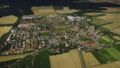 Beimerstetten.jpg 335 × 190; 32 KB
-
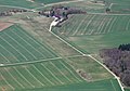
 Blaubeuren-Asch-20140719-1473.jpg 3,872 × 2,592; 4.85 MB
-
 Bohnacker luftbild werk d.jpg 568 × 278; 199 KB
-
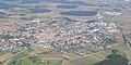 Laichingen 200209.jpg 2,000 × 1,000; 582 KB
-
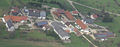 Luftbilder Aichen klein.jpg 800 × 315; 88 KB
-
 Luftbilder Nellingen klein.jpg 800 × 313; 109 KB
-
 Luftbilder Oppingen klein.jpg 800 × 219; 63 KB
-
 NBS-Wendlingen-Ulm-AlbabstiegstunnelLuftbild-20140719-1400.jpg 3,872 × 2,592; 4.95 MB
-
 NBS-Wendlingen-Ulm-TunnelWidderstallLuftbild-20140719-1197.jpg 3,872 × 2,592; 5.21 MB
-
 NBS-Wendlingen-Ulm-TunnelWidderstallLuftbild-20140719-1228.jpg 3,872 × 2,592; 4.69 MB


.jpg)


