Category:Aerial photographs of Greater Manchester
Ceremonial counties of England: Bedfordshire · Berkshire · Buckinghamshire · Cambridgeshire · Cheshire · Cornwall · Cumbria · Derbyshire · Devon · Dorset · Durham · East Riding of Yorkshire · East Sussex · Essex · Gloucestershire · Greater London · Greater Manchester · Hampshire · Herefordshire · Hertfordshire · Isle of Wight · Kent · Lancashire · Leicestershire · Lincolnshire · Merseyside · Norfolk · North Yorkshire · Northamptonshire · Northumberland · Nottinghamshire · Oxfordshire · Shropshire · Somerset · South Yorkshire · Staffordshire · Suffolk · Surrey · Tyne and Wear · Warwickshire · West Midlands · West Sussex · West Yorkshire · Wiltshire · Worcestershire
City-counties: Bristol · City of London
Former historic counties: Middlesex · Sussex · Yorkshire
Other former counties:
City-counties: Bristol · City of London
Former historic counties: Middlesex · Sussex · Yorkshire
Other former counties:

Subcategories
This category has the following 2 subcategories, out of 2 total.
Media in category "Aerial photographs of Greater Manchester"
The following 64 files are in this category, out of 64 total.
-
 Aerial photo of Peel Monument overlooking Holcombe and Bury.jpg 3,808 × 2,074; 5.26 MB
-
 Aerial photo of Sale Water Park taken on a summer evening.jpg 4,000 × 2,250; 3.45 MB
-
 Aerial photograph of Manchester city centre.jpg 759 × 539; 655 KB
-
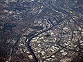
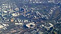
 Aerial photograph of Manchester, Salford and Trafford.jpg 2,048 × 1,536; 3.48 MB
-
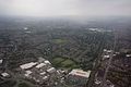
 Aerial photograph of north Manchester.jpg 2,048 × 1,536; 2.97 MB
-
 Aerial photograph of Salford and Trafford Park.jpg 2,048 × 1,536; 3.32 MB
-
 Aerial view of Elton Reservoir.jpg 4,257 × 3,193; 9.4 MB
-
 Aerial View of Scout Moor Wind Farm - geograph.org.uk - 777684.jpg 640 × 374; 74 KB
-

-
 Aerial View of Scout Moor Wind Farm.jpg 640 × 376; 225 KB
-
 Ashton under lyne aerial shot.jpg 3,488 × 2,003; 996 KB
-
 Barnes Hospital from the air (geograph 4032946).jpg 640 × 511; 209 KB
-
 Barton-upon-Irwell 11.05.02R.jpg 1,568 × 1,104; 156 KB
-
 BirdseyeViewPWCampus.jpg 1,424 × 1,071; 279 KB
-
 Bolton School aerialshot aug09.jpg 640 × 427; 168 KB
-
 Bolton School Campus.jpg 5,625 × 4,029; 12.3 MB
-
 Bolton School Quad.jpg 640 × 459; 108 KB
-
 Cheadle Hulme Station aerial.JPG 585 × 441; 64 KB
-
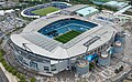
 City of Manchester Stadium 2023 cropped.jpg 4,500 × 3,000; 11.35 MB
-
 Denton greater manchester from the air.jpg 2,293 × 3,188; 927 KB
-
 Departing a snowy Manchester (8448104199).jpg 3,888 × 2,592; 3.98 MB
-
 Departing a snowy Manchester (8449180316).jpg 3,888 × 2,592; 3.74 MB
-
 Etihad Stadium and Sport City, Manchester, from the air (geograph 4887123).jpg 1,024 × 576; 113 KB
-
 Flying over the Styal Line - geograph.org.uk - 3284908.jpg 1,066 × 713; 136 KB
-
 Greater Manchester aerial photograph.jpg 2,048 × 1,365; 2.61 MB
-
 Greater Manchester Satelite View bright.png 992 × 653; 1.52 MB
-
 Greater Manchester Satelite View.png 992 × 653; 1.29 MB
-
 Heaton Chapel from the air - geograph.org.uk - 3445454.jpg 640 × 480; 146 KB
-
 Heaton moor aerial shot.jpg 3,340 × 2,226; 920 KB
-
 MAN Landing video (7863042000).jpg 1,280 × 720; 308 KB
-
 Manchester Airport aerial portrait.jpg 1,200 × 1,600; 767 KB
-
 Manchester Airport from the air - geograph.org.uk - 695853.jpg 640 × 480; 89 KB
-
 Manchester Airport, England from the air.jpg 2,814 × 1,734; 5.95 MB
-
 Manchester Airport.jpg 512 × 320; 227 KB
-
 Manchester city academy stadium.jpg 4,565 × 3,419; 12.2 MB
-
 Manchester city etihad campus.jpg 4,565 × 3,419; 11.5 MB
-
 Manchester city etihad stadium (cropped).jpg 3,097 × 1,915; 6.42 MB
-
 Manchester city etihad stadium.jpg 4,565 × 3,419; 13.18 MB
-
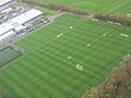
 Manchester city training ground.jpg 4,918 × 3,683; 13.5 MB
-
 Manchester from the air - geograph.org.uk - 3949537.jpg 640 × 480; 181 KB
-
 Manchester from the air - geograph.org.uk - 3949574.jpg 640 × 480; 161 KB
-
 Manchester from the air - geograph.org.uk - 3949594.jpg 640 × 480; 124 KB
-
 Manchester from the air - geograph.org.uk - 4032962.jpg 640 × 480; 132 KB
-
 Manchester from the air - geograph.org.uk - 4542751.jpg 583 × 640; 174 KB
-
 Manchester from the air - geograph.org.uk - 4542760.jpg 640 × 480; 141 KB
-
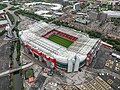 Manchester United Old Trafford.jpg 4,995 × 3,741; 15.63 MB
-
 MUFC training ground Carrington.jpg 2,592 × 1,944; 1.15 MB
-
 Nob End locks aerial view of restoration.jpg 2,696 × 1,352; 1.95 MB
-
 NOMA CGI Site Plan.jpg 3,000 × 1,688; 3.59 MB
-
 Old Trafford and Salford docks from the air (geograph 4887111).jpg 1,024 × 576; 159 KB
-
 Oldham banner aerial view from north.JPG 3,150 × 450; 582 KB
-
 Oldham from the air - geograph.org.uk - 4248160.jpg 640 × 480; 182 KB
-
 Oldham from the air - geograph.org.uk - 4248163.jpg 640 × 480; 180 KB
-
 Oldham town centre, aerial view from north.JPG 3,504 × 2,127; 1.61 MB
-
 One Angel Square during night, December 2012.jpg 2,560 × 1,669; 1.37 MB
-
 Rochdale from the air - geograph.org.uk - 4248081.jpg 640 × 480; 116 KB
-
 Sainsburys and John Lewis, A34 Cheadle..jpg 800 × 600; 105 KB
-
 StockportInterchange.jpg 1,600 × 900; 364 KB
-
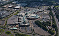 Trafford-arial.jpg 3,323 × 2,054; 5.48 MB
-
 TraffordCentresat.png 992 × 653; 1.3 MB
-
 University of Salford, aerial 2011.jpg 640 × 427; 85 KB
-
 Wardley and Hazelhurst from the air - geograph.org.uk - 3948388.jpg 640 × 480; 139 KB
-
 Wigan Locks (2300060057).jpg 2,000 × 3,008; 3.73 MB
-
 Worsley and Walkden from the air - geograph.org.uk - 4247980.jpg 640 × 410; 116 KB


.jpg)


.jpg)
.jpg)
.jpg)


.jpg)


.jpg)


.jpg)


.jpg)
