Category:Aerial photographs of Haselbachtal
Urban municipalities:
Rural municipalities:
Burkau · Crostwitz · Doberschau-Gaußig · Elsterheide · Großdubrau · Großpostwitz · Göda · Haselbachtal · Hochkirch · Kubschütz · Königswartha · Laußnitz · Lichtenberg · Lohsa · Malschwitz · Nebelschütz · Neschwitz · Ottendorf-Okrilla · Oßling · Panschwitz-Kuckau · Puschwitz · Radibor · Ralbitz-Rosenthal · Räckelwitz · Schwepnitz · Spreetal · Wachau
Former municipalities:
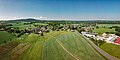
Media in category "Aerial photographs of Haselbachtal"
The following 18 files are in this category, out of 18 total.
-
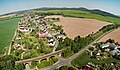
 Haselbachtal Bischheim Aerial alt.jpg 4,000 × 2,250; 6.74 MB
-
 Haselbachtal Bischheim Aerial Pan alt.jpg 10,157 × 3,610; 26.94 MB
-
 Haselbachtal Bischheim Aerial Pan alt2.jpg 5,293 × 3,087; 13.56 MB
-
 Haselbachtal Bischheim Aerial Pan.jpg 5,913 × 4,358; 17.96 MB
-
 Haselbachtal Bischheim Aerial.jpg 4,000 × 2,250; 8.26 MB
-
 Haselbachtal Gersdorf Aerial alt.jpg 3,941 × 2,140; 6.8 MB
-
 Haselbachtal Gersdorf Aerial Pan alt.jpg 9,047 × 3,645; 25.29 MB
-
 Haselbachtal Gersdorf Aerial Pan.jpg 8,918 × 3,856; 26.66 MB
-
 Haselbachtal Gersdorf Aerial.jpg 3,933 × 2,135; 6.49 MB
-
 Haselbachtal Häslich Aerial alt.jpg 4,000 × 2,250; 7.72 MB
-
 Haselbachtal Häslich Aerial Pan.jpg 7,759 × 3,753; 21.6 MB
-
 Haselbachtal Häslich Aerial.jpg 4,000 × 2,250; 7.5 MB
-
 Haselbachtal Möhrsdorf Aerial Pan.jpg 10,392 × 3,598; 29.56 MB
-
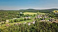
 Haselbachtal Möhrsdorf Aerial.jpg 3,925 × 2,156; 6.73 MB
-
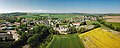
 Haselbachtal Reichenau Aerial Pan.jpg 9,476 × 3,704; 29.59 MB
-
 Haselbachtal Reichenau Aerial.jpg 4,000 × 2,250; 7.64 MB
-
 Haselbachtal Reichenbach Aerial Pan.jpg 7,435 × 3,747; 20.27 MB
-
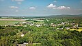
 Haselbachtal Reichenbach Aerial.jpg 4,000 × 2,250; 6.63 MB


