Category:Aerial photographs of Lake Huron
Media in category "Aerial photographs of Lake Huron"
The following 23 files are in this category, out of 23 total.
-
 180th FW flies training sortie 150625-F-FY748-287.jpg 7,360 × 4,912; 5.23 MB
-
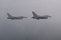 180th FW trains in Michigan 150625-F-FY748-215.jpg 4,950 × 3,300; 2.28 MB
-
 180th FW trains in Michigan 150626-F-FY748-552.jpg 5,210 × 3,477; 2.79 MB
-
 180th FW trains in Michigan 150626-F-FY748-673.jpg 5,188 × 3,462; 3.34 MB
-
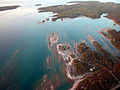
 Aerial view of Kettle Point -a.jpg 4,368 × 2,912; 10.77 MB
-
 Aerial view of Kettle Point -b.jpg 4,024 × 2,222; 8.77 MB
-
 Aerial view of Kettle Point -c.jpg 3,864 × 2,350; 8.05 MB
-
 Aerial view of Kettle Point -d.jpg 3,654 × 1,976; 7.06 MB
-
 Aerial view of Kettle Point -e.jpg 4,368 × 2,912; 11.69 MB
-
 Arthur J in Lake Huron 120720-G-AW789-051.jpg 2,784 × 1,848; 2.64 MB
-
 Arthur J in Lake Huron 120720-G-AW789-061.jpg 2,784 × 1,848; 2.75 MB
-
 Bayfield River enters Lake Huron.jpg 1,111 × 1,555; 1.66 MB
-
 Brucesky.jpg 800 × 600; 101 KB
-
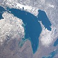
 ISS067-E-14016 Lake Michigan–Huron.jpg 5,568 × 3,712; 2.62 MB
-
 ISS067-E-7704 Islands between Manitoulin Island and the Bruce Peninsula.jpg 5,568 × 3,712; 1.97 MB
-
 ISS067-E-7705 northwestern Bruce Peninsula.jpg 5,568 × 3,712; 2.42 MB
-
 ISS067-E-7710.jpg North Channel in Lake Huron.jpg 5,568 × 3,712; 2.66 MB
-
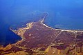 Kettle Point on Lake Huron.jpg 3,504 × 2,336; 8.47 MB
-
 Lake Huron in winter.jpg 2,400 × 2,400; 883 KB
-
 Lake Huron NASA.jpg 914 × 887; 561 KB
-
 Lakes Michigan and Huron (MODIS 2021-09-07).jpg 3,280 × 2,449; 4.8 MB
-
 Let it snow (Satellite image).jpg 10,980 × 15,613; 44.38 MB
-
 North Channel on March 20, 2022, cropped from R2AWF03202022280038, IRS AWiFS.png 4,858 × 2,486; 9.11 MB


.jpg)
.jpg)
