Category:Aerial photographs of Melbourne
- Aerial photographs of Melbourne — in Victoria, Australia.
Subcategories
This category has the following 3 subcategories, out of 3 total.
Media in category "Aerial photographs of Melbourne"
The following 200 files are in this category, out of 336 total.
(previous page) (next page)-
 A pier at Lillydale Lake.jpg 4,032 × 3,024; 3.07 MB
-
 Aerial - Sunbury.jpg 1,600 × 1,200; 618 KB
-
 Aerial of Melbourne's Central Business District (CBD).jpg 5,184 × 3,456; 8.09 MB
-
 Aerial panorama of Box Hill facing east towards the Dandenong Ranges. April 2023.jpg 8,192 × 3,310; 6.32 MB
-
 Aerial panorama of Box Hill facing west towards the Melbourne skyline.jpg 8,192 × 3,308; 5.99 MB
-
 Aerial panorama of Box Hill, taken from Surrey Park. Taken April 2018.jpg 3,378 × 2,001; 3.64 MB
-
 Aerial panorama of Burwood East reserve facing the city skyline.jpg 8,192 × 3,316; 10.31 MB
-
 Aerial panorama of Candlebark Park alongside Fitzsimmons Reserve dog offleash area.jpg 8,192 × 3,306; 6.48 MB
-
 Aerial panorama of Chadstone facing the city skyline.jpg 8,192 × 3,250; 9.93 MB
-
 Aerial panorama of Chadstone Shopping Centre and its surrounds.jpg 8,192 × 3,314; 7.19 MB
-
 Aerial panorama of Chadstone Shopping Centre with the Dandenong Ranges on the horizon.jpg 8,192 × 3,322; 7.08 MB
-
 Aerial panorama of Coldstream and the Great Dividing Range on the horizon. March 2023.jpg 8,192 × 3,312; 5.94 MB
-

-
 Aerial panorama of Currawong Bush Park facing east to the Dandenong Ranges.jpg 8,192 × 3,326; 9.9 MB
-
 Aerial panorama of Currawong Bush Park facing Melbourne city.jpg 8,192 × 3,306; 9.67 MB
-
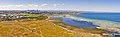
 Aerial panorama of Elsternwick Park and Port Philip Bay.jpg 8,192 × 3,318; 9.71 MB
-
 Aerial panorama of Eltham facing the Melbourne CBD. March 2023.jpg 8,192 × 3,322; 7.07 MB
-
 Aerial panorama of Heidelberg facing the Melbourne skyline. February 2024.jpg 8,192 × 3,318; 10.32 MB
-
 Aerial panorama of Heidelberg facing west towards the Dandenongs. February 2024.jpg 8,192 × 3,320; 10.15 MB
-
 Aerial panorama of Heidelberg West. April 2023.jpg 8,192 × 3,304; 6.51 MB
-
 Aerial panorama of Laverton, Victoria facing south.jpg 5,443 × 1,905; 7.9 MB
-
 Aerial panorama of Macleod facing east towards the Dandenong Ranges. February 2024.jpg 8,192 × 3,326; 8.97 MB
-
 Aerial panorama of Macleod facing west towards the Melbourne skyline. February 2024.jpg 8,192 × 3,324; 9.65 MB
-
-
 Aerial panorama of Malvern facing east to the Dandenong Ranges. April 2023.jpg 8,192 × 3,302; 8.44 MB
-

-
 Aerial panorama of Melbourne General Cemetery in Carlton. September 2023.jpg 8,192 × 3,310; 5.81 MB
-
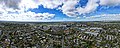
 Aerial panorama of Melbourne's skyline from Carlton North. September 2023.jpg 8,192 × 3,292; 5.92 MB
-
 Aerial panorama of Middle Brighton pier and its surrounds.jpg 8,192 × 3,320; 6.14 MB
-
 Aerial panorama of Mount Dandenong with Croydon in the foreground.jpg 8,192 × 3,314; 8.93 MB
-
 Aerial panorama of Port Melbourne.jpg 8,192 × 3,312; 7.72 MB
-
 Aerial panorama of Royal Park. The Melbourne skyline sits on the left of the horizon.jpg 8,192 × 3,310; 6.86 MB
-
 Aerial panorama of Ruffey Lake Park. Sunset 24 September 2023.jpg 8,192 × 3,308; 5.9 MB
-
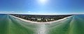 Aerial panorama of Seaford's Keast Park alongside the coastline.jpg 8,192 × 3,318; 8.56 MB
-
 Aerial panorama of Seaholme Beach.jpg 4,749 × 1,448; 5.25 MB
-
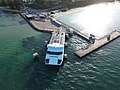
 Aerial panorama of Sorrento with the SeaRoad ferry and Sorrento Pier. March 2023.jpg 8,192 × 3,310; 5.6 MB
-
 Aerial panorama of Sorrento. March 2023.jpg 8,192 × 3,314; 6.24 MB
-
-
 Aerial panorama of the Docklands facing the Bolte Bridge.jpg 8,192 × 3,318; 8.6 MB
-
 Aerial panorama of the Docklands from Ron Barassi Sr Park.jpg 8,192 × 3,292; 8.18 MB
-
 Aerial panorama of the elevation of Doncaster Hill and its surrounds. April 2023.jpg 8,192 × 3,306; 6.25 MB
-
 Aerial panorama of the Heidelberg Olympic Village and surrounds. Shot April 2023.jpg 8,192 × 3,316; 6.53 MB
-
 Aerial panorama of the M1 freeway in Laverton.jpg 8,653 × 2,447; 14.9 MB
-
 Aerial panorama of University of Melbourne facing the city skyline. September 2023.jpg 8,192 × 3,320; 5.71 MB
-
 Aerial panorama of Wattle Tree Park facing Melbourne's skyline. August 2023.jpg 8,192 × 3,310; 6.42 MB
-
 Aerial panorama of Waverley Park facing the Melbourne city skyline. September 2023.jpg 8,192 × 3,310; 4.99 MB
-
 Aerial Panorama of Werribee Park.jpg 5,772 × 2,051; 11.13 MB
-
 Aerial panorama of Westfield Doncaster and its surrounds on Doncaster Hill. April 2023.jpg 8,192 × 3,310; 6.31 MB
-
 Aerial panorama of Williams Landing.jpg 9,377 × 2,710; 15.61 MB
-
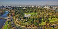
 Aerial perspective of Albert Park Lake.jpg 3,819 × 1,693; 4.41 MB
-
 Aerial perspective of Aqualink Box Hill.jpg 4,000 × 3,000; 5.9 MB
-

-
 Aerial perspective of Black Rock, facing south along Port Philip Bay. Jan 2019.jpg 3,857 × 2,170; 4.4 MB
-
 Aerial perspective of Burwood East reserve facing west to the city skyline.jpg 4,032 × 3,024; 5.08 MB
-
 Aerial perspective of Eagle Stadium, Werribee.jpg 2,213 × 1,221; 2.72 MB
-
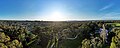
 Aerial perspective of Eltham facing the Great Dividing Range. March 2023.jpg 8,192 × 3,318; 6.49 MB
-
 Aerial perspective of Ferntree Gully Quarry Recreational Reserve.jpg 4,000 × 2,250; 4.91 MB
-

-
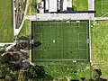 Aerial perspective of Heidelberg United Football Club. April 2023.jpg 4,032 × 3,024; 4.28 MB
-

-
 Aerial perspective of Odyssey House along the Yarra Main Trail.jpg 3,167 × 1,779; 4.09 MB
-
 Aerial perspective of Pacific Werribee Shopping Centre. Taken April 2017.jpg 1,000 × 750; 849 KB
-
 Aerial perspective of Penrose Promenade Community Centre. Shot 4th quarter 2018.jpg 4,000 × 3,000; 5.04 MB
-
 Aerial perspective of Plenty War Memorial Park. December 2022.jpg 8,192 × 3,312; 9.62 MB
-
 Aerial perspective of South Melbourne Market, Feb 2019.jpg 2,138 × 1,208; 1.24 MB
-
 Aerial perspective of St Hubert Vineyard and the Hubert Estate. March 2023.jpg 4,032 × 3,024; 3.23 MB
-
 Aerial perspective of St John The Apostle School.jpg 4,000 × 2,250; 4.47 MB
-
 Aerial perspective of St Joseph's College in Ferntree Gully.jpg 4,000 × 2,250; 4.18 MB
-
 Aerial perspective of Surrey Park Model Boat Club.jpg 4,000 × 3,000; 6.7 MB
-
 Aerial perspective of Tarneit Central Cricket Club. Shot in 4th quarter 2018.jpg 4,000 × 3,000; 5.77 MB
-

-
 Aerial perspective of the Diamond Valley Railway. March 2023.jpg 4,032 × 3,024; 3.68 MB
-
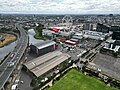
 Aerial perspective of the former Standard Brickworks at Federation Street Box Hill.jpg 4,000 × 3,000; 6.52 MB
-
 Aerial perspective of the lake at Elsternwick Park.jpg 4,032 × 3,024; 4.8 MB
-
 Aerial perspective of the Melbourne Star Observation Wheel.jpg 5,027 × 2,824; 9.23 MB
-
 Aerial perspective of the Melbourne Star, the District and Docklands film studio.jpg 4,032 × 3,024; 4.69 MB
-
 Aerial perspective of the Mobil refinery and its surrounds in Altona. 2018.jpg 4,000 × 2,250; 4.15 MB
-
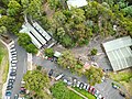 Aerial perspective of the parking lots at Diamond Valley Miniature Railway. March 2023.jpg 4,032 × 3,024; 3.99 MB
-
 Aerial perspective of the parkland at Ferntree Gully Quarry Recreational Reserve.jpg 4,000 × 2,250; 4.6 MB
-
 Aerial perspective of the quarry lake at Ferntree Gully Quarry Recreational Reserve.jpg 4,000 × 2,250; 4.31 MB
-

-
-
 Aerial perspective of the Sidney Myer Bowl.jpg 5,338 × 2,688; 6.95 MB
-
 Aerial perspective of the Star-shaped garden bed in Alexandra Gardens.jpg 4,000 × 3,000; 7.3 MB
-
 Aerial perspective of Thomas Chirnside School.jpg 2,710 × 2,179; 4.49 MB
-
 Aerial perspective of Waverley Park facing east towards Mount Dandenong. September 2023.jpg 8,192 × 3,312; 5.66 MB
-

-
 Aerial perspective of Yalukit Willam Nature Reserve.jpg 4,032 × 3,024; 5.42 MB
-
 Aerial photo of Mobil Terminal Altona (51106790446).jpg 4,000 × 2,250; 2.5 MB
-
 Aerial Photo of Royal Exhibition Building, Melbourne.jpg 640 × 426; 393 KB
-
 Aerial photograph of Melbourne in 1956.jpg 1,000 × 750; 771 KB
-
 Aerial photograph of Queen Victoria Market.jpg 3,012 × 1,434; 4.42 MB
-

-

-
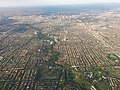
 Aerial view of Melbourne from the west.jpg 3,839 × 2,879; 1.72 MB
-
 Aerial view of Melbourne in 1956. Image crop.png 990 × 381; 770 KB
-
 Aerial vista of Malvern Town Hall. April 2023.jpg 4,032 × 2,268; 4.25 MB
-
 Aerial vista of the Malvern Cricket Ground. April 2023.jpg 4,032 × 2,268; 4.21 MB
-
 Aerial vista of the Melbourne CBD from Altona Coastal Park.jpg 4,000 × 2,250; 3.58 MB
-
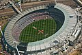 AFL Grand Final 2010 on the Melbourne Cricket Ground.jpg 1,600 × 1,071; 1.77 MB
-
 Altona foreshore from the air (51106689243).jpg 8,000 × 6,000; 10.85 MB
-
 Altona from the air looking east (51106218932).jpg 4,000 × 2,250; 2.63 MB
-
 Altona Meadows from AB Shaw Reserve (51107570730).jpg 4,000 × 2,250; 2.42 MB
-
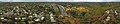
 Attwood VIC 2017.jpg 3,168 × 2,112; 5.3 MB
-
 Aura Vale Lake Aerial Panorama.jpg 16,984 × 5,064; 37.76 MB
-
 Autumn Sunrise over Box Hill.jpg 4,032 × 3,024; 2.09 MB
-
 Bay Trail at Altona Dog Beach (51106535109).jpg 4,000 × 2,250; 1.92 MB
-
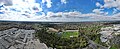
 Belgrave South aerial 1.jpg 2,288 × 1,712; 3.27 MB
-
 Bell Street Bridge over Darebin Creek, Bellfield (52293783673).jpg 4,000 × 2,250; 3.11 MB
-
 Bellbridge Primary School.jpg 6,691 × 3,162; 12.77 MB
-
 Boat houses along Kororoit Creek, Williamstown North (51107567475).jpg 4,000 × 2,250; 3.05 MB
-
 Box Hill Aerial Panorama. Taken from Surrey Park. April 2018.jpg 6,343 × 3,940; 11.86 MB
-
 Box Hill from above. From Surrey Park.jpg 8,192 × 3,274; 13.51 MB
-
 Box Hill's Surrey Park Sporting Grounds.jpg 8,192 × 3,276; 12.28 MB
-
 Box Hill, VIC banner.jpg 4,000 × 571; 1.23 MB
-
 Bundoora aerial panorama facing the Great Dividing Range. March 2024.jpg 8,192 × 3,284; 5.52 MB
-
 Bundoora aerial panorama facing the Melbourne skyline. March 2024.jpg 8,192 × 3,328; 5.42 MB
-
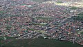
 Bundoora VIC 2017.jpg 2,581 × 1,666; 3.02 MB
-
 Burwood East aerial panorama facing the city.jpg 8,192 × 3,322; 9.93 MB
-
 Burwood East facing the Dandenong Ranges to the East.jpg 8,192 × 3,282; 9.81 MB
-
 C H Sullivan Memorial Park, Reservoir (52585463952).jpg 4,000 × 2,250; 5.01 MB
-
 Capel Sound aerial panorama. April 2024.jpg 8,192 × 3,332; 8.68 MB
-
 Capel Sound from above during sunrise. April 2024.jpg 8,192 × 3,286; 7.3 MB
-
 Caroline Springs Vic aerial2.jpg 2,288 × 1,712; 2.3 MB
-
 Central Melbourne, 13 Aug. 2010 - Flickr - PhillipC (1).jpg 4,288 × 2,848; 4.57 MB
-
 Central Melbourne, 13 Aug. 2010 - Flickr - PhillipC.jpg 4,288 × 2,848; 4.15 MB
-
 Chadstone Shopping Centre aerial perspective facing south.jpg 4,032 × 2,268; 3.07 MB
-

-
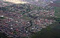
 Coburg North VIC 3058, Australia - panoramio.jpg 3,264 × 2,448; 2.71 MB
-
 Coolaroo Meadow Heights aerial.jpg 2,288 × 1,712; 845 KB
-
 Craigieburn 1 aerial.jpg 2,265 × 599; 1.39 MB
-
 Croydon Light Harness Club and Mount Dandenong on the horizon.jpg 8,192 × 3,320; 8.75 MB
-
 Croydon Light Harness Club from above.jpg 4,032 × 2,268; 3.4 MB
-
 Darebin Creek at Thornbury looking south.jpg 4,000 × 2,250; 6.53 MB
-
 Darebin Creek near Donaldson Creek, Northcote.jpg 4,032 × 3,024; 4.99 MB
-
 Darebin Creek parklands, Thornbury.jpg 4,000 × 2,250; 4.81 MB
-

-
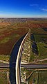 Davis Road flyover - panoramio.jpg 3,444 × 6,075; 13.09 MB
-
 Deakin University Aerial Panorama.jpg 9,721 × 2,572; 13.62 MB
-
 Deakin University Burwood Campus Aerial Panorama.jpg 9,721 × 2,572; 11.42 MB
-
-
 Edwardes Lake panorama facing the Melbourne skyline. March 2024.jpg 8,192 × 3,308; 9.6 MB
-

-
 Eltham aerial.jpg 2,288 × 1,712; 2.84 MB
-
 Epping Plaza.jpg 1,389 × 461; 556 KB
-
 Flinders Street Station overhead view.jpg 1,370 × 1,712; 672 KB
-
 Flying over Melbourne 2.jpg 2,048 × 1,152; 398 KB
-
 Flying over Melbourne.jpg 2,048 × 1,152; 337 KB
-
 Former junction of Outer Circle Line and Hurstbridge Line at Fulham Grange, Alphington.jpg 4,000 × 2,250; 3.47 MB
-
 Former public housing site on Bardia Avenue in West Heidelberg (52293783998).jpg 4,000 × 2,250; 3.68 MB
-
 Frankston coastline facing north towards Melbourne.jpg 8,192 × 3,298; 8.23 MB
-
 Good evening Tarneit - panoramio.jpg 6,000 × 1,624; 7.05 MB
-
 Greensborough Plaza aerial.jpg 1,237 × 1,007; 982 KB
-
 Greensborough-overall-aerial.jpg 1,024 × 664; 158 KB
-
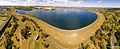 Greenvalereservoir-feb2017-200dpi.jpg 5,512 × 2,259; 10.85 MB
-
 Hillcrest Reserve and the Eastlink Melba Tunnel.jpg 18,888 × 3,778; 58.06 MB
-
 Hillside Vic aerial.jpg 2,285 × 1,295; 2.12 MB
-
 Hillside West aerial.jpg 754 × 470; 311 KB
-

-
 Intersection of Grange Road, Heidelberg Road and Chandler Highway, Alphington.jpg 4,000 × 2,250; 3.57 MB
-
 ISS-60 Melbourne, Australia on Port Philip Bay.jpg 5,568 × 3,712; 2.59 MB
-
 Late afternoon shadows on approach to Tullamarine (16368251603).jpg 2,592 × 1,936; 495 KB
-
 Leaving Melbourne (5147226939).jpg 1,600 × 1,067; 1.49 MB
-
 Lillydale Lake aerial panorama. Shot February 2023.jpg 8,192 × 3,318; 6.36 MB
-
 Lillydale Lake's parkland and playgrounds from above.jpg 8,192 × 3,318; 6.83 MB
-
 Looking along Darebin Creek, Thornbury.jpg 4,000 × 2,250; 5.93 MB
-

-
-
 Looking north along Darebin Creek from Bell Street, West Heidelberg (52294267305).jpg 4,000 × 2,250; 2.56 MB
-
 Looking south across West Heidelberg from Darebin Creek Forest Park (52585937336).jpg 4,000 × 2,250; 5.46 MB
-
 Looking west along Bell Street from Darebin Creek, West Heidelberg (52294267265).jpg 3,956 × 2,225; 2.4 MB
-
 Marvel Stadium from an aerial perspective. Feb 2019.jpg 4,000 × 2,250; 4.02 MB
-
 Melb aerial 2020 - Fishermans Bend to city.jpg 2,645 × 1,965; 1.71 MB
-
 Melb aerial 2020 - Flemington Kensington to city.jpg 2,880 × 2,160; 1.99 MB
-
 Melb aerial 2020 - Keilor Park looking E.jpg 2,880 × 2,160; 1.91 MB
-
 Melb aerial 2020 - Williamstown.jpg 2,880 × 2,160; 1.95 MB
-
 Melb aerial 2020 - Yarraville and port.jpg 2,880 × 2,160; 2.14 MB
-
 Melbourne 1.jpg 1,292 × 500; 392 KB
-
 Melbourne aerial from balloon-01 2007-03-05.jpg 2,560 × 1,712; 1.42 MB
-
 Melbourne aerial from balloon-02 2007-03-05.jpg 2,560 × 1,712; 1.41 MB
-
 Melbourne aerial from balloon-03 2007-03-05.jpg 2,560 × 1,712; 1.48 MB
-
 Melbourne aerial from balloon-04 2007-03-05.jpg 2,560 × 1,712; 704 KB
-
 Melbourne aerial from balloon-05 2007-03-05.jpg 2,560 × 1,712; 1.53 MB
-
 Melbourne aerial from balloon-06 2007-03-05.jpg 2,560 × 1,712; 1.52 MB
-
 Melbourne aerial from balloon-07 2007-03-05.jpg 2,560 × 1,712; 1.36 MB
-
 Melbourne aerial from balloon-08 2007-03-05.jpg 2,560 × 1,712; 1.51 MB
-
 Melbourne aerial from balloon-09 2007-03-05.jpg 2,560 × 1,712; 1.5 MB
-
 Melbourne aerial from balloon-10 2007-03-05.jpg 2,560 × 1,712; 1.45 MB
-
 Melbourne aerial from balloon-11 2007-03-05.jpg 2,560 × 1,712; 1.45 MB
-
 Melbourne aerial from balloon-12 2007-03-05.jpg 2,560 × 1,712; 1.32 MB
-
 Melbourne aerial from balloon-13 2007-03-05.jpg 2,560 × 1,712; 1.33 MB
-
 Melbourne aerial from balloon-14 2007-03-05.jpg 2,560 × 1,712; 1.38 MB
-
 Melbourne aerial photograph c 1945-1954.jpg 1,000 × 730; 190 KB
-
 Melbourne aérea.jpg 2,724 × 1,812; 4.68 MB
-
 Melbourne CBD aerial from balloon-01 2007-03-05.jpg 2,560 × 1,712; 1.43 MB
-
 Melbourne CBD aerial from balloon-02 2007-03-05.jpg 2,560 × 1,712; 1.46 MB
-
 Melbourne CBD aerial from balloon-03 2007-03-05.jpg 2,560 × 1,712; 1.56 MB
-
 Melbourne CBD aerial from balloon-04 2007-03-05.jpg 2,560 × 1,712; 1.44 MB
-
 Melbourne CBD aerial from balloon-05 2007-03-05.jpg 2,560 × 1,712; 1.57 MB
-
 Melbourne CBD aerial from balloon-06 2007-03-05.jpg 2,560 × 1,712; 1.55 MB


.jpg)


.jpg)


.jpg)


.jpg)
.jpg)
.jpg)


.jpg)

.jpg)

.jpg)


.jpg)

.jpg)


.jpg)


.jpg)


.jpg)


.jpg)
.jpg)

.jpg)
.jpg)
.jpg)
.jpg)
.jpg)


