Category:Aerial photographs of Nagano prefecture

Subcategories
This category has only the following subcategory.
Media in category "Aerial photographs of Nagano prefecture"
The following 57 files are in this category, out of 57 total.
-
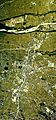
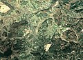
 20150113中央構造線.JPG 3,840 × 2,160; 4.31 MB
-
 20150202日本アルプス雪化粧.jpg 2,592 × 1,458; 2.78 MB
-
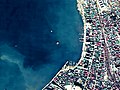 Aerial photograph of an artificial island built in the Lake Suwa.jpg 2,022 × 1,516; 3.35 MB
-
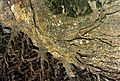
 Aerial photograph of Jusan cliff on the right bank of Yomase River. November 4, 1976.jpg 2,354 × 1,766; 1.79 MB
-
 CB20018Y-C6-13 Lake Senroku, Saku Interchange 2001.jpg 567 × 424; 109 KB
-
 Chino city center area Aerial photograph.1976.jpg 4,733 × 3,196; 13.96 MB
-
 Daiasama Golf Club, Miyota Nagano Aerial photograph.2005.jpg 1,669 × 1,252; 1,018 KB
-
 Enrei Country Club, Shiojiri Nagano Aerial photograph.2011.jpg 3,742 × 4,989; 6.86 MB
-
 Hijiri Museum aerial photograph.jpg 300 × 300; 30 KB
-
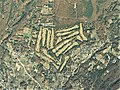
 Hotaka Country Club, Azumino Nagano Aerial photograph.1977.jpg 2,157 × 1,618; 1.13 MB
-
 Iida city center area Aerial photograph.1976.jpg 5,477 × 5,122; 20.94 MB
-
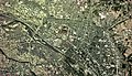
 IidaCity.jpg 2,816 × 2,112; 1.72 MB
-
 Iiyama city center area Aerial photograph.1976.jpg 5,636 × 3,479; 16.06 MB
-
 Ina city center area Aerial photograph.1976.jpg 4,605 × 3,380; 14.31 MB
-
 Inakura-tabada-1975-CCB7513-C21-37 -B.jpg 2,618 × 2,162; 12.4 MB
-
 Karuizawa 72 Golf, Karuizawa Nagano Aerial photograph.2015.jpg 7,011 × 5,258; 9.63 MB
-
 Karuizawa Golf Club, Karuizawa Nagano Aerial photograph.2015.jpg 3,734 × 2,801; 2.92 MB
-
 Komagane city center area Aerial photograph.1976.jpg 2,849 × 6,088; 14.23 MB
-
 Komoro city center area Aerial photograph.1975.jpg 5,464 × 5,861; 22.13 MB
-
 Kyu-Karuizawa Golf Club, Karuizawa Nagano Aerial photograph.2015.jpg 1,989 × 1,492; 1.01 MB
-
 Lake Aoki and Lake Nakatsuna Aerial photograph.1977.jpg 3,751 × 5,723; 17.71 MB
-
 Lake Kizaki Aerial photograph.1977.jpg 2,823 × 6,384; 12.66 MB
-
 Lake Shirakaba Aerial photograph.1976.jpg 2,519 × 1,823; 4.26 MB
-
 Matsumoto city center area Aerial photograph.1975.jpg 4,565 × 4,917; 22.77 MB
-
 Mishakaike water reservoir Aerial photograph.1976.jpg 1,069 × 780; 801 KB
-
 Miwako.jpg 800 × 650; 204 KB
-
 Nagano airport aerial photograph.jpg 1,171 × 878; 1.08 MB
-
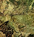
 Nagano city center area Aerial photograph.1975.jpg 8,534 × 6,720; 49.34 MB
-
 Nagano Country Club, Nagano Aerial photograph.1976.jpg 1,790 × 1,343; 952 KB
-
 Nakano city center area Aerial photograph.1976.jpg 4,407 × 3,374; 12.4 MB
-
 NorthSakudaira.jpg 2,816 × 2,112; 713 KB
-
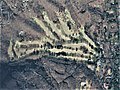
 Obasute-tanada-2010-CCB20105-C32-6.jpg 3,552 × 3,256; 18.26 MB
-
 Okaya city center area Aerial photograph.1975.jpg 5,013 × 4,939; 21.51 MB
-
 Omachi city center area Aerial photograph.1977.jpg 5,142 × 7,158; 29.14 MB
-
 Omi elementary school, CCB7513-C17-9.jpg 295 × 228; 26 KB
-
 Saku city center area Aerial photograph.1975.jpg 5,210 × 7,676; 28.24 MB
-
 Sakudaira.jpg 1,025 × 774; 194 KB
-
 Seninzuka Jogaike water reservoir Aerial photograph.1976.jpg 2,466 × 1,778; 3.49 MB
-
 Shiojiri city center area Aerial photograph.1975.jpg 4,675 × 3,224; 11.6 MB
-
 ShiroumaBonchi.jpg 1,280 × 960; 201 KB
-
 Sugadaira Kogen Sports Land.jpg 1,866 × 1,006; 855 KB
-
 Sugeodaira Warm water reservoir Aerial photograph.1977.jpg 1,889 × 1,370; 2.58 MB
-
 Suwa city center area Aerial photograph.1975.jpg 4,505 × 5,448; 16 MB
-
 Suwako Country Club, Suwa Nagano Aerial photograph.1975.jpg 2,494 × 1,871; 1.58 MB
-
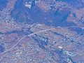
 Suwako2.jpg 834 × 600; 144 KB
-
 Suzaka city center area Aerial photograph.1975.jpg 5,550 × 4,956; 21.75 MB
-
 Takamori-machi junior high school Aerial Shoot.jpg 4,056 × 3,040; 6.86 MB
-
 Takamori-machi Kouminkan public-hall Aerial Shoot.jpg 4,056 × 3,040; 6.44 MB
-
 TakaseGawa.jpg 1,280 × 960; 290 KB
-
 Tankakyo District Aerial photograph.1976.jpg 3,272 × 2,367; 7.18 MB
-
 Tatsunoumi water reservoir Aerial photograph.1976.jpg 1,619 × 1,173; 1.73 MB
-
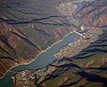
 Tenryu-kyo canyons Aerial photograph.1976.jpg 3,623 × 6,483; 21.89 MB
-
 Ueda city center area Aerial photograph.1975.jpg 6,088 × 3,506; 20.58 MB
-
 Ueda-Roman Bridge.jpg 2,560 × 1,920; 1.07 MB
-
 Unno-Juku post town district Aerial photograph.1975.jpg 2,460 × 1,774; 3.63 MB
-
 USA-R1230-32 Lake Senroku site 1948.jpg 625 × 625; 116 KB
-
 USA-R319RSV-32 Lake Senroku under construction 1955.jpg 825 × 824; 157 KB


