Category:Aerial photographs of Rhein-Hunsrück-Kreis
Urban districts (cities): Coblenz · Ludwigshafen · Mainz · Neustadt an der Weinstrasse · Speyer · Trier ·
Deutsch: Luftaufnahmen aus dem Rhein-Hunsrück-Kreis, Rheinland-Pfalz
Subcategories
This category has the following 3 subcategories, out of 3 total.
Media in category "Aerial photographs of Rhein-Hunsrück-Kreis"
The following 31 files are in this category, out of 31 total.
-
 Aerial image of the Bell-Hundheim airfield.jpg 4,500 × 3,200; 5.96 MB
-
 Aerial image of the Frankfurt-Hahn airport.jpg 5,000 × 2,800; 4.81 MB
-
 Aerial image of the Nannhausen airfield.jpg 4,600 × 3,400; 6.67 MB
-
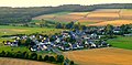
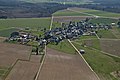
 Altweidelbach - panoramio.jpg 4,320 × 3,240; 2.59 MB
-
 Belg Hunsrueck DSC 9020.jpg 4,288 × 2,848; 4.74 MB
-
 Benzweiler - panoramio.jpg 4,000 × 3,000; 4.22 MB
-
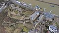 Burg Rheinfels Luftbild 01.jpg 1,712 × 970; 847 KB
-
 Burg Rheinfels Luftbild 02.jpg 1,618 × 1,647; 1.62 MB
-
 Burg Rheinfels Luftbild 090.jpg 3,008 × 2,000; 4.05 MB
-
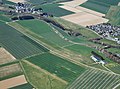
 Germany - Kümbdchen - panoramio.jpg 4,320 × 3,240; 3.72 MB
-
 Hasselbach - panoramio.jpg 4,320 × 2,132; 2.76 MB
-
 Keidelheim - Mühlenweg - panoramio.jpg 4,320 × 3,240; 2.39 MB
-
 Keidelheim - panoramio (1).jpg 4,320 × 3,240; 2.71 MB
-
 Keidelheim - panoramio.jpg 3,610 × 1,641; 1.33 MB
-
 Kirche Bell.jpg 375 × 313; 35 KB
-
 Kisselbach - panoramio.jpg 4,000 × 3,000; 4.06 MB
-
 Kümbdchen - panoramio.jpg 4,320 × 3,240; 3.21 MB
-
 Kümbdchen von Norden - panoramio.jpg 3,731 × 2,656; 2.63 MB
-
 Kümbdchen – Sportplatz und Friedhof - panoramio.jpg 3,994 × 3,229; 2.75 MB
-
 Liebshausen - panoramio (1).jpg 4,320 × 3,240; 4.79 MB
-
 Liebshausen - panoramio.jpg 4,000 × 3,000; 5.27 MB
-
 Mutterschied - panoramio.jpg 4,320 × 3,240; 3.37 MB
-
 Mutterschied vor Altweidelbach - panoramio.jpg 4,320 × 3,240; 2.92 MB
-
 Niederkumbd - panoramio.jpg 4,320 × 3,240; 2.9 MB
-
 Rayerschied - panoramio.jpg 4,000 × 3,000; 4.51 MB
-
 Rayerschied - Windräder - Kisselbach - panoramio.jpg 4,320 × 3,240; 5.95 MB
-
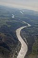 Rhein Boppard Bacharach DSC 8964.jpg 2,848 × 4,288; 3.73 MB
-
 Rhein-Lahn-Kreis - The River Rhine - geo.hlipp.de - 27529.jpg 640 × 480; 56 KB
-
 Schönburg Luftbild 091.jpg 3,008 × 2,000; 4.75 MB
-
 Steinbach - panoramio.jpg 2,737 × 1,858; 2.29 MB
-
 Wuerrich Hunsrueck DSC 9021.jpg 4,288 × 2,848; 4.12 MB


.jpg)


.jpg)


