Category:Aerial photographs of Sawbridgeshire
Media in category "Aerial photographs of Sawbridgeshire"
The following 18 files are in this category, out of 18 total.
-
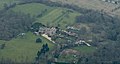
 Kecksys Farm from the air - geograph.org.uk - 4884252.jpg 640 × 446; 129 KB
-
 Pishiobury Drive - geograph.org.uk - 5682301.jpg 3,264 × 2,448; 4.36 MB
-
 Redricks Lane from the air - geograph.org.uk - 4882962.jpg 640 × 480; 149 KB
-
 Rivers Hospital from the air - geograph.org.uk - 2541580.jpg 480 × 640; 184 KB
-
 Rivers Hospital from the air - geograph.org.uk - 4884208.jpg 640 × 480; 142 KB
-
 Rivers Hospital from the air - geograph.org.uk - 4884211.jpg 640 × 480; 151 KB
-
 Rowneybury House from the air (geograph 4882967).jpg 402 × 216; 45 KB
-
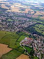
 Sawbridgeworth from the air - geograph.org.uk - 2541589.jpg 640 × 480; 202 KB
-
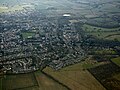
 Sawbridgeworth from the air - geograph.org.uk - 2541596.jpg 640 × 480; 195 KB
-
 Sawbridgeworth from the air - geograph.org.uk - 4884222.jpg 640 × 480; 159 KB
-
 Sawbridgeworth from the air - geograph.org.uk - 4884228.jpg 640 × 480; 176 KB
-
 Sawbridgeworth from the air - geograph.org.uk - 4884235.jpg 640 × 402; 168 KB
-
 Sawbridgeworth from the air - geograph.org.uk - 4884249.jpg 640 × 480; 152 KB
-
 Sawbridgeworth from the air - geograph.org.uk - 5462133.jpg 3,264 × 2,448; 3.62 MB
-
 Small unnamed ponds at Trims Green - geograph.org.uk - 5833330.jpg 3,264 × 2,448; 3.89 MB
-
 Tednambury Farm from the air - geograph.org.uk - 4884256.jpg 640 × 423; 112 KB
-
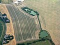
 Temple Fields from the air - geograph.org.uk - 4882947.jpg 640 × 480; 151 KB
-
 The outskirts of Sawbridgeworth - geograph.org.uk - 5682314.jpg 3,264 × 2,448; 4.16 MB


.jpg)


