Category:Aerial photographs of Ventura County, California
Counties of California: Alameda · Contra Costa · Inyo · Los Angeles · Madera · Marin · Merced · Mono · Napa · Orange · Riverside · San Bernardino · San Diego · San Mateo · Santa Barbara · Santa Clara · Shasta · Siskiyou · Sonoma · Stanislaus · Ventura · Yolo · – Consolidated city-county: San Francisco
Media in category "Aerial photographs of Ventura County, California"
The following 67 files are in this category, out of 67 total.
-
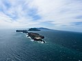
 Aerial - Santa Cruz, Santa Rosa, and San Miguel Islands (California) 01.jpg 4,288 × 2,848; 5.13 MB
-
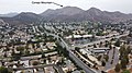
 Aerial view of Camarillo, California.jpg 4,608 × 3,456; 5.73 MB
-
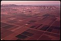
 Aerial view of farms in Oxnard, California with plastic-covered fields.jpg 4,608 × 3,456; 5.83 MB
-
 Aerial view of farms in Oxnard, California.jpg 4,608 × 3,456; 6.39 MB
-
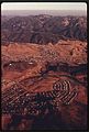
 Aerial view of Ojai, California in July 2021.jpg 3,456 × 4,608; 6.24 MB
-
-
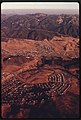
 Aerial view of Santa Paula, California in July 2021.jpg 3,456 × 4,608; 5.91 MB
-
 Aerial-AnacapaLight.jpg 800 × 591; 72 KB
-
-
-

-
 Anacapa Aerial NOAA.jpg 2,111 × 1,500; 2.61 MB
-
 Anacapa Island aerial view.jpg 600 × 750; 287 KB
-
 Anacapa-Island-Aerial.jpg 1,515 × 1,215; 1.28 MB
-
 April 2004 aerial shot of Reagan Library.jpg 350 × 280; 56 KB
-
 Between Ojai and Santa Paula, California (21556823216).jpg 4,000 × 3,000; 3.49 MB
-
 Between Ojai and Santa Paula, California (21591859581).jpg 3,930 × 3,000; 2.38 MB
-
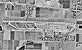 Camarillo Airport CA 3 Sep 1994.jpg 974 × 594; 149 KB
-
 Camarillo Airport-2006-USGS.jpg 768 × 768; 174 KB
-
 Channel Islands National Park in California - Aerial view (cropped).jpg 814 × 715; 231 KB
-
 Channel Islands National Park in California - Aerial view.jpg 1,024 × 761; 309 KB
-
 Conejo Mountain in Thousand Oaks.jpg 4,000 × 2,250; 2.93 MB
-
 Fillmore and Santa Clara River.jpg 1,262 × 1,985; 1.14 MB
-
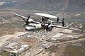 Grumman E-2C Hawkeye in flight DN-SD-04-13416.jpg 2,000 × 1,312; 823 KB
-
 Laguna Peak equipment.JPG 750 × 600; 615 KB
-
 Naval Base Ventura County Port Hueneme aerial view c1962.jpg 940 × 652; 524 KB
-
 NBVC Point Mugu aerial view.jpg 750 × 600; 513 KB
-
 NBVC Point Mugu at dawn.jpg 1,105 × 884; 268 KB
-
 Newbury Park area in Thousand Oaks, California.jpg 4,608 × 3,456; 4.51 MB
-
 NewburyPark.jpg 4,032 × 3,024; 1.69 MB
-
 Oaks Mall and surrounding area near Highway 101 and 23 in Thousand Oaks, California.jpg 4,608 × 3,456; 7.06 MB
-
 Ojai, California (20960249094) (cropped).jpg 3,523 × 1,870; 2.15 MB
-
 Ojai, California (20960249094).jpg 4,000 × 3,000; 2.97 MB
-
 Ojai, California (20961845073).jpg 4,000 × 3,000; 2.91 MB
-
 Ojai, California (20961863393).jpg 4,000 × 3,000; 3.11 MB
-
 Ojai, California (21395133368).jpg 4,000 × 3,000; 2.98 MB
-
 Ojai, California (21583025735).jpg 4,000 × 2,916; 2.74 MB
-
 Ojai, California and California Coast (21398791260).jpg 4,000 × 3,000; 2.43 MB
-
 Oxnard, Ventura, Santa Paula, and Camarillo, Oxnard Plain, California.jpg 4,000 × 3,000; 3.59 MB
-
 Santa-Clara-River-Valley-with-Piru-Aerial-from-west-August-2014 (cropped).jpg 1,824 × 2,767; 2.63 MB
-
 Santa-Clara-River-Valley-with-Piru-Aerial-from-west-August-2014.jpg 1,840 × 3,264; 3.05 MB
-
 Pt. Mugu duck ponds Dec 68 (28980075996).jpg 1,592 × 1,050; 122 KB
-
 RRPresidential2021.jpg 3,632 × 2,210; 6.85 MB
-
 San Nicolas Island (27048963529).jpg 4,032 × 3,024; 1.77 MB
-
 San Nicolas Island aerial view.jpg 750 × 600; 338 KB
-
 Santa Paula and Oxnard, California (21399010458).jpg 4,000 × 3,000; 3.85 MB
-
 Santa Paula and Oxnard, California (21560651186).jpg 4,000 × 3,000; 3.94 MB
-
 Santa Paula, California (21398796090).jpg 4,000 × 3,000; 3.7 MB
-
 Santa Paula, California (21399016118).jpg 4,000 × 3,000; 4.18 MB
-
 Santa Paula, California (21575533472).jpg 4,000 × 3,000; 3.62 MB
-
 Santa Paula, California (21595689061).jpg 4,000 × 3,000; 3.75 MB
-
 SantaPaula-Ventura-OxnardCA-Aerial (35948279465).jpg 1,600 × 2,400; 2.3 MB
-
 Sespe Wilderness, Ventura County (3600195491).jpg 3,264 × 2,448; 2.8 MB
-
 Sespe Wilderness, Ventura County (3600195977).jpg 3,264 × 2,448; 3.26 MB
-
 Sespe Wilderness, Ventura County (3600196429).jpg 3,264 × 2,448; 3.09 MB
-
 Sespe Wilderness, Ventura County (3600198921).jpg 3,264 × 2,448; 3.02 MB
-
 Sespe Wilderness, Ventura County (3601007790).jpg 3,264 × 2,448; 3.35 MB
-
 Sespe Wilderness, Ventura County (3601008306).jpg 3,264 × 2,448; 3.25 MB
-
 Sespe Wilderness, Ventura County (3601008786).jpg 3,264 × 2,448; 3.19 MB
-
 Sespe Wilderness, Ventura County (3601009274).jpg 3,264 × 2,448; 3.18 MB
-
 SherwoodAerial.jpg 4,032 × 3,024; 1.99 MB
-
 SouthMountain-nearSantaPaulaCA (35948280745).jpg 1,600 × 2,400; 2.76 MB
-
 Thomas Aquinas College, Santa Paula, California (21396131349).jpg 4,000 × 3,000; 3.41 MB
-
 Thousand Oaks, Lake Sherwood and Las Virgenes reservoir.jpg 4,608 × 3,456; 6.46 MB
-
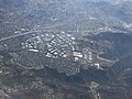
 ThousandOaksAerial.jpg 4,032 × 3,024; 1.85 MB
-
 Ventura Regional Sanitation Garbage Dump, Santa Paula, California (20965721153).jpg 4,000 × 3,000; 3.54 MB
-
 Westlake Lake in Thousand Oaks, California.jpg 4,604 × 3,180; 7.1 MB
_01.jpg)


.jpg)
.jpg)


.jpg)


_(cropped).jpg)
.jpg)
.jpg)
.jpg)
.jpg)
.jpg)
.jpg)

.jpg)

.jpg)

.jpg)

.jpg)
.jpg)
.jpg)
.jpg)
.jpg)
.jpg)
.jpg)
.jpg)
.jpg)
.jpg)
.jpg)
.jpg)
.jpg)
.jpg)
.jpg)

.jpg)
.jpg)


.jpg)
