Category:Aerial photographs of Vijfheerenlanden
Nederlands: Afbeeldingen van luchtfoto's van de gemeente Vijfheerenlanden in de provincie Utrecht in het midden van Nederland
Subcategories
This category has the following 2 subcategories, out of 2 total.
*
Media in category "Aerial photographs of Vijfheerenlanden"
The following 10 files are in this category, out of 10 total.
-
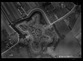
 NIMH - 2011 - 0919 - Aerial photograph of Everdingen, The Netherlands - 1920 - 1940.jpg 3,500 × 2,571; 1.59 MB
-
 NIMH - 2011 - 0920 - Aerial photograph of Everdingen, The Netherlands - 1920 - 1940.jpg 3,500 × 2,544; 1.47 MB
-
 NIMH - 2011 - 0921 - Aerial photograph of Everdingen, The Netherlands - 1920 - 1940.jpg 3,500 × 2,552; 1.77 MB
-
 NIMH - 2011 - 0922 - Aerial photograph of Everdingen, The Netherlands - 1920 - 1940.jpg 3,500 × 2,549; 1.35 MB
-
 NIMH - 2011 - 5282 - Aerial photograph of Vianen, The Netherlands.jpg 4,000 × 2,793; 2.2 MB
-
 NIMH - 2011 - 5283 - Aerial photograph of Vianen, The Netherlands.jpg 4,000 × 2,716; 1.58 MB
-
 NIMH - 2011 - 9059 - Aerial photograph of Vianen, The Netherlands.jpg 4,000 × 2,900; 2.26 MB
-
 NIMH - 2011 - 9060 - Aerial photograph of Vianen, The Netherlands.jpg 4,000 × 2,717; 2.98 MB
-
 Zij- en voorgevel - Vianen - 20450757 - RCE.jpg 1,200 × 900; 249 KB
-
 Zij- en voorgevel - Vianen - 20450758 - RCE.jpg 1,200 × 900; 252 KB


