Category:Aerial photographs of Waltham, Massachusetts
Media in category "Aerial photographs of Waltham, Massachusetts"
The following 32 files are in this category, out of 32 total.
-
 Aerial sunset view of Forest Grove Road causeway, May 2020.jpg 4,000 × 3,000; 4.39 MB
-
 Aerial sunset view of strip mall in Waltham, June 2015.jpg 3,775 × 2,829; 2.43 MB
-
 Aerial view of a rainbow over Waltham, February 2017.jpg 8,569 × 2,785; 4.81 MB
-
 Aerial view of Charles River Museum of Industry and Innovation, June 2017.jpg 3,982 × 2,985; 5.08 MB
-
 Aerial view of Market Place construction, May 2016.jpg 3,992 × 2,992; 3.28 MB
-
 Aerial view of South Side and Charles River, June 2015.jpg 3,812 × 2,857; 1.87 MB
-
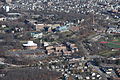
 Aerial view of South Side, Waltham, June 2015.jpg 3,992 × 2,992; 4 MB
-
 Aerial view of South Side, Waltham, May 2015.jpg 3,992 × 2,992; 4.06 MB
-
 Aerial view of The Island with snow, December 2020.jpg 8,000 × 6,000; 26.17 MB
-
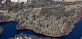
 Aerial view of The Island, Waltham, May 2020.jpg 4,048 × 3,032; 3.65 MB
-
 Brandeis University aerial 1.JPG 5,786 × 3,855; 10.67 MB
-
 Brandeis University aerial 2.JPG 6,000 × 4,000; 11.19 MB
-
 Brandeis University aerial 3.JPG 6,000 × 4,000; 11.42 MB
-
 Brandeis University aerial 4.JPG 4,000 × 6,000; 10.18 MB
-
 Brandeis University Charles River.JPG 6,000 × 4,000; 11.49 MB
-
 Cambridge Reservoir and Waltham Woods Corporate Center.JPG 4,797 × 3,205; 6.76 MB
-
 Central Waltham aerial 2.JPG 6,000 × 4,000; 11.02 MB
-
 Destruction of Cooper Street Development.jpg 3,992 × 2,992; 5.42 MB
-
 I-95 Route 20 Junction Waltham Weston MA.JPG 6,000 × 4,000; 10.38 MB
-
 I-95 Tottem Pond Road Junction Waltham MA.JPG 6,000 × 4,000; 10.5 MB
-
 Mt Feake Cemetery aerial extract.JPG 6,000 × 2,863; 5.89 MB
-
 Mt. Feake Cemetery Waltham MA aerial.JPG 6,000 × 4,000; 10.06 MB
-
 Overhead view of the The Island, August 2020.jpg 8,000 × 6,000; 18.64 MB
-
 Storm over South Side, Waltham, June 2016.jpg 3,992 × 2,992; 2.48 MB
-
 Storm over South Side, Waltham, June 2017.jpg 3,992 × 2,992; 4.69 MB
-
 Upper Charles Mount Feake Cemetery Aerial extract.JPG 4,057 × 2,701; 4.98 MB
-
 Upper Charles Mount Feake Cemetery Aerial.JPG 6,000 × 4,000; 10.88 MB
-
 Waltham aerial view 1964 postcard.jpg 1,530 × 980; 535 KB
-
 Waltham MA Aerial.JPG 6,000 × 4,000; 9.75 MB
-
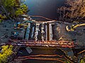 Woerd Ave bridge reconstruction, May 2020.jpg 4,048 × 3,032; 4.33 MB
-
 Woerd Avenue bridge nearing completion, November 2020.jpg 8,000 × 6,000; 27.68 MB
-
 Woerd Avenue bridge, June 2019.jpg 4,048 × 3,032; 6.42 MB


