Category:Aerial photographs of hill forts in England
Subcategories
This category has the following 3 subcategories, out of 3 total.
Media in category "Aerial photographs of hill forts in England"
The following 16 files are in this category, out of 16 total.
-
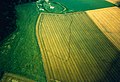
 'Aerial archaeology' from West Hill - geograph.org.uk - 1739443.jpg 1,024 × 769; 376 KB
-
 Alfred's Castle, Oxfordshire, aerial view from North.jpg 1,800 × 1,200; 324 KB
-
 Alfred's Castle, Oxfordshire, excavations 1999.jpg 839 × 573; 460 KB
-
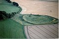
 Bredon Hill from the air - geograph.org.uk - 930027.jpg 640 × 426; 63 KB
-
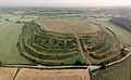
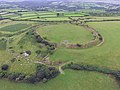 Bury Castle from the air.jpg 4,000 × 3,000; 2.42 MB
-
 Danebury Fort - aerial image, Hampshire Data Portal.jpg 2,872 × 2,536; 5.57 MB
-

-
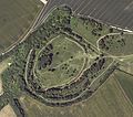
 Old Oswestry Hillfort (aerial).jpg 640 × 394; 138 KB
-
 Peace Knowe Hillfort.jpg 800 × 600; 193 KB
-
 Site of Elmley Castle from the air - geograph.org.uk - 793607.jpg 640 × 426; 51 KB
-
 St Dennis from the air.jpg 640 × 420; 73 KB
-
 St. Catherine's Hill.JPG 3,264 × 2,448; 1.9 MB
-
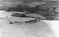
 The Mound of Down - geograph.org.uk - 1403649.jpg 640 × 427; 81 KB
-
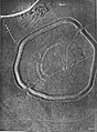 The Trundle aerial photo 1925.jpg 1,031 × 1,397; 792 KB
-
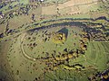
 Wiltshire-LiddingtonCastle.jpg 4,272 × 2,848; 9.46 MB
-
 Wittenham Clumps from the air, 1939.jpg 300 × 188; 12 KB


.jpg)


