Category:Aerial photographs of islands of Sweden
Media in category "Aerial photographs of islands of Sweden"
The following 18 files are in this category, out of 18 total.
-
 Almöbron 1975.tif 3,381 × 1,449; 9.34 MB
-
 Burön historiskt ortofoto.png 553 × 565; 373 KB
-
 Dekarsön historiskt ortofoto.png 374 × 476; 206 KB
-
 Fågelö i Södermanland - KMB - 16000300030712.jpg 1,944 × 2,948; 6.2 MB
-
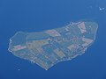
 Gotska Sandön aerial photograph.jpg 3,648 × 2,736; 3.61 MB
-
 Gotska Sandön aerial-photograph.jpg 3,648 × 2,736; 4.87 MB
-
 Kallaxön historiskt ortofoto.png 640 × 542; 367 KB
-
 Lungön historiskt ortofot.png 756 × 521; 418 KB
-
 Malmön historiskt ortofoto.png 347 × 465; 160 KB
-
 Mjältön flygfoto.tif 6,635 × 10,000; 126.55 MB
-
 Sandöbron historiskt ortofoto.png 540 × 537; 280 KB
-
 Ven IMG 1869.jpg 3,978 × 1,621; 613 KB
-
 Ven Island, Sweden.jpg 4,896 × 3,672; 4.44 MB
-
 Ven-from-east.jpg 3,971 × 2,180; 923 KB
-
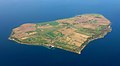
 Visingsö and Vättern aerial photograph.jpg 3,648 × 2,736; 7.68 MB
-
 Åbordsön historiskt ortofoto.png 713 × 562; 467 KB
-
 Ön–flygbild 06 september 2014.jpg 3,795 × 1,950; 6 MB
-
 Öresund - flygfoto 20190824-02.jpg 5,472 × 3,648; 6.1 MB


