Category:Aerial photographs of the Saint Lawrence River
Media in category "Aerial photographs of the Saint Lawrence River"
The following 52 files are in this category, out of 52 total.
-
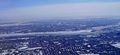
 Aerial photo 90 Montreal.jpg 2,628 × 1,884; 3.2 MB
-
 Aerial photo Montreal.jpg 2,728 × 1,260; 1.71 MB
-
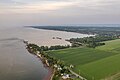 Anse de Berthier.jpg 3,925 × 2,615; 6.32 MB
-
 Arrivée à Montréal (15572903534).jpg 1,377 × 1,961; 1.83 MB
-
 Arrivée à Montréal (16194492652).jpg 1,971 × 1,423; 1.87 MB
-
 Aéroport de Trois-Rivières vu des airs.jpg 1,871 × 1,243; 401 KB
-
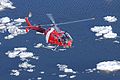 C-GCFU.jpg 3,276 × 2,184; 5.05 MB
-

-
 Cap Lauzon 2.jpg 5,464 × 3,640; 15.97 MB
-
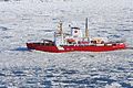 CCGS Amundsen2.jpg 2,493 × 1,662; 3.68 MB
-
 Cessna 172 pres de Trois-rivières.jpg 1,600 × 800; 1.06 MB
-
 Champ de maïs Sainte-Anne-de-la-Pérade 3.jpg 5,464 × 3,640; 19.01 MB
-
 Fleuve Saint-Laurent à Deschambault.jpg 5,464 × 3,640; 20.82 MB
-
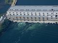 HQ - Centrale des Cèdres.jpg 2,304 × 1,728; 1.23 MB
-
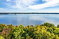
 Le fleuve Saint-Laurent.jpg 2,800 × 2,100; 1.11 MB
-
 MLH & P - Centrale de Lachine.jpg 876 × 753; 170 KB
-
 Montreal (32678741313).jpg 2,922 × 3,897; 2.79 MB
-
 Montreal (32678744793).jpg 2,894 × 3,858; 2.86 MB
-
 Montreal (33451681006).jpg 3,024 × 4,032; 3.08 MB
-
 Pont de Québec et pont Pierre-Laporte, mai 1971.jpg 1,798 × 1,164; 177 KB
-
 Québec - Pont de l'Île-d'Orléans - panoramio (1).jpg 4,000 × 3,000; 2.14 MB
-
 Québec City - Pont Pierre-Laporte - panoramio.jpg 4,000 × 3,000; 8.3 MB
-
 Québec City – Boulevard Champlain - Le Fleuve Saint-Lorent - panoramio (1).jpg 4,000 × 3,000; 2.34 MB
-
 Québec City – Lac Saint-Augustin – Le Fleuve Saint-Lorent - panoramio.jpg 4,000 × 3,000; 3.68 MB
-
 Route 132 - Notre-Dame-du-Portage - Vue aérienne.jpg 5,464 × 3,640; 15.98 MB
-
 Saint-Constant & Sainte-Catherine - vue aérienne 20170816.jpg 3,264 × 2,176; 6.82 MB
-
 Sorel-Tracy (vue aérienne) – 1.jpg 1,871 × 1,243; 482 KB
-
 Sorel-Tracy (vue aérienne) – 2.jpg 1,871 × 1,243; 396 KB
-
 Soreltracy.png 706 × 456; 566 KB
-
 St-laurent.jpg 1,253 × 1,670; 679 KB
-
 Trois-Rivières aerial 2011.jpg 1,871 × 1,243; 546 KB
-
 Trois-Rivières Airport (aerial).jpg 2,038 × 1,789; 662 KB
-
 Trou de Berthier.jpg 5,464 × 3,640; 16.47 MB
-
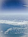
 Arrivée à Montréal (16009509967).jpg 2,272 × 1,704; 756 KB
-
 Arrivée à Montréal (16195222355).jpg 1,784 × 1,377; 1.57 MB
-
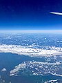
 Vol Transatlantique (16009509297).jpg 2,272 × 1,704; 777 KB
-
 Vue aerienne de montreal.JPG 2,848 × 2,128; 906 KB
-
 Vue aerienne saint laurent ile de montreal.JPG 2,314 × 1,729; 1.5 MB
-
 Vue aerienne saint laurent.JPG 1,722 × 1,286; 420 KB
-
 Vue aerienne Saint-Laurent.jpg 3,545 × 3,474; 664 KB
-
 Vue aérienne - Fleuve Saint-Laurent à Portneuf 10-2023.jpg 5,464 × 3,640; 12.71 MB
-
 Vue aérienne - Portneuf (ville) 4.jpg 5,464 × 3,640; 19.12 MB
-
 Vue aérienne - Terminal maritime de Portneuf 3.jpg 5,464 × 3,640; 16.03 MB
-
 Vue aérienne de Berthier-sur-Mer (1).jpg 4,743 × 3,159; 12.19 MB
-
 Vue aérienne de Berthier-sur-Mer (2).jpg 5,464 × 3,640; 16.76 MB
-
 Vue aérienne de Saint-André-de-Kamouraska (3).jpg 4,028 × 2,683; 8.05 MB
-
 Vue aérienne des îles de Kamouraska.jpg 4,255 × 2,834; 7.3 MB
-
 Vue aérienne Kamouraska 2023 (1).jpg 5,464 × 3,640; 15.04 MB
-
 Vue aérienne Kamouraska 2023 (2).jpg 5,464 × 3,640; 12.54 MB
-
 Vue aérienne Kamouraska 2023 (3).jpg 4,905 × 3,267; 10.88 MB
-
 Église Saint-Louis-de-Kamouraska 2023.jpg 5,464 × 3,640; 14.55 MB
-
 Île Sainte-Thérèse (fleuve Saint-Laurent) - vue aérienne 20170808.jpg 3,862 × 2,575; 4.18 MB


.jpg)
.jpg)


.jpg)
.jpg)
.jpg)

.jpg)

.jpg)


_%E2%80%93_1.jpg)
_%E2%80%93_2.jpg)


.jpg)

.jpg)
.jpg)


_4.jpg)

.jpg)
.jpg)
.jpg)

.jpg)
.jpg)
.jpg)

_-_vue_a%C3%A9rienne_20170808.jpg)
.jpg)