Category:Aerial photographs of the canton of St. Gallen
Cantons of Switzerland: Aargau (AG) · Appenzell Ausserrhoden (AR) · Appenzell Innerrhoden (AI) · Basel-Stadt (BS) · Basel-Landschaft (BL) · Bern (BE) · Fribourg (FR) · Geneva (GE) · Glarus (GL) · Graubünden (GR) · Jura (JU) · Luzern (LU) · Neuchâtel (NE) · Nidwalden (NW) · Obwalden (OW) · Schaffhausen (SH) · Schwyz (SZ) · Solothurn (SO) · St. Gallen (SG) · Thurgau (TG) · Ticino (TI) · Uri (UR) · Valais (VS) · Vaud (VD) · Zug (ZG) · Zürich (ZH)
Subcategories
This category has the following 41 subcategories, out of 41 total.
A
B
D
E
F
- Aerial photographs of Flums (3 F)
G
- Aerial photographs of Gossau SG (31 F)
J
- Aerial photographs of Jona (15 F)
L
M
- Aerial photographs of Mosnang (13 F)
N
O
- Aerial photographs of Oberriet (14 F)
Q
R
- Aerial photographs of Rebstein (18 F)
S
- Aerial photographs of Schmerikon (27 F)
T
- Aerial photographs of Thal SG (13 F)
U
- Aerial photographs of Uznach (5 F)
V
- Aerial photographs of Vättis (1 F)
W
- Aerial photographs of Widnau (10 F)
Z
Media in category "Aerial photographs of the canton of St. Gallen"
The following 67 files are in this category, out of 67 total.
-
 2011-03-07 10-01-18 Switzerland Kanton Appenzell Ausserrhoden Niederteufen.jpg 4,073 × 2,705; 4.39 MB
-
 2011-05-09 10-02-14 Switzerland Kanton St. Gallen Schwarzenbach.jpg 4,288 × 2,848; 5.78 MB
-
 2011-05-09 10-02-24 Switzerland Kanton St. Gallen Algetshausen.jpg 4,288 × 2,848; 6.75 MB
-
 2011-05-09 10-03-16 Switzerland Kanton St. Gallen Mutwil.jpg 4,095 × 2,719; 2.34 MB
-
 2011-05-09 10-03-20 Switzerland Kanton St. Gallen Mutwil.jpg 4,288 × 2,848; 6.72 MB
-
 2012-06-18 09-58-06 Switzerland Kanton St. Gallen Flawil.jpg 4,288 × 2,848; 7.49 MB
-
 2012-11-08 09-09-06 Deutschland Baden-Württemberg Isny im Allgäu Blockwiesen.JPG 3,200 × 2,125; 3.37 MB
-
 2012-11-08 09-10-56 Deutschland Baden-Württemberg Wangen im Allgäu Riehlings.JPG 3,200 × 2,125; 3.74 MB
-
 2015-01-01 12-15-44 - Switzerland Kanton St. Gallen Wildhaus Wildhaus SG QC 5h 360.jpg 12,711 × 2,242; 15.8 MB
-
 2015-01-01 12-15-44 1029.0 Switzerland Kanton St. Gallen Wildhaus QC 6h 360.jpg 13,910 × 2,675; 24.87 MB
-
 Aerial View near Gossau 14.02.2008 14-50-17.JPG 2,048 × 1,536; 1.39 MB
-
 Aerial View of a Farm near Abtwil 14.02.2008 14-49-31.JPG 2,048 × 1,536; 1.15 MB
-
 Aerial View of a Farm near Abtwil 14.02.2008 14-49-52.JPG 2,048 × 1,536; 1.4 MB
-
 Aerial View of a Farm near Brunnadern 14.02.2008 14-39-04.JPG 2,048 × 1,536; 1,013 KB
-
 Aerial View of a Farm near Gossau 14.02.2008 14-50-02.JPG 2,048 × 1,536; 1,017 KB
-
 Aerial View of a Farm near Teufen 14.02.2008 14-47-58.JPG 2,048 × 1,536; 1.39 MB
-
-
 Aerial View of Appenzell from overhead Abtwil at 4200 m asl 23.11.2008 13-55-34.JPG 1,536 × 2,048; 1.22 MB
-
 Aerial View of Appenzell from overhead Abtwil at 4280 m asl 23.11.2008 13-55-40.JPG 1,929 × 1,404; 1.09 MB
-
 Aerial View of Bronschhofen 14.02.2008 14-55-14.JPG 2,048 × 1,536; 1,007 KB
-
 Aerial View of Bronschhofen 14.02.2008 14-55-21.JPG 1,536 × 2,048; 927 KB
-
 Aerial View of Hemberg 14.02.2008 14-40-19.JPG 2,048 × 1,536; 884 KB
-
 Aerial View of Hemberg 14.02.2008 14-40-26.JPG 1,536 × 2,048; 963 KB
-
 Aerial View of Niederhelfenschwil 14.02.2008 14-52-13.JPG 2,048 × 1,536; 1.37 MB
-

-
 Aerial View of Säntis from overhead Niederbüren at 3970 m asl 23.11.2008 13-55-04.JPG 2,048 × 1,536; 1.24 MB
-
 Aerial View of the Alpstein Range overhead Niederbüren at 3870 m asl 23.11.2008 13-54-54.JPG 2,048 × 1,536; 1.11 MB
-

-
 Aerial View of Wiler Turm 14.02.2008 14-55-02.JPG 1,536 × 2,048; 1.11 MB
-
 Aerial View overhead Bronschhofen at 3130 m asl 23.11.2008 13-53-42.JPG 2,048 × 1,536; 899 KB
-
 Aerial View overhead Gossau 14.02.2008 14-50-53.JPG 2,048 × 1,536; 777 KB
-
 Aerial View overhead Hemberg 14.02.2008 14-40-03.JPG 2,048 × 1,536; 914 KB
-
 Aerial View overhead Mosnang 14.02.2008 14-36-22.JPG 2,048 × 1,536; 673 KB
-
 Aerial View overhead Mosnang 14.02.2008 14-36-29.JPG 2,048 × 1,536; 606 KB
-
 Aerial View overhead Niederbüren 14.02.2008 14-52-04.JPG 1,536 × 2,048; 862 KB
-
 Aerial View overhead Oberbüren at 3400 m asl 23.11.2008 13-54-36.JPG 2,048 × 1,536; 1.02 MB
-
 Aerial View overhead Oberbüren at 3800 m asl 23.11.2008 13-54-43.JPG 2,048 × 1,536; 861 KB
-
 Aerial View overhead Zuzwil 14.02.2008 14-53-28.JPG 2,048 × 1,536; 1,003 KB
-
 Aerial View overhead Zuzwil 14.02.2008 14-54-01.JPG 2,048 × 1,536; 1.33 MB
-
 Altenmarkt bei Sankt Gallen Drohne 2015-08-18 (mit Objektivkorrektur).jpg 3,279 × 2,459; 1.42 MB
-
 Altenmarkt bei Sankt Gallen Drohne 2015-08-18.jpg 3,320 × 2,315; 1.63 MB
-
 Benken Luftbild.jpg 2,592 × 1,944; 1.3 MB
-
 Blatten0873.jpg 3,896 × 2,922; 7.26 MB
-
 Bodensee 2018.jpg 5,184 × 3,888; 4.35 MB
-
 Brunnadern SG 1983.jpg 7,142 × 5,618; 29.03 MB
-
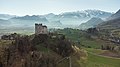 Burgruine Wartau.jpg 4,000 × 2,250; 5.06 MB
-
 Chapf-Aussenquartier-Engelburgs.jpg 800 × 600; 86 KB
-
 Discovery Luzern Zurich.jpg 1,280 × 1,024; 449 KB
-
 Engelburg-Dorfunterhälfte.jpg 800 × 600; 93 KB
-
 Engelburg-Richtung-Sittertobel.jpg 800 × 600; 93 KB
-
 ETH-BIB-Häggenschwil-Winden, Com F65-04649.tif 4,961 × 3,450; 28.29 MB
-

-
 FlugplatzSchaenisPiste34 20100605 MartinSteiger CCBYSA 001.jpg 2,592 × 1,944; 1.1 MB
-
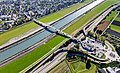 Lustenau Rheinbrücke Au Lustenau Schrägluftbild.jpg 5,000 × 3,041; 16.49 MB
-
 Mittelholzer Amden.jpg 1,868 × 2,491; 1.61 MB
-
 Mittelholzer Ziegelbrücke vor 1920.jpg 2,937 × 1,967; 2.01 MB
-
 Mogelsberg 1980.jpg 3,426 × 2,693; 4.11 MB
-
 Mäder Rheinbrücke Schrägluftbild.jpg 4,500 × 2,968; 12.7 MB
-
 St. Galler Rheintal (8320174393).jpg 4,000 × 2,248; 1.6 MB
-
 St. Georgs-Kapelle (Berschis) DJI 0839.jpg 4,000 × 2,250; 4.21 MB
-
 Swiss Alps As Seen From Secretary Kerry's Helicopter (12137112955).jpg 2,594 × 1,721; 1.58 MB
-
 Säntis-Nord-Panorama beschriftet.jpg 648 × 486; 90 KB
-
 Säntis-Nord-Panorama.jpg 1,296 × 972; 281 KB
-
 Walensee Bergketten.jpg 4,000 × 2,250; 6.34 MB
-
 Walenstadt Richtung Sargans.jpg 1,000 × 750; 856 KB
-
 Walenstadt Walesee DJI 0854.jpg 2,855 × 1,605; 1.03 MB
-
 Wasserfluh Neu-Toggenburg.tif 4,500 × 3,000; 38.67 MB


.jpg)


.jpg)
_DJI_0839.jpg)
.jpg)


