Category:Ajuntament de Falset
| Object location | | View all coordinates using: OpenStreetMap |
|---|
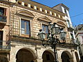
municipal building in Falset, Spain  | |||||
| Upload media | |||||
| Instance of | |||||
|---|---|---|---|---|---|
| Location | Falset, Priorat, Camp de Tarragona, Tarragona Province, Catalonia | ||||
| Architectural style | |||||
| Owned by | |||||
| Occupant | |||||
| Heritage designation |
| ||||
 | |||||
Català: Ajuntament de Falset (Priorat)
This is a category about a building listed in the Catalan heritage register as Bé Cultural d'Interès Local (BCIL) under the reference IPA-11176. |
Subcategories
This category has only the following subcategory.
Media in category "Ajuntament de Falset"
The following 7 files are in this category, out of 7 total.
-
 Ajuntament de Falset - 1.jpg 4,466 × 3,072; 5.68 MB
-
 Casa de la vila de Falset.jpg 3,096 × 4,128; 4.37 MB
-
 E03 L'Ajuntament des dels porxos de la plaça de la Quartera.jpg 1,536 × 2,048; 824 KB
-
 E04 Ajuntament, antic palau dels Comtes de Prades.jpg 2,048 × 1,536; 901 KB
-
 E05 Porxos de l'Ajuntament.jpg 2,048 × 1,536; 865 KB
-
 Falset (1), plaça de la Quartera, Ajuntament.jpg 3,456 × 2,592; 4.38 MB
-
 Falset. Ajuntament 1.JPG 1,944 × 2,592; 1.15 MB


,_pla%C3%A7a_de_la_Quartera,_Ajuntament.jpg)