Category:Alde Swarte
| Object location | | View all coordinates using: OpenStreetMap |
|---|
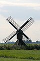
windmill in Wieuwens, Netherlands  | |||||
| Upload media | |||||
| Instance of | |||||
|---|---|---|---|---|---|
| Location | Wieuwens, Leeuwarden, Friesland, Netherlands | ||||
| Street address |
| ||||
| Has use |
| ||||
| Heritage designation |
| ||||
| Source of energy | |||||
 | |||||
Nederlands: Alde Swarte
|
This is a category about rijksmonument number 8531
|
| Address |
|
Media in category "Alde Swarte"
The following 5 files are in this category, out of 5 total.
-
 Oosterlittens - Alde Swarte - Wieuwens.jpg 1,300 × 1,950; 1.4 MB
-
 Spinnekopmolen, overzicht - Oosterlittens - 20175126 - RCE.jpg 1,200 × 1,167; 197 KB
-
 Spinnekopmolen, overzicht - Oosterlittens - 20175127 - RCE.jpg 1,200 × 1,172; 217 KB
-
 Watermolen aan de Franekervaart - Oosterlittens - 20175124 - RCE.jpg 1,200 × 784; 142 KB
-
 Watermolen aan de Franekervaart - Oosterlittens - 20175125 - RCE.jpg 1,200 × 788; 149 KB


