Category:Allée couverte de Minguionnet
|
This building is classé au titre des monuments historiques de la France. It is indexed in the base Mérimée, a database of architectural heritage maintained by the French Ministry of Culture, under the reference PA00091205
|
| Object location | | View all coordinates using: OpenStreetMap |
|---|
gallery grave in Gourin, France  | |||||
| Upload media | |||||
| Instance of | |||||
|---|---|---|---|---|---|
| Location | Gourin, Morbihan, Brittany, Q88521114, Metropolitan France, France | ||||
| Street address |
| ||||
| Heritage designation |
| ||||
 | |||||
Media in category "Allée couverte de Minguionnet"
The following 3 files are in this category, out of 3 total.
-
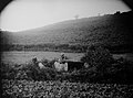 110 Auguste Barbey Gourin Allée couverte.jpg 2,451 × 1,821; 1.89 MB
-
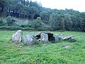 Gourin allée couverte.JPG 4,320 × 3,240; 4.7 MB
-
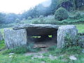 Gourin Minguionnet table.JPG 4,320 × 3,240; 4.69 MB

