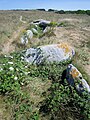
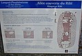
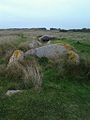
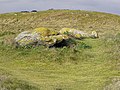
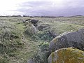
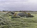
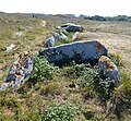
Category:Allée couverte de Pont-ar-Bleiz (Lampaul-Ploudalmézeau)
|
This building is classé au titre des monuments historiques de la France. It is indexed in the base Mérimée, a database of architectural heritage maintained by the French Ministry of Culture, under the reference PA00090021
|
| Object location | | View all coordinates using: OpenStreetMap |
|---|
_Mougev_ar_Ribl_03.JPG) | |||||
| Upload media | |||||
| Instance of | |||||
|---|---|---|---|---|---|
| Location | Lampaul-Ploudalmézeau, canton of Ploudalmézeau | ||||
| Heritage designation |
| ||||
 | |||||
Media in category "Allée couverte de Pont-ar-Bleiz (Lampaul-Ploudalmézeau)"
The following 11 files are in this category, out of 11 total.
-
 365 Lampaul-Ploudalmézeau Allée couverte du Ribl.jpg 3,240 × 4,320; 6.02 MB
-
 366 Lampaul-Ploudalmézeau Allée couverte du Ribl.jpg 3,112 × 2,126; 2.53 MB
-
 Allée couverte du Ribl.jpg 768 × 1,024; 167 KB
-
 Lambaol-Gwitalmeze (29) Mougev ar Ribl 01.JPG 1,191 × 893; 1.21 MB
-
 Lambaol-Gwitalmeze (29) Mougev ar Ribl 02.JPG 1,191 × 893; 1.02 MB
-
 Lambaol-Gwitalmeze (29) Mougev ar Ribl 03.JPG 1,191 × 893; 1.05 MB
-
 Lambaol-Gwitalmeze (29) Mougev ar Ribl 04.JPG 1,191 × 893; 758 KB
-
 Lambaol-Gwitalmeze (29) Mougev ar Ribl 05.JPG 1,191 × 893; 960 KB
-
 Lampaul-ploudalmézeau alc-pont-ar-bleiz 01.jpg 4,980 × 4,593; 3.75 MB
-
 Lampaul-ploudalmézeau alc-pont-ar-bleiz 02.jpg 7,439 × 3,027; 4.18 MB
-
 Lampaul-ploudalmézeau alc-pont-ar-bleiz 03.jpg 4,608 × 3,072; 2.96 MB


_Mougev_ar_Ribl_01.JPG)
_Mougev_ar_Ribl_02.JPG)
_Mougev_ar_Ribl_04.JPG)
_Mougev_ar_Ribl_05.JPG)

