Category:Allersmaborg, Ezinge
| Object location | | View all coordinates using: OpenStreetMap |
|---|
hamlet in Het Hogeland, Netherlands  | |||||
| Upload media | |||||
| Spoken text audio | |||||
|---|---|---|---|---|---|
| Instance of | |||||
| Part of | |||||
| Location |
| ||||
| Street address |
| ||||
| Located on street | |||||
| Heritage designation |
| ||||
 | |||||
Nederlands: Allersmaborg
|
This is a category about rijksmonumentcomplex number 510903
|
Borg
|
This is a category about rijksmonument number 15537
|
Dienstwoning ("klerkenwoning", "klerkenhuis") (ca. 1880)
|
This is a category about rijksmonument number 510921
|
Prieel (ca. 1915)
|
This is a category about rijksmonument number 510922
|
| Address |
|
Subcategories
This category has the following 2 subcategories, out of 2 total.
D
- Duiventoren, Allersmaborg (5 F)
P
- Prieel, Allersmaborg (6 F)
Media in category "Allersmaborg, Ezinge"
The following 98 files are in this category, out of 98 total.
-
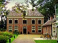
 20090228 Allersmaborg Groningen NL.jpg 4,223 × 2,425; 7.23 MB
-
 A. Schouman - Het Huys te Allersma.jpg 4,010 × 2,748; 995 KB
-
 Allersma - kaart Apken 1822.jpg 6,117 × 7,380; 7.86 MB
-
 Allersma - uitsnede kaart 1822.jpg 458 × 384; 89 KB
-
 Allersma borg..JPG 3,456 × 4,608; 3.14 MB
-
 Allersmaborg (1).jpg 4,896 × 3,264; 17.05 MB
-
 Allersmaborg (2).jpg 4,606 × 3,264; 15.49 MB
-
 Allersmaborg (34705939841).jpg 1,536 × 1,024; 1.79 MB
-
 Allersmaborg - boomgaard.jpg 4,843 × 3,011; 12.18 MB
-
 Allersmaborg - Dirk Rudolph de Marees van Swinderen in de tweede suite.jpg 2,641 × 1,993; 1.13 MB
-
 Allersmaborg - klapbrug, duiventil, kas en klerkenhuis.jpg 3,834 × 2,831; 3.14 MB
-
 Allersmaborg - oude koetshuis.jpg 3,846 × 2,774; 3.16 MB
-
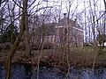
 Allersmaborg - schuin van achteren.jpg 4,000 × 3,000; 10.2 MB
-
 Allersmaborg-Entree.JPG 2,457 × 1,835; 1.91 MB
-
 Allersmaborg.De voorgevel..JPG 4,608 × 3,456; 4.2 MB
-
 Allersmaborg.JPG 1,808 × 1,184; 914 KB
-
 Allersmaborg1.jpg 608 × 456; 84 KB
-
 Allersmaborg2.jpg 608 × 456; 82 KB
-
 Anna Elema.jpg 4,822 × 6,400; 1.24 MB
-
 Bijgebouw.JPG 4,608 × 3,456; 1.81 MB
-
 Brug herfst.jpg 3,072 × 2,304; 3.15 MB
-
 Brug voorjaar.jpg 3,648 × 2,736; 1.13 MB
-
 Buitenplaats met Reflectie.JPG 3,456 × 4,608; 1.67 MB
-
 Dienstwoning achter de borg.JPG 4,608 × 3,456; 1.82 MB
-
 Duurt Sirps Elema Tho Allersma.jpg 4,939 × 6,400; 2.36 MB
-
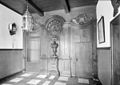 Eiken schot in hal en kelder - Ezinge - 20073179 - RCE.jpg 1,200 × 847; 173 KB
-
 Eiken schot in hal en kelder - Ezinge - 20073180 - RCE.jpg 1,200 × 932; 197 KB
-
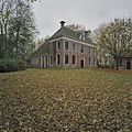
 Exterieur vanuit het zuid-oosten - Ezinge - 20073177 - RCE.jpg 1,200 × 834; 270 KB
-
 Gevelaanzicht - Ezinge - 20073181 - RCE.jpg 1,200 × 973; 269 KB
-
 Gevelaanzicht - Ezinge - 20073182 - RCE.jpg 1,193 × 1,200; 394 KB
-
 Gevelaanzicht - Ezinge - 20073183 - RCE.jpg 1,197 × 1,200; 466 KB
-
 Gevels van het koetshuis - Ezinge - 20380886 - RCE.jpg 1,200 × 1,200; 431 KB
-
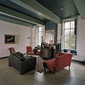
 Interieur betimmering - Ezinge - 20324158 - RCE.jpg 1,200 × 857; 166 KB
-

-

-
 Interieur, fonteintje in de ontvangsthal - Ezinge - 20380726 - RCE.jpg 1,200 × 1,200; 256 KB
-

-
 Interieur, kamer op bovenverdieping - Ezinge - 20380877 - RCE.jpg 1,200 × 1,200; 194 KB
-
 Interieur, kamer op bovenverdieping links van het midden - Ezinge - 20380872 - RCE.jpg 1,200 × 1,200; 176 KB
-
 Interieur, kamer op bovenverdieping met kastenwand - Ezinge - 20380874 - RCE.jpg 1,200 × 1,200; 192 KB
-
 Interieur, kamer op bovenverdieping rechts - Ezinge - 20380871 - RCE.jpg 1,200 × 1,200; 202 KB
-
 Interieur, kastenwand in de kelder - Ezinge - 20380866 - RCE.jpg 1,200 × 1,200; 234 KB
-
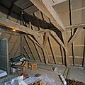
 Interieur, overzicht van de gordingenkap - Ezinge - 20380879 - RCE.jpg 1,200 × 1,200; 245 KB
-
 Interieur, overzicht van de kap - Ezinge - 20380878 - RCE.jpg 1,200 × 1,200; 294 KB
-
 Interieur, overzicht van de kapconstructie - Ezinge - 20380880 - RCE.jpg 1,200 × 1,200; 259 KB
-
 Interieur, overzicht van de kapconstructie - Ezinge - 20380881 - RCE.jpg 1,200 × 1,200; 252 KB
-
 Interieur, overzicht van de kelder met trap en kastenwand - Ezinge - 20380869 - RCE.jpg 1,200 × 1,195; 276 KB
-

-
 Interieur, overzicht van de ontvangsthal met fontein - Ezinge - 20380724 - RCE.jpg 1,200 × 1,200; 230 KB
-
 Interieur, overzicht van gang op de begane grond - Ezinge - 20380734 - RCE.jpg 1,200 × 1,200; 198 KB
-

-
 Interieur, overzicht van kelder met oude potkachels - Ezinge - 20380863 - RCE.jpg 1,200 × 1,200; 230 KB
-
 Interieur, overzicht van middenkamer links - Ezinge - 20380732 - RCE.jpg 1,200 × 1,200; 175 KB
-
 Interieur, overzicht van vensters in middenkamer links - Ezinge - 20380862 - RCE.jpg 1,200 × 1,200; 261 KB
-
 Interieur, overzicht van vertrek links boven - Ezinge - 20380728 - RCE.jpg 1,200 × 1,200; 203 KB
-
 Interieur, overzicht van vertrek links voor - Ezinge - 20380730 - RCE.jpg 1,200 × 1,200; 188 KB
-
 Interieur, overzicht van vertrek links voor met schouw - Ezinge - 20380731 - RCE.jpg 1,200 × 1,200; 203 KB
-
 Interieur, overzicht van vertrek rechts achter - Ezinge - 20380729 - RCE.jpg 1,200 × 1,200; 197 KB
-

-
 Interieur, plafondbalk met sleutelstuk, in de kelder - Ezinge - 20380867 - RCE.jpg 1,200 × 1,200; 256 KB
-
 Interieur, schouw in de kelder, met potkachels - Ezinge - 20380864 - RCE.jpg 1,200 × 1,200; 196 KB
-
 Interieur, trap in de kelder - Ezinge - 20380865 - RCE.jpg 1,200 × 1,200; 240 KB
-
 Interieur, waterpomp in de kelder - Ezinge - 20380868 - RCE.jpg 1,200 × 1,200; 242 KB
-
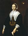 Meenwertien Fockens.jpg 5,012 × 6,400; 1.11 MB
-
Nl-Allersmaborg-article.ogg 1 min 40 s; 990 KB
-
 Overzicht gang in klerkenwoning - Ezinge - 20380903 - RCE.jpg 1,200 × 1,200; 156 KB
-
 Overzicht gang in koetshuis - Ezinge - 20380905 - RCE.jpg 1,200 × 1,200; 176 KB
-
 Overzicht gracht met de klerkenwoning - Ezinge - 20380885 - RCE.jpg 1,200 × 1,200; 417 KB
-
 Overzicht keuken in klerkenwoning - Ezinge - 20380902 - RCE.jpg 1,148 × 1,200; 162 KB
-
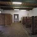
 Overzicht paardenbox in koetshuis - Ezinge - 20380904 - RCE.jpg 1,200 × 1,200; 257 KB
-
 Overzicht ruimte achter de paardenbox in koetshuis - Ezinge - 20380906 - RCE.jpg 1,200 × 1,200; 235 KB
-
 Overzicht ruimte achter de paardenbox in koetshuis - Ezinge - 20380907 - RCE.jpg 1,200 × 1,200; 238 KB
-
 Overzicht van de hoofdentree - Ezinge - 20380716 - RCE.jpg 1,200 × 1,200; 434 KB
-
 Overzicht van de klerkenwoning met gedeelte van prieel - Ezinge - 20380719 - RCE.jpg 1,200 × 1,200; 443 KB
-

-
 Overzicht van de rechterzijgevels met gedeelte van gracht - Ezinge - 20380718 - RCE.jpg 1,200 × 1,200; 401 KB
-
-

-
 Overzicht van paardenbox in het koetshuis - Ezinge - 20380897 - RCE.jpg 1,200 × 1,200; 217 KB
-
 Overzicht van rechterzijgevel achterhuis - Ezinge - 20380890 - RCE.jpg 1,200 × 1,200; 494 KB
-
 Overzicht vertrek in klerkenwoning - Ezinge - 20380900 - RCE.jpg 1,200 × 1,200; 184 KB
-
 Overzicht vertrek in klerkenwoning - Ezinge - 20380901 - RCE.jpg 1,200 × 1,200; 204 KB
-
 Overzicht voorgevels van het koetshuis - Ezinge - 20380894 - RCE.jpg 1,200 × 1,200; 485 KB
-

-
 Overzicht zijgevel van de klerkenwoning - Ezinge - 20380884 - RCE.jpg 1,200 × 1,200; 435 KB
-
 Plattegrond 1822 - Ezinge - 20073178 - RCE.jpg 832 × 1,200; 169 KB
-
 Rechterzijgevel woonhuis, grachtzijde - Ezinge - 20380895 - RCE.jpg 1,200 × 1,200; 425 KB
-
 Reneke de Marees van Swinderen (1764-1848).jpg 600 × 818; 116 KB
-
 Reneke Meinard Adriaan de Marees van Swinderen.jpg 2,021 × 2,646; 1.43 MB
-
 Vertrek in het koetshuis - Ezinge - 20380898 - RCE.jpg 1,200 × 1,200; 185 KB
-
 Vliet nabij de Borg - Ezinge - 20073185 - RCE.jpg 1,193 × 1,200; 434 KB
-
 Waterpomp in het koetshuis - Ezinge - 20380899 - RCE.jpg 1,200 × 1,200; 209 KB
-
 Zicht op de ophaalbrug - Ezinge - 20380723 - RCE.jpg 1,200 × 1,200; 548 KB
-
 Zicht op de voorzijde - Ezinge - 20073184 - RCE.jpg 1,197 × 1,200; 373 KB
-
 Zicht op de zijgevel - Ezinge - 20073186 - RCE.jpg 1,200 × 1,197; 408 KB
-
 Zicht op het plaatsje achter het woonhuis - Ezinge - 20380896 - RCE.jpg 1,200 × 1,200; 455 KB
-
 Zicht op huis met duiventoren en ophaalbrug - Ezinge - 20380698 - RCE.jpg 1,200 × 1,200; 586 KB
-
 Zicht richting huis met ophaalbrug - Ezinge - 20380700 - RCE.jpg 1,200 × 1,200; 486 KB


.jpg)
.jpg)
.jpg)


.jpg)


