Category:Allhallows, Kent
village and civil parish on the Hoo Peninsula in Kent, England  | |||||
| Upload media | |||||
| Instance of | |||||
|---|---|---|---|---|---|
| Location | Medway, Kent, South East England, England | ||||
| Located in or next to body of water | |||||
| Inception |
| ||||
 | |||||
Subcategories
This category has the following 4 subcategories, out of 4 total.
A
- Allhallows-on-Sea (9 F)
S
- Slough Fort (7 F)
Media in category "Allhallows, Kent"
The following 200 files are in this category, out of 619 total.
(previous page) (next page)-
 A dead horse and a dead railway - geograph.org.uk - 4090989.jpg 4,000 × 3,000; 3.78 MB
-
 A field of wheat - geograph.org.uk - 3022837.jpg 640 × 430; 68 KB
-
 A former horse buried near a former railway - geograph.org.uk - 4091376.jpg 4,000 × 3,000; 4.04 MB
-

-
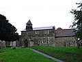 All Saints Church, Allhallows - geograph.org.uk - 3738057.jpg 3,488 × 2,616; 2.28 MB
-
 All Saints Rd - geograph.org.uk - 3024616.jpg 640 × 430; 62 KB
-
 All Saints Road, Allhallows - geograph.org.uk - 3738056.jpg 3,488 × 2,616; 2.23 MB
-
 All Saints' Rd - geograph.org.uk - 3024582.jpg 640 × 430; 63 KB
-
 All Saints' Rd - geograph.org.uk - 3024585.jpg 640 × 430; 70 KB
-
 All Saints, Allhallows - Chancel - geograph.org.uk - 3468653.jpg 1,000 × 667; 188 KB
-
 All Saints, Allhallows - Decalogue - geograph.org.uk - 3468651.jpg 970 × 1,000; 289 KB
-
 All Saints, Allhallows - East end - geograph.org.uk - 3468654.jpg 1,000 × 667; 188 KB
-
 All Saints, Allhallows - East end - geograph.org.uk - 3468655.jpg 1,000 × 620; 185 KB
-
 All Saints, Allhallows - Font - geograph.org.uk - 3468648.jpg 667 × 1,000; 157 KB
-
 All Saints, Allhallows - geograph.org.uk - 3468466.jpg 1,000 × 723; 218 KB
-
 All Saints, Allhallows - geograph.org.uk - 3468478.jpg 1,000 × 634; 254 KB
-
 All Saints, Allhallows - Gravestones - geograph.org.uk - 3468647.jpg 1,000 × 698; 297 KB
-
 All Saints, Allhallows - Stained glass window - geograph.org.uk - 3468652.jpg 547 × 1,000; 230 KB
-
 All Saints, Allhallows - War Memorial WWI ^ WWII - geograph.org.uk - 3468649.jpg 1,000 × 721; 209 KB
-
 Allhallow Marshes - geograph.org.uk - 3020609.jpg 640 × 430; 63 KB
-
 Allhallows Caravan Park - geograph.org.uk - 3040883.jpg 640 × 430; 50 KB
-
 Allhallows Holiday Park - geograph.org.uk - 3039367.jpg 640 × 351; 40 KB
-
 Allhallows Holiday Park - geograph.org.uk - 3039377.jpg 640 × 430; 55 KB
-
 Allhallows Holiday Park - geograph.org.uk - 3039383.jpg 640 × 374; 38 KB
-
 Allhallows Holiday Park - geograph.org.uk - 3039387.jpg 640 × 388; 39 KB
-
 Allhallows Holiday Park - geograph.org.uk - 3040851.jpg 640 × 430; 53 KB
-
 Allhallows Holiday Park - geograph.org.uk - 3040853.jpg 640 × 430; 57 KB
-
 Allhallows Holiday Park - geograph.org.uk - 3040862.jpg 640 × 430; 52 KB
-
 Allhallows Holiday Park - geograph.org.uk - 3040867.jpg 640 × 430; 101 KB
-
 Allhallows Leisure Park, Allhallows-on-Sea - geograph.org.uk - 6069801.jpg 1,024 × 768; 118 KB
-
 Allhallows Marshes - geograph.org.uk - 2991133.jpg 640 × 430; 61 KB
-
 Allhallows Marshes - geograph.org.uk - 2991134.jpg 640 × 391; 45 KB
-
 Allhallows Marshes - geograph.org.uk - 2991161.jpg 640 × 430; 62 KB
-
 Allhallows Marshes - geograph.org.uk - 2991195.jpg 640 × 430; 64 KB
-
 Allhallows Marshes - geograph.org.uk - 2993175.jpg 640 × 430; 67 KB
-
 Allhallows Marshes - geograph.org.uk - 2996564.jpg 640 × 405; 56 KB
-
 Allhallows Marshes - geograph.org.uk - 3001953.jpg 640 × 430; 61 KB
-
 Allhallows Marshes - geograph.org.uk - 3004753.jpg 640 × 430; 58 KB
-
 Allhallows Marshes - geograph.org.uk - 3004791.jpg 640 × 403; 59 KB
-
 Allhallows Marshes - geograph.org.uk - 3004808.jpg 640 × 430; 71 KB
-
 Allhallows Marshes - geograph.org.uk - 3004810.jpg 640 × 430; 69 KB
-
 Allhallows Marshes - geograph.org.uk - 3011251.jpg 640 × 430; 67 KB
-
 Allhallows Marshes - geograph.org.uk - 3013410.jpg 640 × 430; 60 KB
-
 Allhallows Marshes - geograph.org.uk - 3013418.jpg 640 × 430; 59 KB
-
 Allhallows Marshes - geograph.org.uk - 3016942.jpg 640 × 430; 56 KB
-
 Allhallows Marshes - geograph.org.uk - 3016951.jpg 640 × 430; 60 KB
-
 Allhallows Marshes - geograph.org.uk - 3016959.jpg 640 × 399; 37 KB
-
 Allhallows Marshes - geograph.org.uk - 3016963.jpg 640 × 430; 54 KB
-
 Allhallows Marshes - geograph.org.uk - 3016976.jpg 640 × 430; 70 KB
-
 Allhallows Marshes - geograph.org.uk - 3016977.jpg 640 × 430; 52 KB
-
 Allhallows Marshes - geograph.org.uk - 3016982.jpg 640 × 430; 45 KB
-
 Allhallows Marshes - geograph.org.uk - 3016984.jpg 640 × 430; 47 KB
-
 Allhallows Marshes - geograph.org.uk - 3020607.jpg 640 × 430; 58 KB
-
 Allhallows Marshes - geograph.org.uk - 3020612.jpg 640 × 430; 69 KB
-
 Allhallows Marshes - geograph.org.uk - 3020616.jpg 640 × 388; 57 KB
-
 Allhallows Marshes - geograph.org.uk - 3020624.jpg 640 × 430; 53 KB
-
 Allhallows Marshes - geograph.org.uk - 3022820.jpg 640 × 430; 67 KB
-
 Allhallows Marshes - geograph.org.uk - 3889336.jpg 3,488 × 2,616; 2.2 MB
-
 Allhallows Marshes - geograph.org.uk - 3889338.jpg 3,488 × 2,616; 2.19 MB
-
 Allhallows Marshes - geograph.org.uk - 3889343.jpg 3,488 × 2,616; 2.22 MB
-
 Allhallows Marshes - geograph.org.uk - 3889364.jpg 3,488 × 2,616; 2.18 MB
-
 Allhallows Marshes - geograph.org.uk - 3889365.jpg 3,488 × 2,616; 2.14 MB
-
 Allhallows Marshes - geograph.org.uk - 3889371.jpg 3,488 × 2,616; 2.19 MB
-
 Allhallows Marshes - geograph.org.uk - 3889387.jpg 3,488 × 2,616; 2.19 MB
-
 Allhallows Marshes - geograph.org.uk - 4091591.jpg 4,000 × 3,000; 4.2 MB
-
 Allhallows Marshes - geograph.org.uk - 4965303.jpg 3,264 × 2,448; 1.55 MB
-
 Allhallows Marshes - geograph.org.uk - 4965306.jpg 3,264 × 2,448; 1.73 MB
-
 Allhallows Marshes - geograph.org.uk - 4965307.jpg 3,264 × 2,448; 2.23 MB
-
 Allhallows Marshes - geograph.org.uk - 4965309.jpg 3,264 × 2,448; 3.16 MB
-
 Allhallows Marshes - geograph.org.uk - 4965310.jpg 3,264 × 2,448; 1.62 MB
-
 Allhallows Marshes - geograph.org.uk - 4965311.jpg 3,264 × 2,448; 1.69 MB
-
 Allhallows Marshes - geograph.org.uk - 4965313.jpg 3,155 × 2,367; 1.41 MB
-
 Allhallows Marshes - geograph.org.uk - 4965315.jpg 3,083 × 2,313; 1.67 MB
-
 Allhallows Marshes - geograph.org.uk - 4965316.jpg 3,264 × 2,448; 1.71 MB
-
 Allhallows Marshes - geograph.org.uk - 4965645.jpg 3,264 × 2,448; 1.91 MB
-
 Allhallows Marshes - geograph.org.uk - 4965647.jpg 3,155 × 2,367; 2.06 MB
-
 Allhallows Marshes - geograph.org.uk - 4965650.jpg 3,139 × 2,355; 2.3 MB
-
 Allhallows Marshes - geograph.org.uk - 4965653.jpg 3,264 × 2,448; 1.84 MB
-
 Allhallows Marshes - geograph.org.uk - 4965681.jpg 3,264 × 2,448; 2 MB
-
 Allhallows on Sea - geograph.org.uk - 2991146.jpg 640 × 430; 61 KB
-
 Allhallows Pillbox - geograph.org.uk - 268428.jpg 640 × 426; 99 KB
-
 Allhallows Post Office - geograph.org.uk - 3040872.jpg 640 × 430; 58 KB
-
 Allhallows Sailing Club - geograph.org.uk - 3039349.jpg 640 × 430; 77 KB
-
 Allhallows seen across the marshes - geograph.org.uk - 2996538.jpg 640 × 378; 47 KB
-
 Allhallows Village Sign - geograph.org.uk - 4958722.jpg 2,448 × 3,264; 1.68 MB
-
 Allhallows-on-Sea, looking north-east - geograph.org.uk - 2779878.jpg 1,600 × 1,066; 326 KB
-

-
 AllhallowsRose&Crown5040.JPG 2,048 × 1,536; 789 KB
-

-
 An old river course - geograph.org.uk - 2991145.jpg 640 × 430; 75 KB
-
 Apartments, Allhallows - geograph.org.uk - 3040876.jpg 640 × 430; 49 KB
-
 Avery Rd - geograph.org.uk - 3040870.jpg 640 × 430; 57 KB
-
 Avery Rd - geograph.org.uk - 3040873.jpg 640 × 430; 56 KB
-
 Avery Way - geograph.org.uk - 2971480.jpg 640 × 390; 38 KB
-
 Avery Way - geograph.org.uk - 2991109.jpg 640 × 430; 67 KB
-
 Avery Way - geograph.org.uk - 3024622.jpg 640 × 430; 55 KB
-
 Avery Way, Allhallows - geograph.org.uk - 1351836.jpg 640 × 480; 47 KB
-
 Avery Way, Allhallows - geograph.org.uk - 2971474.jpg 640 × 386; 40 KB
-
 Avery Way, Allhallows - geograph.org.uk - 2971476.jpg 640 × 430; 49 KB
-
 Avery Way, Allhallows - geograph.org.uk - 3738039.jpg 3,488 × 2,616; 2.12 MB
-
 Avery Way, Allhallows - geograph.org.uk - 6069783.jpg 1,024 × 768; 154 KB
-
 Avery Way, Allhallows on Sea - geograph.org.uk - 2971471.jpg 640 × 396; 40 KB
-
 Avery Way, Allhallows-on-Sea - geograph.org.uk - 4965739.jpg 3,264 × 2,448; 1.86 MB
-
 Avery Way, Allhallows-on-Sea - geograph.org.uk - 4965740.jpg 3,125 × 2,345; 1.64 MB
-
 Avery Way, Allhallows-on-Sea - geograph.org.uk - 6069793.jpg 1,024 × 768; 118 KB
-
 Avery Way, Allhallows-on-Sea - geograph.org.uk - 6069833.jpg 1,024 × 768; 130 KB
-
 Barn, Binney Farm - geograph.org.uk - 3020656.jpg 640 × 430; 87 KB
-
 Barn, Binney Farm - geograph.org.uk - 3022810.jpg 640 × 430; 58 KB
-
 Barns at Brickhouse Farm - geograph.org.uk - 2302785.jpg 1,024 × 768; 158 KB
-
 Beach, Allhallows - geograph.org.uk - 3040858.jpg 640 × 430; 74 KB
-
 Beach, Thames Estuary - geograph.org.uk - 3034543.jpg 640 × 430; 71 KB
-
 Beach, Thames Estuary - geograph.org.uk - 3035904.jpg 640 × 430; 75 KB
-
 Beatty Cottages, Allhallows - geograph.org.uk - 3738060.jpg 3,488 × 2,616; 2.12 MB
-
 Beatty Cottages, Stoke Road, Allhallows - geograph.org.uk - 4958707.jpg 3,264 × 2,448; 1.55 MB
-
 Bed of an old railway line - geograph.org.uk - 3022824.jpg 640 × 430; 74 KB
-

-
 Bend in the Old Counter Wall - geograph.org.uk - 3011307.jpg 640 × 430; 61 KB
-
 Binney Farm, Allhallows - geograph.org.uk - 5156444.jpg 640 × 428; 140 KB
-
 Binney Rd - geograph.org.uk - 3024562.jpg 640 × 430; 74 KB
-
 Binney Rd - geograph.org.uk - 3024566.jpg 640 × 430; 88 KB
-
 Binney Road - geograph.org.uk - 4090961.jpg 4,000 × 3,000; 3.98 MB
-
 Binney Road, Allhallows - geograph.org.uk - 3738047.jpg 3,488 × 2,616; 2.3 MB
-
 Binney Road, Allhallows - geograph.org.uk - 3738048.jpg 3,488 × 2,616; 2.25 MB
-
 Binney Road, Allhallows - geograph.org.uk - 3738050.jpg 3,488 × 2,616; 2.22 MB
-
 Binney Road, Allhallows - geograph.org.uk - 3738054.jpg 3,488 × 2,616; 2.2 MB
-
 Binney Road, Allhallows - geograph.org.uk - 4958655.jpg 3,264 × 2,448; 1.94 MB
-
 Binney Road, Allhallows - geograph.org.uk - 4958667.jpg 3,264 × 2,448; 1.63 MB
-
 Binney Road, Allhallows - geograph.org.uk - 4958697.jpg 3,264 × 2,448; 2.59 MB
-
 Binney Road, Allhallows - geograph.org.uk - 4958701.jpg 3,264 × 2,448; 1.61 MB
-
 Brickhouse Farm - geograph.org.uk - 3030149.jpg 640 × 430; 63 KB
-
 Brickhouse Farm - geograph.org.uk - 3606458.jpg 4,000 × 3,000; 4.3 MB
-
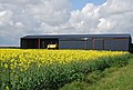
 Brickhouse Farm in a sea of yellow - geograph.org.uk - 3030160.jpg 640 × 430; 66 KB
-
 British Pilot - geograph.org.uk - 2991105.jpg 640 × 430; 80 KB
-
 British Pilot TQ8478 327.jpg 2,048 × 1,536; 652 KB
-
 Buildings near Yantlet Creek Wharf - geograph.org.uk - 2999226.jpg 640 × 430; 46 KB
-
 Bus stop, Allhallows - geograph.org.uk - 3040880.jpg 640 × 369; 35 KB
-
 Byway heading north - geograph.org.uk - 3030171.jpg 640 × 430; 60 KB
-
 Byway to Allhallows - geograph.org.uk - 3022832.jpg 640 × 430; 68 KB
-

-
 Cattle alongside Yantlet Creek - geograph.org.uk - 4100129.jpg 4,000 × 3,000; 4.13 MB
-
 Cattle grazing on Alhallows Marshes - geograph.org.uk - 3889363.jpg 3,488 × 2,616; 1.78 MB
-
 Cattle on Allhallows Marshes - geograph.org.uk - 3011254.jpg 640 × 378; 44 KB
-
 Cattle on Allhallows Marshes - geograph.org.uk - 5156298.jpg 640 × 480; 204 KB
-
 Cattle on the marshes - geograph.org.uk - 3011301.jpg 640 × 430; 66 KB
-
 Cattle on the sea wall by Yantlet Creek - geograph.org.uk - 4100133.jpg 4,000 × 3,000; 4.07 MB
-
 Cattle on the sea wall by Yantlet Creek - geograph.org.uk - 4100143.jpg 4,000 × 3,000; 4.17 MB
-
 Cattle on the sea wall overlooking Allhallows Marshes - geograph.org.uk - 4100137.jpg 4,000 × 3,000; 4.32 MB
-
 Cattle, Allhallows Marshes - geograph.org.uk - 3011260.jpg 640 × 303; 39 KB
-
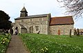
 Church of All Saints, Allhallows - geograph.org.uk - 3024593.jpg 640 × 430; 115 KB
-
 Church of All Saints, Allhallows - geograph.org.uk - 3024595.jpg 640 × 430; 101 KB
-
 Church of All Saints, Allhallows - geograph.org.uk - 3024600.jpg 640 × 430; 72 KB
-
 Coastal path - geograph.org.uk - 3039368.jpg 640 × 430; 50 KB
-
 Coastal pillbox west of Allhallows - geograph.org.uk - 6069684.jpg 1,024 × 768; 261 KB
-
 Coastguard Radar - geograph.org.uk - 3028703.jpg 640 × 430; 52 KB
-
 Coastguard Radar - geograph.org.uk - 3028716.jpg 640 × 430; 55 KB
-
 Confusing road signs - geograph.org.uk - 3606484.jpg 4,000 × 3,000; 4 MB
-
 Cuckolds Green Road - geograph.org.uk - 3606448.jpg 4,000 × 3,000; 4.35 MB
-
 Cuckolds Green Road - geograph.org.uk - 3606452.jpg 4,000 × 3,000; 4.28 MB
-
 Cuckolds Green Road, Allhallows - geograph.org.uk - 1003860.jpg 422 × 640; 45 KB
-
 Cuckolds Green Road, Allhallows - geograph.org.uk - 6069685.jpg 1,024 × 768; 128 KB
-
 Cuckolds Green Road, Allhallows - geograph.org.uk - 999826.jpg 640 × 480; 45 KB
-
 Cuckolds Green Road, near St. Mary Hoo - geograph.org.uk - 4958862.jpg 3,264 × 2,448; 1.91 MB
-
 Dagham Saltings - geograph.org.uk - 3034506.jpg 640 × 430; 44 KB
-
 Dagnam Farm - geograph.org.uk - 3028740.jpg 640 × 430; 52 KB
-
 Dagnam Farm Lane, Allhallows - geograph.org.uk - 4958808.jpg 3,264 × 2,448; 1.83 MB
-
 Dagnam Saltings - geograph.org.uk - 1157960.jpg 640 × 481; 83 KB
-
 Dagnam Saltings - geograph.org.uk - 3034507.jpg 640 × 386; 39 KB
-
 Dagnam Saltings - geograph.org.uk - 3034509.jpg 640 × 430; 57 KB
-
 Dagnam Saltings - geograph.org.uk - 3034522.jpg 640 × 430; 62 KB
-
 Dagnam Saltings - geograph.org.uk - 3034548.jpg 640 × 430; 59 KB
-
 Dagnam Saltings - geograph.org.uk - 3034550.jpg 640 × 430; 59 KB
-
 Dagnam Saltings - geograph.org.uk - 3035881.jpg 640 × 430; 62 KB
-
 Dagnam Saltings - geograph.org.uk - 3035884.jpg 640 × 430; 61 KB
-
 Dagnam Saltings - geograph.org.uk - 3035888.jpg 640 × 430; 58 KB
-
 Dagnam Saltings - geograph.org.uk - 3035890.jpg 640 × 430; 59 KB
-
 Dagnam Saltings - geograph.org.uk - 3035891.jpg 640 × 430; 61 KB
-
 Dagnam Saltings - geograph.org.uk - 3035894.jpg 640 × 430; 64 KB
-
 Dagnam Saltings - geograph.org.uk - 3035895.jpg 640 × 413; 50 KB
-
 Dagnam Saltings - geograph.org.uk - 3035909.jpg 640 × 430; 61 KB
-
 Dagnam Saltings - geograph.org.uk - 3039330.jpg 640 × 430; 63 KB
-
 Dam, head of Yantlet Creek - geograph.org.uk - 5157280.jpg 640 × 480; 181 KB
-
 Derelict phone box at Allhallows Leisure Park - geograph.org.uk - 3243473.jpg 4,000 × 3,000; 4.16 MB
-
 Disused Wharf, Yantlet Creek - geograph.org.uk - 3889373.jpg 3,488 × 2,616; 1.74 MB
-
 Ditch on Allhallows Marshes - geograph.org.uk - 3013423.jpg 640 × 430; 62 KB
-
 Ditch, Allhallows Marshes - geograph.org.uk - 2991157.jpg 640 × 430; 60 KB
-
 Ditch, Allhallows Marshes - geograph.org.uk - 2991174.jpg 640 × 430; 47 KB
-
 Ditch, Allhallows Marshes - geograph.org.uk - 3013419.jpg 640 × 430; 68 KB
-
 Ditch, Dagnam Saltings - geograph.org.uk - 3034538.jpg 640 × 430; 53 KB
-
 Dividing a drainage ditch - geograph.org.uk - 2999198.jpg 640 × 391; 54 KB
-
 Drainage channel, Allhallows Marshes - geograph.org.uk - 2993181.jpg 640 × 400; 45 KB
-
 Drainage channel, Allhallows Marshes - geograph.org.uk - 2996548.jpg 640 × 430; 57 KB
-
 Drainage channel, Allhallows Marshes - geograph.org.uk - 2996561.jpg 640 × 383; 53 KB
-
 Drainage channel, Allhallows Marshes - geograph.org.uk - 2999180.jpg 640 × 430; 71 KB
-
 Drainage channel, Allhallows Marshes - geograph.org.uk - 2999186.jpg 640 × 430; 59 KB
-
 Drainage channel, Allhallows Marshes - geograph.org.uk - 2999237.jpg 640 × 430; 57 KB
-
 Drainage channel, Allhallows Marshes - geograph.org.uk - 2999243.jpg 640 × 430; 75 KB
-
 Drainage channel, Allhallows Marshes - geograph.org.uk - 3001970.jpg 640 × 357; 59 KB
-
 Drainage channel, Allhallows Marshes - geograph.org.uk - 3013428.jpg 640 × 430; 55 KB
-
 Drainage channel, Allhallows Marshes - geograph.org.uk - 3016937.jpg 640 × 365; 49 KB
-
 Drainage channel, Dagnam Saltings - geograph.org.uk - 3035887.jpg 640 × 430; 55 KB


