Category:Alpe Leveja
|
Alpe Leveja has an entry on OpenStreetMap (show). |
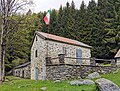
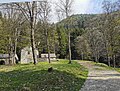
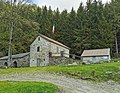
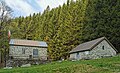
mountain pasture in the Italian municipality of Grandola ed Uniti      | |||||
| Upload media | |||||
| Instance of | |||||
|---|---|---|---|---|---|
| Location | Grandola ed Uniti, Province of Como, Lombardy, Italy | ||||
| Elevation above sea level |
| ||||
 | |||||
Italiano: L'Alpe Leveja (1317 m.) è un alpeggio in Val Sanagra, nel comune di Grandola ed Uniti.
Subcategories
This category has the following 2 subcategories, out of 2 total.
G
- Guidepost Alpe Leveja 1317 m (3 F)
H
Media in category "Alpe Leveja"
The following 22 files are in this category, out of 22 total.
-
 Alpe Leveja 01.jpg 7,296 × 5,472; 17.06 MB
-
 Alpe Leveja 02.jpg 2,838 × 5,231; 5.94 MB
-
 Alpe Leveja 03.jpg 3,398 × 2,590; 5.11 MB
-
 Alpe Leveja 04.jpg 3,648 × 2,736; 7.08 MB
-
 Alpe Leveja 05.jpg 3,648 × 2,736; 6.63 MB
-
 Alpe Leveja 06.jpg 3,648 × 2,736; 5.5 MB
-
 Alpe Leveja 07.jpg 5,493 × 2,326; 9.72 MB
-
 Alpe Leveja 08.jpg 3,506 × 1,990; 4.9 MB
-
 Alpe Leveja 09.jpg 3,420 × 2,600; 5.6 MB
-
 Alpe Leveja 10.jpg 5,278 × 2,337; 8.31 MB
-
 Alpe Leveja 11.jpg 2,874 × 2,362; 3.96 MB
-
 Alpe Leveja 12.jpg 3,370 × 2,604; 4.67 MB
-
 Alpe Leveja 13.jpg 6,073 × 2,223; 9.73 MB
-
 Alpe Leveja 14.jpg 3,408 × 2,286; 4.79 MB
-
 Alpe Leveja 15.jpg 3,648 × 2,736; 6 MB
-
 Alpe Leveja 16.jpg 3,540 × 2,534; 5.1 MB
-
 Alpe Leveja 17.jpg 2,964 × 2,302; 3.72 MB
-
 Alpe Leveja 18.jpg 3,446 × 2,098; 4.59 MB
-
 Alpe Leveja 19.jpg 3,323 × 1,886; 3.64 MB
-
 Alpe Leveja 20.jpg 3,248 × 2,301; 1.92 MB
-
 Photosphere at Alpe Leveja.jpg 5,322 × 2,661; 5.09 MB
-
 View on Sanagra and Alpe Leveja.jpg 3,648 × 2,736; 6.76 MB


