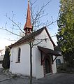
Category:Alte Kapelle St. Karl (Spitalstrasse 91b, Luzern)
| Object location | | View all coordinates using: OpenStreetMap |
|---|
chapel building in the city of Lucerne, Switzerland  | |||||
| Upload media | |||||
| Instance of | |||||
|---|---|---|---|---|---|
| Part of | |||||
| Named after | |||||
| Location | Lucerne, City of Lucerne Constituency, Lucerne, Switzerland | ||||
| Street address |
| ||||
| Heritage designation | |||||
 | |||||
Media in category "Alte Kapelle St. Karl (Spitalstrasse 91b, Luzern)"
This category contains only the following file.
-
 Karl Borromäus Kapelle 4.jpg 2,777 × 3,150; 2.4 MB