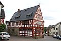
Category:Altes Rathaus (Niederbrechen)
| Object location | | View all coordinates using: OpenStreetMap |
|---|
cultural heritage monument  | |||||
| Upload media | |||||
| Instance of | |||||
|---|---|---|---|---|---|
| Location | Brechen, Limburg-Weilburg, Giessen Government Region, Hesse, Germany | ||||
| Street address |
| ||||
| Heritage designation | |||||
 | |||||
This is the category of the Hessian Kulturdenkmal (cultural monument) with the ID 50901 (Wikidata)
|
Subcategories
This category has only the following subcategory.
Media in category "Altes Rathaus (Niederbrechen)"
The following 10 files are in this category, out of 10 total.
-
 Altes Rathaus Niederbrechen 01.jpg 3,456 × 5,184; 9.96 MB
-
 Altes Rathaus Niederbrechen 02.jpg 5,184 × 3,456; 7.26 MB
-
 Altes Rathaus Niederbrechen 03.jpg 3,456 × 5,184; 7.75 MB
-
 Altes Rathaus Niederbrechen 04.jpg 3,456 × 5,184; 9.58 MB
-
 Altes Rathaus Niederbrechen detail 01.jpg 5,184 × 3,456; 9.62 MB
-
 Altes Rathaus Niederbrechen detail 02.jpg 5,184 × 3,456; 9.67 MB
-
 Altes Rathaus Niederbrechen detail 03.jpg 3,456 × 5,184; 11.64 MB
-
 Altes Rathaus Niederbrechen Tafel.jpg 5,184 × 3,456; 9.32 MB
-
 Niederbrechen Fachwerkhaus.jpg 3,606 × 2,586; 4.62 MB
-
 Rathausstraße17Niederbrechen.jpg 3,072 × 2,304; 1.17 MB


