Category:Am Plan 7, Pirna

| Object location | | View all coordinates using: OpenStreetMap |
|---|
| (Wikidata) |
| Upload media | |||||
| Instance of | |||||
|---|---|---|---|---|---|
| Location | Pirna, Sächsische Schweiz-Osterzgebirge, Saxony, Germany | ||||
| Heritage designation | |||||
 | |||||
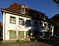
Deutsch: Wohnhaus in Ecklage, 18. Jh. (Wohnhaus); einfacher Putzbau, zum Teil Fachwerk, im Innern vier Hochwassermarken, baugeschichtlich, platzbildprägend und städtebaulich von Bedeutung
Media in category "Am Plan 7, Pirna"
The following 13 files are in this category, out of 13 total.
-
 Am Plan 7 Pirna.JPG 2,560 × 1,920; 2.93 MB
-
 Am Plan Pirna 118848891.jpg 5,184 × 3,888; 8.22 MB
-
 Am Plan Pirna 118848928.jpg 5,184 × 3,888; 9.41 MB
-
 Am Plan Pirna 118848932.jpg 3,888 × 5,184; 9.04 MB
-
 Am Plan Pirna 118848933.jpg 3,408 × 1,892; 2.58 MB
-
 Am Plan Pirna 118849584.jpg 5,184 × 3,888; 9.64 MB
-
 Am Plan Pirna 118849586.jpg 3,888 × 5,184; 8.68 MB
-
 Am Plan Pirna 118849588.jpg 5,184 × 3,888; 7.32 MB
-
 Am Plan Pirna 118849589.jpg 3,888 × 5,184; 6.16 MB
-
 Am Plan Pirna 118849611.jpg 3,888 × 5,184; 7.59 MB
-
 Am Plan Pirna 118849616.jpg 3,424 × 1,920; 2.87 MB
-
 Fassade gruene Fensterlaeden und wilder Wein Am Plan-7 Nikon-P500 2011.jpg 4,000 × 3,000; 6.57 MB
-
 Wohnhaus Am Plan 7 2011.jpg 3,916 × 3,056; 7.59 MB


