Category:Amalienstraße A 20 (Neuburg an der Donau)
| Object location | | View all coordinates using: OpenStreetMap |
|---|
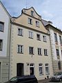
building in Neuburg an der Donau, Upper Bavaria, Germany  | |||||
| Upload media | |||||
| Instance of | |||||
|---|---|---|---|---|---|
| Location | Neuburg an der Donau, Neuburg-Schrobenhausen, Upper Bavaria, Bavaria, Germany | ||||
| Street address |
| ||||
| Heritage designation | |||||
 | |||||
This is the category of the Bavarian Baudenkmal (cultural heritage monument) with the ID D-1-85-149-8 (Wikidata)
|
Deutsch: Ehemaliges Stadtgerichts- oder Syndikatshaus. Dreigeschossiger giebelseitiger Bau mit geschweiftem Volutengiebel, wohl 16. Jahrhundert, dendrologische Datierung 1685/86 (Dachwerk), Fassade im frühen 18. Jahrhundert verändert
Amalienstraße A 20, Neuburg an der Donau, Bayern, Deutschland
Amalienstraße A 20, Neuburg an der Donau, Bayern, Deutschland
Media in category "Amalienstraße A 20 (Neuburg an der Donau)"
The following 3 files are in this category, out of 3 total.
-
 Amalienstr. A20 Neuburg-1.jpg 1,944 × 2,592; 706 KB
-
 Amalienstr. A20 Neuburg-2.jpg 1,890 × 2,544; 479 KB
-
 Amalienstr. A20 Neuburg-3.jpg 2,499 × 1,875; 472 KB

