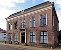
Category:Andreaehûs (Beetsterzwaag)
| Object location | | View all coordinates using: OpenStreetMap |
|---|
building in Opsterland, Netherlands  | |||||
| Upload media | |||||
| Instance of | |||||
|---|---|---|---|---|---|
| Location | Beetsterzwaag, Friesland, Netherlands | ||||
| Street address |
| ||||
| Located on street | |||||
| Heritage designation |
| ||||
 | |||||
Nederlands: Andreaehûs
|
This is a category about rijksmonument number 31832
|
| Address |
|
Media in category "Andreaehûs (Beetsterzwaag)"
The following 4 files are in this category, out of 4 total.
-
 Andreaehûs, Hoofdstraat 84, Beetsterzwaag.JPG 4,608 × 3,456; 3.51 MB
-
 Andreaehûs..JPG 4,608 × 3,456; 2.69 MB
-
 Hoofdstraat84 Beetsterzwaag.jpg 1,660 × 1,368; 544 KB
-
 Voorgevel - Beetsterzwaag - 20030105 - RCE.jpg 820 × 1,200; 245 KB


