Category:Angeles Crest Highway
highway over the San Gabriel Mountains, in Los Angeles County (CA)   | |||||
| Upload media | |||||
| Instance of | |||||
|---|---|---|---|---|---|
| Location |
| ||||
| Transport network | |||||
| Inception |
| ||||
| Length |
| ||||
| Terminus | |||||
 | |||||
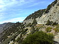
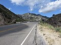
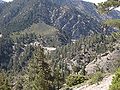
English: Angeles Crest Highway — northeastern section of California State Route 2 in the San Gabriel Mountains, within Los Angeles County, California.
- A designated California state scenic highway, and a National Forest Scenic Byway in the Angeles National Forest.
- Between Foothill Boulevard (in La Cañada Flintridge) and California State Route 138 (near Wrightwood). It reaches altitudes above 7,000 feet (2,100 m).
Subcategories
This category has the following 2 subcategories, out of 2 total.
M
- Mount Baden-Powell (33 F)
N
- Newcomb's Ranch (2 F)
Media in category "Angeles Crest Highway"
The following 22 files are in this category, out of 22 total.
-
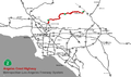 Angeles Crest Highway map.png 1,600 × 952; 282 KB
-
 AngelesCrestHighway-001.jpg 1,280 × 960; 257 KB
-
 AngelesCrestHighway-002.jpg 1,280 × 960; 229 KB
-
 AngelesCrestHighway-003.jpg 1,280 × 960; 218 KB
-
 AngelesCrestHighway-004.jpg 1,280 × 960; 309 KB
-
 Angeles Crest Highway 2019.jpg 4,608 × 3,456; 4.73 MB
-
 Angeles Crest Highway entrance 2019a.jpg 4,608 × 3,456; 3.89 MB
-
 Angeles Crest Highway entrance 2019b.jpg 4,608 × 3,456; 5.81 MB
-
 Entering Angeles National Forest on SR2 from the south 2014.jpg 2,400 × 1,714; 822 KB
-
 FEMA - 43689 - Road damageand workers in California.jpg 3,600 × 2,400; 5.6 MB
-
 Georges Gap 2019.jpg 4,608 × 3,456; 5.4 MB
-
 Islip-saddle.jpg 4,000 × 3,000; 2.89 MB
-
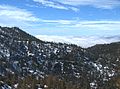 LA cloudbasin.jpg 2,310 × 1,718; 1.71 MB
-
 Minor rockfall on Angeles Crest Highway 2014-11-05.jpg 2,400 × 1,350; 1.04 MB
-
 Monrovia from Mount Wilson 2019.jpg 4,608 × 3,456; 3.44 MB
-
 Red Box Saddle 2019.jpg 4,608 × 3,456; 5.3 MB
-
 San Gabriel Mountains 5, CA.JPG 1,024 × 768; 272 KB
-
 Sunset haze view from Angeles Crest Highway 2014.jpg 4,800 × 1,600; 3.37 MB
-
 ACHtunnel,1949.jpg 691 × 524; 238 KB
-
 Tunnel To Eternity.jpg 6,016 × 4,016; 31.3 MB
-
 FEMA - 43692 - Road damage and workers in California.jpg 2,400 × 3,600; 6.06 MB
-
 Yucca plants 2019b.jpg 4,608 × 3,456; 5.9 MB


