Category:Anthony Hall
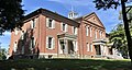
English: Anthony Memorial Hall was the main building for Storer College, a historically black college in Harpers Ferry, West Virginia, that operated from 1867 to 1955. It was built in 1848 as the quarters for the superintendent of the Harpers Ferry Armory, and during the Civil War was used as officer's quarters. It was transferred to Storer College in 1869, replacing Lockwood House as the school's headquarters. An addition was built in 1882, after which it housed the main library, a museum, music rooms, the chapel, a lecture room, science laboratories and administrative offices. In 1906, the first meeting in the United States of the Niagara Movement was held there.
The building is now the National Park Services's Mather Training Center, named after Stephen Tyng Mather, the first director of the NPS. (Description source: "Anthony Hall" NPS)
 .png) | |||||
| Upload media | |||||
| Instance of | |||||
|---|---|---|---|---|---|
| Located in protected area | |||||
| Location | Storer College, Harpers Ferry, Jefferson County, West Virginia | ||||
 | |||||
Media in category "Anthony Hall"
The following 8 files are in this category, out of 8 total.
-
 2022 Storer College, Anthony Hall 1.jpg 3,865 × 2,065; 2.62 MB
-
 2022 Storer College, Anthony Hall 2.jpg 3,944 × 2,766; 3.31 MB
-
 Anthony Hall Harpers Ferry WV1.jpg 8,688 × 4,974; 37.17 MB
-

-

-

-
 Anthony Memorial Hall.jpg 2,004 × 1,568; 1,013 KB
-
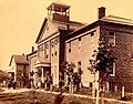
 Early post card, Storer College.jpg 1,148 × 689; 390 KB


