Category:April 1889 in California
English: Images/pictures taken in California during April 1889. Note this is not the date of the upload, nor the date a photo was scanned.
States of the United States: California · Louisiana · Texas · Washington · Wisconsin – Washington, D.C.
| April 1888 | ← | April 1889 | → | April 1890 | |||||||||
| Jan | Feb | Mar | Apr | May | Jun | Jul | Aug | Sep | Oct | Nov | Dec | ||
| ← | 0 | 0 | 8 | 35 | 3 | 0 | 0 | 0 | 4 | 1 | 1 | 18 | → |
|---|---|---|---|---|---|---|---|---|---|---|---|---|---|
Subcategories
This category has only the following subcategory.
Media in category "April 1889 in California"
The following 34 files are in this category, out of 34 total.
-

-

-
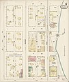
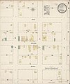
 Sanborn Fire Insurance Map from Colusa, Colusa County, California. LOC sanborn00475 002-1.tif 6,450 × 7,650; 141.17 MB
-
-
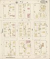
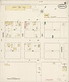
 Sanborn Fire Insurance Map from Colusa, Colusa County, California. LOC sanborn00475 002-2.tif 6,450 × 7,650; 141.17 MB
-

-
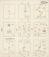
 Sanborn Fire Insurance Map from Colusa, Colusa County, California. LOC sanborn00475 002-3.tif 6,450 × 7,650; 141.17 MB
-

-
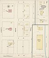
 Sanborn Fire Insurance Map from Colusa, Colusa County, California. LOC sanborn00475 002-4.tif 6,450 × 7,650; 141.17 MB
-
-
 Sanborn Fire Insurance Map from Colusa, Colusa County, California. LOC sanborn00475 002-5.tif 6,450 × 7,650; 141.17 MB
-

-
 Sanborn Fire Insurance Map from Colusa, Colusa County, California. LOC sanborn00475 002-6.tif 6,450 × 7,650; 141.17 MB
-
-
 Sanborn Fire Insurance Map from Colusa, Colusa County, California. LOC sanborn00475 002-7.tif 6,450 × 7,650; 141.17 MB
-
-
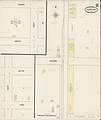
 Sanborn Fire Insurance Map from Corning, Tehama County, California. LOC sanborn00481 001-1.tif 6,450 × 7,650; 141.17 MB
-
-
 Sanborn Fire Insurance Map from Corning, Tehama County, California. LOC sanborn00481 001-2.tif 6,450 × 7,650; 141.17 MB
-
 Sanborn Fire Insurance Map from Orland, Glenn County, California. LOC sanborn00738 001-1.jpg 6,450 × 7,650; 3.18 MB
-
 Sanborn Fire Insurance Map from Orland, Glenn County, California. LOC sanborn00738 001-1.tif 6,450 × 7,650; 141.17 MB
-
 Sanborn Fire Insurance Map from Orland, Glenn County, California. LOC sanborn00738 001-2.jpg 6,450 × 7,650; 2.88 MB
-
 Sanborn Fire Insurance Map from Orland, Glenn County, California. LOC sanborn00738 001-2.tif 6,450 × 7,650; 141.17 MB
-
 Sanborn Fire Insurance Map from Arbuckle, Colusa County, California. LOC sanborn00389 001-1.tif 6,450 × 7,650; 141.17 MB
-
-
 Sanborn Fire Insurance Map from Arbuckle, Colusa County, California. LOC sanborn00389 001-2.tif 6,450 × 7,650; 141.17 MB
-

-
 Sanborn Fire Insurance Map from Willows, Glenn County, California. LOC sanborn00933 002-1.tif 6,450 × 7,650; 141.17 MB
-

-
 Sanborn Fire Insurance Map from Willows, Glenn County, California. LOC sanborn00933 002-2.tif 6,450 × 7,650; 141.17 MB
-

-
 Sanborn Fire Insurance Map from Willows, Glenn County, California. LOC sanborn00933 002-3.tif 6,450 × 7,650; 141.17 MB
-

-
 Sanborn Fire Insurance Map from Willows, Glenn County, California. LOC sanborn00933 002-4.tif 6,450 × 7,650; 141.17 MB


