Category:Aquia Church
| Object location | | View all coordinates using: OpenStreetMap |
|---|
church building in Virginia, United States of America  | |||||
| Upload media | |||||
| Instance of | |||||
|---|---|---|---|---|---|
| Location | Stafford County, Virginia | ||||
| Architectural style | |||||
| Heritage designation |
| ||||
| Inception |
| ||||
 | |||||
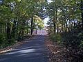
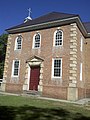
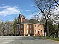
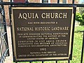
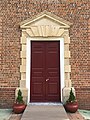
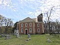
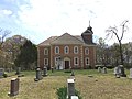
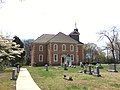
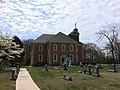
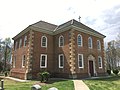
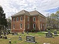
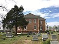
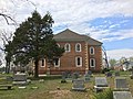
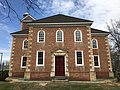
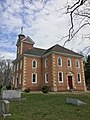
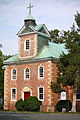
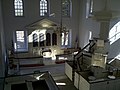
English: Aquia Church is a historic church and congregation in Aquia Harbor, Stafford County in the U.S. state of Virginia. The Episcopal congregation was founded in 1711, and the Georgian church was built between 1751 and 1755. Following a fire in 1757, the interior of the church was reconstructed. Aquia Church was designated a National Historic Landmark in 1991 for its architectural importance. Aquia Church is located at 2938 Jefferson Davis Highway (U.S. Route 1) at the highway's intersection with Virginia Secondary Route 610.
|
This is a category about a place or building that is listed on the National Register of Historic Places in the United States of America. Its reference number is 69000282. |
Media in category "Aquia Church"
The following 122 files are in this category, out of 122 total.
-
 Aquia 1.jpg 512 × 384; 65 KB
-
 Aquia Church (Stafford County, Virginia).jpg 467 × 333; 63 KB
-
 Aquia Church 2012-09-11 10-58-34.jpg 976 × 1,296; 81 KB
-
 Aquia Church 2012-09-11 10-59-52.jpg 2,448 × 3,264; 514 KB
-
 Aquia Church 2012-09-11 11-01-35.jpg 2,448 × 3,264; 828 KB
-
 Aquia Church 2012-09-11 11-04-56.jpg 3,264 × 2,448; 988 KB
-
 Aquia Church 2012-09-11 11-07-00.jpg 3,264 × 2,448; 899 KB
-
 Aquia Church 2012-09-11 11-08-10.jpg 2,448 × 3,264; 842 KB
-
 Aquia Church 2012-09-11 11-09-35.jpg 3,264 × 2,448; 1.03 MB
-
 Aquia Church 2012-09-11 11-11-22.jpg 2,448 × 3,264; 753 KB
-
 Aquia Church Aquia Harbour VA 2016 04 11 01.JPG 4,032 × 3,024; 2.94 MB
-
 Aquia Church Aquia Harbour VA 2016 04 11 02.JPG 4,032 × 3,024; 3.21 MB
-
 Aquia Church Aquia Harbour VA 2016 04 11 03.JPG 4,032 × 3,024; 3.22 MB
-
 Aquia Church Aquia Harbour VA 2016 04 11 04.JPG 3,024 × 4,032; 2.24 MB
-
 Aquia Church Aquia Harbour VA 2016 04 11 05.JPG 3,024 × 4,032; 2.36 MB
-
 Aquia Church Aquia Harbour VA 2016 04 11 06.JPG 4,032 × 3,024; 2.8 MB
-
 Aquia Church Aquia Harbour VA 2016 04 11 07.JPG 4,032 × 3,024; 2.83 MB
-
 Aquia Church Aquia Harbour VA 2016 04 11 08.JPG 4,032 × 3,024; 2.96 MB
-
 Aquia Church Aquia Harbour VA 2016 04 11 09.JPG 4,032 × 3,024; 3.15 MB
-
 Aquia Church Aquia Harbour VA 2016 04 11 10 (cropped).JPG 3,502 × 500; 696 KB
-
 Aquia Church Aquia Harbour VA 2016 04 11 10.JPG 4,032 × 3,024; 2.75 MB
-
 Aquia Church Aquia Harbour VA 2016 04 11 100.JPG 4,032 × 3,024; 5.93 MB
-
 Aquia Church Aquia Harbour VA 2016 04 11 101.JPG 4,032 × 3,024; 4.79 MB
-
 Aquia Church Aquia Harbour VA 2016 04 11 102.JPG 4,032 × 3,024; 4.25 MB
-
 Aquia Church Aquia Harbour VA 2016 04 11 103.JPG 4,032 × 3,024; 4.22 MB
-
 Aquia Church Aquia Harbour VA 2016 04 11 104.JPG 4,032 × 3,024; 3.29 MB
-
 Aquia Church Aquia Harbour VA 2016 04 11 105.JPG 4,032 × 3,024; 2.67 MB
-
 Aquia Church Aquia Harbour VA 2016 04 11 106.JPG 4,032 × 3,024; 3.01 MB
-
 Aquia Church Aquia Harbour VA 2016 04 11 11.JPG 4,032 × 3,024; 2.75 MB
-
 Aquia Church Aquia Harbour VA 2016 04 11 12.JPG 3,024 × 4,032; 2.98 MB
-
 Aquia Church Aquia Harbour VA 2016 04 11 13.JPG 3,024 × 4,032; 3.09 MB
-
 Aquia Church Aquia Harbour VA 2016 04 11 14.JPG 2,732 × 2,732; 1.98 MB
-
 Aquia Church Aquia Harbour VA 2016 04 11 15.JPG 3,024 × 4,032; 3.79 MB
-
 Aquia Church Aquia Harbour VA 2016 04 11 16.JPG 3,024 × 4,032; 2.3 MB
-
 Aquia Church Aquia Harbour VA 2016 04 11 17.JPG 3,024 × 4,032; 2.32 MB
-
 Aquia Church Aquia Harbour VA 2016 04 11 18.JPG 4,032 × 3,024; 3.01 MB
-
 Aquia Church Aquia Harbour VA 2016 04 11 19.JPG 4,032 × 3,024; 3.18 MB
-
 Aquia Church Aquia Harbour VA 2016 04 11 20.JPG 3,024 × 4,032; 3.12 MB
-
 Aquia Church Aquia Harbour VA 2016 04 11 21.JPG 3,024 × 4,032; 3.24 MB
-
 Aquia Church Aquia Harbour VA 2016 04 11 22.JPG 3,024 × 4,032; 6.51 MB
-
 Aquia Church Aquia Harbour VA 2016 04 11 23.JPG 4,032 × 3,024; 3.16 MB
-
 Aquia Church Aquia Harbour VA 2016 04 11 24.JPG 4,032 × 3,024; 3.34 MB
-
 Aquia Church Aquia Harbour VA 2016 04 11 25.JPG 4,032 × 3,024; 3.11 MB
-
 Aquia Church Aquia Harbour VA 2016 04 11 26.JPG 4,032 × 3,024; 2.96 MB
-
 Aquia Church Aquia Harbour VA 2016 04 11 27.JPG 4,032 × 3,024; 2.67 MB
-
 Aquia Church Aquia Harbour VA 2016 04 11 28.JPG 4,032 × 3,024; 2.43 MB
-
 Aquia Church Aquia Harbour VA 2016 04 11 29.JPG 4,032 × 3,024; 2.75 MB
-
 Aquia Church Aquia Harbour VA 2016 04 11 30.JPG 4,032 × 3,024; 2.95 MB
-
 Aquia Church Aquia Harbour VA 2016 04 11 31.JPG 4,032 × 3,024; 2.63 MB
-
 Aquia Church Aquia Harbour VA 2016 04 11 32.JPG 4,032 × 3,024; 2.62 MB
-
 Aquia Church Aquia Harbour VA 2016 04 11 33.JPG 3,024 × 4,032; 4.33 MB
-
 Aquia Church Aquia Harbour VA 2016 04 11 34.JPG 3,024 × 4,032; 4.23 MB
-
 Aquia Church Aquia Harbour VA 2016 04 11 35.JPG 4,032 × 3,024; 4.38 MB
-
 Aquia Church Aquia Harbour VA 2016 04 11 36.JPG 4,032 × 3,024; 3.96 MB
-
 Aquia Church Aquia Harbour VA 2016 04 11 37.JPG 4,032 × 3,024; 3.98 MB
-
 Aquia Church Aquia Harbour VA 2016 04 11 38.JPG 4,032 × 3,024; 4.41 MB
-
 Aquia Church Aquia Harbour VA 2016 04 11 39.JPG 4,032 × 3,024; 4.46 MB
-
 Aquia Church Aquia Harbour VA 2016 04 11 40.JPG 4,032 × 3,024; 2.99 MB
-
 Aquia Church Aquia Harbour VA 2016 04 11 41.JPG 4,032 × 3,024; 3.26 MB
-
 Aquia Church Aquia Harbour VA 2016 04 11 42.JPG 4,032 × 3,024; 3.68 MB
-
 Aquia Church Aquia Harbour VA 2016 04 11 43.JPG 4,032 × 3,024; 3.86 MB
-
 Aquia Church Aquia Harbour VA 2016 04 11 44.JPG 4,032 × 3,024; 3.73 MB
-
 Aquia Church Aquia Harbour VA 2016 04 11 45.JPG 4,032 × 3,024; 3.91 MB
-
 Aquia Church Aquia Harbour VA 2016 04 11 46.JPG 4,032 × 3,024; 3.73 MB
-
 Aquia Church Aquia Harbour VA 2016 04 11 47.JPG 4,032 × 3,024; 3.9 MB
-
 Aquia Church Aquia Harbour VA 2016 04 11 48.JPG 4,032 × 3,024; 3.85 MB
-
 Aquia Church Aquia Harbour VA 2016 04 11 49.JPG 4,032 × 3,024; 3.89 MB
-
 Aquia Church Aquia Harbour VA 2016 04 11 50.JPG 4,032 × 3,024; 3.79 MB
-
 Aquia Church Aquia Harbour VA 2016 04 11 51.JPG 4,032 × 3,024; 3.46 MB
-
 Aquia Church Aquia Harbour VA 2016 04 11 52.JPG 4,032 × 3,024; 3.6 MB
-
 Aquia Church Aquia Harbour VA 2016 04 11 53.JPG 3,024 × 4,032; 5.27 MB
-
 Aquia Church Aquia Harbour VA 2016 04 11 54.JPG 3,024 × 4,032; 5.33 MB
-
 Aquia Church Aquia Harbour VA 2016 04 11 55.JPG 3,024 × 4,032; 5.33 MB
-
 Aquia Church Aquia Harbour VA 2016 04 11 56.JPG 3,024 × 4,032; 5.3 MB
-
 Aquia Church Aquia Harbour VA 2016 04 11 57.JPG 3,024 × 4,032; 5.08 MB
-
 Aquia Church Aquia Harbour VA 2016 04 11 58.JPG 3,024 × 4,032; 5.77 MB
-
 Aquia Church Aquia Harbour VA 2016 04 11 59.JPG 3,024 × 4,032; 5.78 MB
-
 Aquia Church Aquia Harbour VA 2016 04 11 60.JPG 3,024 × 4,032; 5.72 MB
-
 Aquia Church Aquia Harbour VA 2016 04 11 61.JPG 4,032 × 3,024; 5.68 MB
-
 Aquia Church Aquia Harbour VA 2016 04 11 62.JPG 4,032 × 3,024; 5.56 MB
-
 Aquia Church Aquia Harbour VA 2016 04 11 63.JPG 3,024 × 4,032; 4.94 MB
-
 Aquia Church Aquia Harbour VA 2016 04 11 64.JPG 3,024 × 4,032; 5.6 MB
-
 Aquia Church Aquia Harbour VA 2016 04 11 65.JPG 4,032 × 3,024; 4.76 MB
-
 Aquia Church Aquia Harbour VA 2016 04 11 66.JPG 4,032 × 3,024; 5.38 MB
-
 Aquia Church Aquia Harbour VA 2016 04 11 67.JPG 4,032 × 3,024; 3.87 MB
-
 Aquia Church Aquia Harbour VA 2016 04 11 68.JPG 3,024 × 4,032; 3.97 MB
-
 Aquia Church Aquia Harbour VA 2016 04 11 69.JPG 4,032 × 3,024; 5.02 MB
-
 Aquia Church Aquia Harbour VA 2016 04 11 70.JPG 4,032 × 3,024; 3.17 MB
-
 Aquia Church Aquia Harbour VA 2016 04 11 71.JPG 4,032 × 3,024; 3.24 MB
-
 Aquia Church Aquia Harbour VA 2016 04 11 72.JPG 4,032 × 3,024; 3.25 MB
-
 Aquia Church Aquia Harbour VA 2016 04 11 73.JPG 4,032 × 3,024; 3.24 MB
-
 Aquia Church Aquia Harbour VA 2016 04 11 74.JPG 3,024 × 4,032; 3.34 MB
-
 Aquia Church Aquia Harbour VA 2016 04 11 75.JPG 4,032 × 3,024; 3.56 MB
-
 Aquia Church Aquia Harbour VA 2016 04 11 76.JPG 4,032 × 3,024; 3.67 MB
-
 Aquia Church Aquia Harbour VA 2016 04 11 77.JPG 4,032 × 3,024; 3.56 MB
-
 Aquia Church Aquia Harbour VA 2016 04 11 78.JPG 3,024 × 4,032; 3.52 MB
-
 Aquia Church Aquia Harbour VA 2016 04 11 79.JPG 3,024 × 4,032; 3.41 MB
-
 Aquia Church Aquia Harbour VA 2016 04 11 80.JPG 4,032 × 3,024; 5.98 MB
-
 Aquia Church Aquia Harbour VA 2016 04 11 81.JPG 4,032 × 3,024; 3.43 MB
-
 Aquia Church Aquia Harbour VA 2016 04 11 82.JPG 4,032 × 3,024; 5.62 MB
-
 Aquia Church Aquia Harbour VA 2016 04 11 83.JPG 3,024 × 4,032; 5.05 MB
-
 Aquia Church Aquia Harbour VA 2016 04 11 84.JPG 3,024 × 4,032; 4.89 MB
-
 Aquia Church Aquia Harbour VA 2016 04 11 85.JPG 4,032 × 3,024; 2.84 MB
-
 Aquia Church Aquia Harbour VA 2016 04 11 86.JPG 4,032 × 3,024; 2.93 MB
-
 Aquia Church Aquia Harbour VA 2016 04 11 87.JPG 3,024 × 4,032; 3.8 MB
-
 Aquia Church Aquia Harbour VA 2016 04 11 88.JPG 3,024 × 4,032; 3.74 MB
-
 Aquia Church Aquia Harbour VA 2016 04 11 89.JPG 4,032 × 3,024; 3.58 MB
-
 Aquia Church Aquia Harbour VA 2016 04 11 90.JPG 4,032 × 3,024; 3.95 MB
-
 Aquia Church Aquia Harbour VA 2016 04 11 91.JPG 4,032 × 3,024; 3.88 MB
-
 Aquia Church Aquia Harbour VA 2016 04 11 92.JPG 4,032 × 3,024; 4.06 MB
-
 Aquia Church Aquia Harbour VA 2016 04 11 93.JPG 4,032 × 3,024; 4.09 MB
-
 Aquia Church Aquia Harbour VA 2016 04 11 94.JPG 4,032 × 3,024; 4.61 MB
-
 Aquia Church Aquia Harbour VA 2016 04 11 95.JPG 4,032 × 3,024; 4.23 MB
-
 Aquia Church Aquia Harbour VA 2016 04 11 96.JPG 4,032 × 3,024; 4.39 MB
-
 Aquia Church Aquia Harbour VA 2016 04 11 97.JPG 4,032 × 3,024; 3.08 MB
-
 Aquia Church Aquia Harbour VA 2016 04 11 98.JPG 4,032 × 3,024; 5.75 MB
-
 Aquia Church Aquia Harbour VA 2016 04 11 99.JPG 4,032 × 3,024; 6.26 MB
-
 Aquia Church, Stratford, Virginia.jpg 2,660 × 1,440; 864 KB
-
 Aquia Church.jpg 2,848 × 4,272; 4.87 MB
-
 Aquia interior.jpg 3,264 × 2,448; 2.31 MB
-
 Aquia pulpit.jpg 306 × 408; 26 KB
-
 Old churches, ministers and families of Virginia (1900) (14596633759).jpg 2,656 × 1,424; 881 KB

.jpg)


_(14596633759).jpg)
.JPG)