Category:Arabic-language maps of North America
Temperate regions: North America · South America · Africa · Europe · Asia · Oceania – Polar regions: – Other regions:
Countries of North America: Antigua and Barbuda · the Bahamas ≈ Bahamas · Barbados · Belize · Canada · Costa Rica · Cuba · Dominica · the Dominican Republic ≈ Dominican Republic · El Salvador · Grenada · Guatemala · Haiti · Honduras · Jamaica · Mexico · Nicaragua · Panama · Saint Kitts and Nevis · Saint Lucia · Saint Vincent and the Grenadines · Trinidad and Tobago‡ · the United States‡ ≈ United States‡
Other territories: Anguilla · Bermuda · the British Virgin Islands ≈ British Virgin Islands · the Cayman Islands ≈ Cayman Islands · the Florida Keys ≈ Florida Keys · Greenland · Guadeloupe · Martinique · Montserrat · Puerto Rico · Saint-Barthélemy · Saint Martin (France) · Saint-Pierre and Miquelon · the Turks and Caicos Islands ≈ Turks and Caicos Islands · the United States Virgin Islands ≈ United States Virgin Islands
‡: partly located in North America
Media in category "Arabic-language maps of North America"
The following 15 files are in this category, out of 15 total.
-
 2012 US presidential election Electoral College map-ar.svg 1,020 × 593; 40 KB
-
 Amérique du Nord politique avec la lettre en persan - btv1b53066533m.jpg 15,716 × 12,363; 34.17 MB
-
 Carib Territory-ar.svg 1,500 × 1,189; 182 KB
-
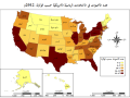 Choropath Map 2012a-ar.svg 677 × 503; 138 KB
-
 FourCorners.jpg 461 × 516; 39 KB
-
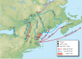 King williams war-ar.svg 638 × 455; 1.75 MB
-
 Lincoln Sea map-ar.png 1,000 × 913; 287 KB
-
 Map of Dominica-ar.gif 327 × 350; 32 KB
-
 Map of USA with state names ar.svg 959 × 593; 344 KB
-
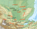
 Maya civilization location map-ar.svg 1,800 × 1,500; 1.53 MB
-
 Nordamerikanische Kulturareale ar.png 1,490 × 1,700; 745 KB
-
 NorteDeGuatemalaSiglosXVI-XVII-ar.svg 1,386 × 1,064; 14.38 MB
-
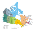 Political map of Canada ar.png 693 × 599; 147 KB
-
 Slavery in the 13 colonies-ar.jpg 550 × 611; 119 KB
-
 Wpdms king james grants-ar.png 300 × 542; 101 KB


