Category:Arbirlot (civil parish)
Scottish parish in Angus, Scotland, UK | |||||
| Upload media | |||||
| Instance of | |||||
|---|---|---|---|---|---|
| Named after | |||||
| Location |
| ||||
| Population |
| ||||
| Area |
| ||||
 | |||||
Subcategories
This category has the following 2 subcategories, out of 2 total.
A
L
Media in category "Arbirlot (civil parish)"
The following 175 files are in this category, out of 175 total.
-
 A "Minor Light" at Elliot - geograph.org.uk - 4603900.jpg 481 × 640; 59 KB
-
 A92 at Nether Kelly - geograph.org.uk - 4753953.jpg 640 × 480; 62 KB
-

-
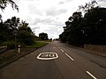
 A92 eastbound - geograph.org.uk - 3375207.jpg 640 × 480; 32 KB
-
 A92 eastbound - geograph.org.uk - 3375217.jpg 640 × 480; 30 KB
-
 A92 eastbound - geograph.org.uk - 3375218.jpg 640 × 480; 32 KB
-
 A92 eastbound - geograph.org.uk - 3375222.jpg 640 × 480; 31 KB
-
 A92 eastbound - geograph.org.uk - 3375227.jpg 640 × 480; 35 KB
-
 A92 eastbound - geograph.org.uk - 3375237.jpg 640 × 480; 30 KB
-
 A92 eastbound - geograph.org.uk - 3375243.jpg 640 × 480; 38 KB
-
 A92 heading east - geograph.org.uk - 3714801.jpg 640 × 480; 57 KB
-
 A92 heading east - geograph.org.uk - 3714827.jpg 640 × 480; 48 KB
-
 A92 heading east - geograph.org.uk - 3714834.jpg 640 × 480; 46 KB
-
 Aftermath of Rain - geograph.org.uk - 5421416.jpg 640 × 427; 424 KB
-
 Arbirlot - geograph.org.uk - 4190904.jpg 800 × 450; 304 KB
-
 Arbirlot from the Kirkyard - geograph.org.uk - 3384755.jpg 640 × 427; 411 KB
-
 Arbirlot sewage plant - geograph.org.uk - 5400039.jpg 2,560 × 1,920; 1.51 MB
-
 Arbroath Golf Course - geograph.org.uk - 4151688.jpg 640 × 480; 57 KB
-
 Arbroath, 10th hole, Balmirmer - geograph.org.uk - 5340431.jpg 5,184 × 3,888; 5.08 MB
-
 Arbroath, 11th hole, Johnnie's Howe - geograph.org.uk - 5340437.jpg 5,184 × 3,888; 4.69 MB
-
 Arbroath, 13th hole, Dowrie - geograph.org.uk - 5340453.jpg 5,184 × 3,888; 4.22 MB
-
 Arbroath, 14th hole, The Secretary - geograph.org.uk - 5340462.jpg 5,184 × 3,888; 5.02 MB
-
 Arbroath, 15th hole, Penston Burn - geograph.org.uk - 5340467.jpg 5,184 × 3,888; 4.69 MB
-
 Arbroath, 16th hole, The Dunes - geograph.org.uk - 5340474.jpg 5,184 × 3,888; 4.42 MB
-
 Arbroath, 17th hole, The Ditch - geograph.org.uk - 5340478.jpg 5,184 × 3,888; 4.95 MB
-
 Arbroath, 18th hole, Wormie Hill - geograph.org.uk - 5340484.jpg 5,184 × 3,888; 4.09 MB
-
 Arbroath, 1st hole, Francie's Well - geograph.org.uk - 5340359.jpg 640 × 480; 55 KB
-
 Arbroath, 2nd hole, Balcathie - geograph.org.uk - 5340366.jpg 5,184 × 3,888; 5.66 MB
-
 Arbroath, 3rd hole, The Dennie - geograph.org.uk - 5340374.jpg 5,184 × 3,888; 4.57 MB
-
 Arbroath, 4th hole, Lint Pot - geograph.org.uk - 5340380.jpg 5,184 × 3,888; 5 MB
-
 Arbroath, 5th hole, Mains of Kelly - geograph.org.uk - 5340386.jpg 5,184 × 3,888; 5.76 MB
-
 Arbroath, 9th hole, The Shelter - geograph.org.uk - 5340421.jpg 5,184 × 3,888; 4.85 MB
-
 B9127 near Arbroath - geograph.org.uk - 3232414.jpg 1,200 × 797; 379 KB
-
 B9127, Denhead of Arbirlot - geograph.org.uk - 2186553.jpg 640 × 480; 67 KB
-
 Baird's malting - geograph.org.uk - 5400120.jpg 2,560 × 1,920; 3.3 MB
-
 Baird's malting - geograph.org.uk - 5400126.jpg 2,560 × 1,920; 3.12 MB
-
 Balbinnie - geograph.org.uk - 4630344.jpg 800 × 450; 324 KB
-
 Beach south of West Links, Arbroath - geograph.org.uk - 3061868.jpg 1,024 × 681; 103 KB
-
 Beach south of West Links, Arbroath - geograph.org.uk - 3061871.jpg 1,024 × 682; 251 KB
-
 Beach, Arbroath - geograph.org.uk - 5170783.jpg 800 × 534; 195 KB
-
 Beach, West Links - geograph.org.uk - 5400005.jpg 1,024 × 683; 215 KB
-
 Beach, West Links - geograph.org.uk - 5400009.jpg 1,024 × 683; 297 KB
-
 Beehives near Easter Bonhard Farm - geograph.org.uk - 1087450.jpg 640 × 427; 152 KB
-
 Big Bale, Denhead of Arbirlot - geograph.org.uk - 2186696.jpg 640 × 481; 82 KB
-
 Blue Door - geograph.org.uk - 3384786.jpg 427 × 640; 441 KB
-
 Bonnyton Smiddy - geograph.org.uk - 4190878.jpg 800 × 450; 325 KB
-
 Bridge, Elliot Junction - geograph.org.uk - 5399997.jpg 1,024 × 683; 260 KB
-
 Broomhill, Arbirlot - geograph.org.uk - 4297824.jpg 640 × 480; 48 KB
-
 Building on the Arbroath Artisans Golf Course - geograph.org.uk - 3061882.jpg 1,024 × 681; 186 KB
-
 Bus stop off the A92 - geograph.org.uk - 3714825.jpg 640 × 480; 49 KB
-
 Carnoustie to Arbroath railway line - geograph.org.uk - 3283232.jpg 1,600 × 1,200; 796 KB
-
 Clubhouse, Arbroath Artisan Golf Club - geograph.org.uk - 5170785.jpg 800 × 534; 150 KB
-
 Common Vetch (Vicia sativa) - geograph.org.uk - 5421422.jpg 640 × 427; 348 KB
-
 Copse near Fauldiehill - geograph.org.uk - 6105369.jpg 5,184 × 3,888; 5.14 MB
-
 Cottage west of Arbirlot - geograph.org.uk - 6105378.jpg 5,184 × 3,888; 7.04 MB
-
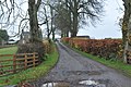
 Country road at East Balmirmer - geograph.org.uk - 4581985.jpg 640 × 480; 62 KB
-
 Crop field near Nether Kelly - geograph.org.uk - 3714813.jpg 640 × 480; 48 KB
-
 Crop field south of the A92 - geograph.org.uk - 3714829.jpg 640 × 480; 62 KB
-
 Crop field south of the A92 - geograph.org.uk - 3714856.jpg 640 × 480; 127 KB
-
 Crops at Balbinnie - geograph.org.uk - 4586433.jpg 640 × 480; 52 KB
-
 Crudie - geograph.org.uk - 4190910.jpg 800 × 600; 361 KB
-
 Crudie Farm - geograph.org.uk - 4137878.jpg 640 × 427; 380 KB
-
 Cycle track near Elliot - geograph.org.uk - 4151677.jpg 640 × 480; 65 KB
-
 Dismantled railway track - geograph.org.uk - 5400028.jpg 2,560 × 1,920; 3.45 MB
-
 Drain beside National Cycle Route 1 - geograph.org.uk - 3714816.jpg 640 × 480; 74 KB
-
 Dundee Road - geograph.org.uk - 5170790.jpg 800 × 534; 152 KB
-
 Dundee Road, Arbroath - geograph.org.uk - 5399873.jpg 2,560 × 1,920; 2.69 MB
-
 East Balmirmer - geograph.org.uk - 6105394.jpg 5,184 × 3,888; 6.11 MB
-
 East Coast Railway Line at Elliot - geograph.org.uk - 6546991.jpg 5,184 × 3,888; 5.65 MB
-
 Easter Bonhard Farm - geograph.org.uk - 1087456.jpg 640 × 427; 191 KB
-
 Elliot roundabout on A92 - geograph.org.uk - 4543990.jpg 640 × 480; 39 KB
-
 Elliot Water - geograph.org.uk - 5400014.jpg 2,560 × 1,920; 3.36 MB
-
 Elliot Water at Arbirlot - geograph.org.uk - 3232339.jpg 1,200 × 797; 729 KB
-
 Elliot Water at its mouth - geograph.org.uk - 2773416.jpg 640 × 482; 91 KB
-

-
 Elliot Water waterfall - geograph.org.uk - 5400046.jpg 2,560 × 1,920; 3.23 MB
-
 Entering Arbroath - geograph.org.uk - 3714876.jpg 640 × 480; 56 KB
-
 Fairneyknowe (geograph 4137888).jpg 640 × 427; 367 KB
-
 Farm road to Peasiehill - geograph.org.uk - 3232412.jpg 1,200 × 797; 412 KB
-
 Farm track near East Balmirmer - geograph.org.uk - 3232332.jpg 1,200 × 797; 508 KB
-
 Farm track near Elliot - geograph.org.uk - 3714862.jpg 640 × 480; 54 KB
-
 Farm track near Nether Kelly - geograph.org.uk - 3714823.jpg 640 × 480; 43 KB
-
 Farmland near Elliot - geograph.org.uk - 3714868.jpg 640 × 480; 72 KB
-
 Fast food restaurant, Arbroath - geograph.org.uk - 3714921.jpg 640 × 480; 68 KB
-
 Field at Mains of Kelly - geograph.org.uk - 5189505.jpg 640 × 480; 47 KB
-
 Field at West Balmirmer - geograph.org.uk - 4582541.jpg 640 × 480; 112 KB
-
 Field at West Balmirmer - geograph.org.uk - 6105367.jpg 5,184 × 3,888; 6.22 MB
-
 Field tracks - geograph.org.uk - 6105391.jpg 5,184 × 3,888; 7.33 MB
-
 Field Wall near Elliott - geograph.org.uk - 3384738.jpg 640 × 379; 375 KB
-
 Field, Pitcundrum - geograph.org.uk - 4190871.jpg 800 × 450; 313 KB
-
 Fields, Braeside - geograph.org.uk - 4190897.jpg 800 × 450; 257 KB
-
 Footbridge near Kellie Castle - geograph.org.uk - 1087375.jpg 427 × 640; 226 KB
-

-
 Footpath South of Braeside - geograph.org.uk - 1087443.jpg 427 × 640; 173 KB
-
 Footpath to Arbirlot school - geograph.org.uk - 1087438.jpg 460 × 640; 187 KB
-
 Former Free Kirk - geograph.org.uk - 3384792.jpg 542 × 640; 520 KB
-
 Fungi, Denhead of Arbirlot - geograph.org.uk - 2186554.jpg 640 × 480; 111 KB
-

-

-
 Gorse on Knox Hill - geograph.org.uk - 6105372.jpg 5,184 × 3,888; 5.44 MB
-
 Greenford - geograph.org.uk - 4190882.jpg 800 × 450; 286 KB
-
 Hielan' Coos - geograph.org.uk - 5421425.jpg 640 × 480; 113 KB
-
 House beside Arbroath Artisans Golf Course - geograph.org.uk - 3061888.jpg 1,024 × 682; 179 KB
-
 House near Kellie Castle - geograph.org.uk - 3384748.jpg 640 × 427; 392 KB
-
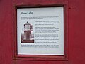 Information about the "Minor Light" - geograph.org.uk - 4603902.jpg 640 × 481; 54 KB
-

-
 Links south of Arbroath - geograph.org.uk - 5170776.jpg 800 × 534; 147 KB
-
 Main road and railway - geograph.org.uk - 5399888.jpg 2,560 × 1,920; 3.3 MB
-
 Mains of Kelly - geograph.org.uk - 1087426.jpg 640 × 427; 138 KB
-
 Mains of Kelly road - geograph.org.uk - 6105388.jpg 5,184 × 3,888; 5.65 MB
-
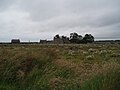
 Masts and ruined buildings at Balbinnie - geograph.org.uk - 3232324.jpg 1,200 × 797; 416 KB
-
 Mill Hill - geograph.org.uk - 1087461.jpg 427 × 640; 186 KB
-
 Millstone set into a wall at Arbirlot - geograph.org.uk - 3232338.jpg 1,200 × 797; 707 KB
-
 Minor road at Balbinnie - geograph.org.uk - 3232325.jpg 1,200 × 797; 391 KB
-
 Minor road at Mains of Kelly - geograph.org.uk - 3232334.jpg 1,200 × 797; 473 KB
-
 Minor road near East Balmirmer - geograph.org.uk - 3232331.jpg 1,200 × 797; 424 KB
-
 Minor road near East Bonhard - geograph.org.uk - 3232336.jpg 1,200 × 797; 539 KB
-
 Minor road near East Bonhard - geograph.org.uk - 3232337.jpg 1,200 × 797; 494 KB
-
 Minor road near Fauldiehill - geograph.org.uk - 3232327.jpg 1,200 × 797; 563 KB
-
 Minor road near Panlathy - geograph.org.uk - 3232322.jpg 1,200 × 797; 452 KB
-
 Minor road near Panlathy - geograph.org.uk - 3232323.jpg 1,200 × 797; 395 KB
-
 Minor road near Pitcundrum Farm - geograph.org.uk - 3232326.jpg 1,200 × 797; 452 KB
-
 Muirdrum - geograph.org.uk - 4603572.jpg 640 × 480; 65 KB
-
 National Cycle Route 1 - geograph.org.uk - 3714819.jpg 640 × 480; 54 KB
-
 National Cycle Route 1 - geograph.org.uk - 3714832.jpg 640 × 480; 65 KB
-
 National Cycle Route 1 - geograph.org.uk - 3714835.jpg 640 × 480; 60 KB
-
 National Cycle Route 1 - geograph.org.uk - 3714869.jpg 640 × 480; 63 KB
-
 Near Woodville Feus - geograph.org.uk - 5421411.jpg 640 × 427; 376 KB
-
 Nether Kelly - geograph.org.uk - 3714805.jpg 640 × 480; 56 KB
-
 Nether Kelly - geograph.org.uk - 5177157.jpg 800 × 534; 201 KB
-
 Nether Kelly Farm - geograph.org.uk - 1087414.jpg 640 × 427; 131 KB
-
 Newton of Arbirlot - geograph.org.uk - 4137884.jpg 640 × 427; 420 KB
-
 Old A92 - geograph.org.uk - 4190752.jpg 800 × 450; 284 KB
-
 Panlathy Mill - geograph.org.uk - 3232321.jpg 1,200 × 797; 628 KB
-
 Panlathy Mill - geograph.org.uk - 4603569.jpg 640 × 480; 59 KB
-
 Panlathymill Burn at Muirdrum - geograph.org.uk - 4603573.jpg 640 × 480; 98 KB
-

-
 Path to Braeside playing fields - geograph.org.uk - 3232335.jpg 1,200 × 797; 435 KB
-
 Path, West Links, Arbroath - geograph.org.uk - 6160013.jpg 2,000 × 1,333; 336 KB
-
 Peasiehill farm - geograph.org.uk - 5400095.jpg 2,560 × 1,920; 3.26 MB
-
 Penston Burn - geograph.org.uk - 5170780.jpg 800 × 534; 152 KB
-
 Pitcundrum - geograph.org.uk - 4190873.jpg 800 × 450; 293 KB
-
 Pitcundrum Farm - geograph.org.uk - 4586427.jpg 640 × 480; 61 KB
-

-
 Ploughed Land at Balcathie - geograph.org.uk - 3384742.jpg 640 × 427; 377 KB
-
 Polytunnels (without the poly) - geograph.org.uk - 3714860.jpg 640 × 480; 54 KB
-
 Potato Crop - geograph.org.uk - 4137900.jpg 640 × 402; 402 KB
-
 Potato field - geograph.org.uk - 4192745.jpg 800 × 600; 431 KB
-
 Quarry, Craigend - geograph.org.uk - 4190886.jpg 800 × 600; 471 KB
-

-
 Road heading to Bonnyton Smiddy - geograph.org.uk - 6105370.jpg 5,184 × 3,888; 6.76 MB
-
 Road into Arbirlot - geograph.org.uk - 3232340.jpg 1,200 × 797; 617 KB
-
 Road past cottages at West Balmirmer - geograph.org.uk - 3232328.jpg 1,200 × 797; 477 KB
-
 Road to Arbirlot - geograph.org.uk - 6105383.jpg 5,184 × 3,888; 6.83 MB
-
 Road to Balcathie - geograph.org.uk - 5030527.jpg 640 × 480; 48 KB
-
 Road, Panlathy - geograph.org.uk - 4190813.jpg 800 × 450; 301 KB
-
 Shingle beach at West Links - geograph.org.uk - 2259601.jpg 640 × 480; 105 KB
-
 Sign for footpath to Arbirlot school - geograph.org.uk - 1087435.jpg 427 × 640; 163 KB
-
 Site of former Elliot Junction Station, Arbroath - geograph.org.uk - 6160024.jpg 2,000 × 1,333; 341 KB
-

-
 Stubble, Braeside - geograph.org.uk - 4190902.jpg 800 × 450; 333 KB
-
 Stubble, Craigend - geograph.org.uk - 4190892.jpg 800 × 450; 306 KB
-
 Sunlit beach near Elliot - geograph.org.uk - 2773400.jpg 640 × 482; 91 KB
-

-
 Tattie Field - geograph.org.uk - 4137893.jpg 640 × 423; 343 KB
-

-

-
 Train passing level crossing south of Arbroath - geograph.org.uk - 3061881.jpg 1,024 × 681; 119 KB
-
 Train passing West Links, Arbroath - geograph.org.uk - 6160019.jpg 2,000 × 1,333; 241 KB
-
 Waterfall - geograph.org.uk - 3384773.jpg 640 × 427; 535 KB
-
 Waterlogged field, Nether Kelly - geograph.org.uk - 3714807.jpg 640 × 480; 56 KB
-
 West Links park, Arbroath - geograph.org.uk - 6160011.jpg 2,000 × 1,333; 387 KB
-
 Westway Retail Park, Arbroath - geograph.org.uk - 6160033.jpg 2,000 × 1,333; 331 KB
-
 Window shopping 'au chemin de fer' - geograph.org.uk - 4543968.jpg 4,608 × 3,456; 3.19 MB
-
 Winter cereals, West Balmirmer - geograph.org.uk - 5177162.jpg 800 × 534; 209 KB


_-_geograph.org.uk_-_5421422.jpg)


.jpg)


_-_geograph.org.uk_-_3714860.jpg)


