Category:Aresing
municipality of Germany _St._Wenzeslaus_255.jpg)   | |||||
| Upload media | |||||
| Instance of |
| ||||
|---|---|---|---|---|---|
| Part of |
| ||||
| Location | Neuburg-Schrobenhausen, Upper Bavaria, Bavaria, Germany | ||||
| Head of government |
| ||||
| Population |
| ||||
| Area |
| ||||
| Elevation above sea level |
| ||||
| official website | |||||
 | |||||
Subcategories
This category has the following 3 subcategories, out of 3 total.
B
O
Media in category "Aresing"
The following 7 files are in this category, out of 7 total.
-
 Wappen Aresing.png 90 × 99; 4 KB
-
 Wappen von Aresing.svg 708 × 774; 44 KB
-
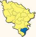 Aresing - Lage im Landkreis.png 181 × 185; 24 KB
-
 Aresing in ND.svg 529 × 553; 965 KB
-
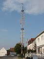
 AresingMaibaum-MJ.jpg 1,260 × 2,059; 1.31 MB
-
 AresingMaibaum.jpg 1,613 × 2,150; 1.64 MB
-
 Dorfstraße von Aresing, Franz von Lenbach.jpg 1,100 × 878; 179 KB


